File:Geostationaryjava3Dsideview.gif
無更高解析度可提供。
Geostationaryjava3Dsideview.gif (220 × 220 像素,檔案大小:111 KB,MIME 類型:image/gif、循環、163 畫格、12秒)
摘要
| 描述 |
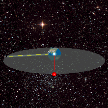
English: A geostationary orbit can only be achieved at an altitude very close to 35,786 km (22,236 mi), and directly above the equator. This equates to an orbital velocity of 3.07 km/s (1.91 mi/s) or a period of 1,436 minutes, which equates to almost exactly one sidereal day or 23.934461223 hours. This makes sense considering that the satellite must be locked to the Earth's rotational period in order to have a stationary footprint on the ground. In practice, this means that all geostationary satellites have to exist on this ring http://weelookang.blogspot.com/2010/07/ejs-open-source-geostationary-satellite.html |
| 日期 | |
| 來源 | 自己的作品 |
| 作者 | Lookang many thanks to author of original simulation = Francisco Esquembre author of Easy Java Simulation = Francisco Esquembre |
| 授權許可 (重用此檔案) |
我,本作品的著作權持有者,決定用以下授權條款發佈本作品: 此檔案採用創用CC 姓名標示-相同方式分享 3.0 未在地化版本授權條款。
|
檔案歷史
點選日期/時間以檢視該時間的檔案版本。
| 日期/時間 | 縮圖 | 尺寸 | 使用者 | 備註 | |
|---|---|---|---|---|---|
| 目前 | 2013年6月12日 (三) 05:04 | | 220 × 220(111 KB) | Lookang | updated earth texture with public domain better resolution |
| 2013年6月12日 (三) 05:02 |  | 220 × 220(420 KB) | Lookang | updated with public domain earth texture. radius of earth is proportional to geostationary orbit now | |
| 2011年6月27日 (一) 01:29 |  | 220 × 220(420 KB) | Lookang |
檔案用途
下列頁面有用到此檔案:
全域檔案使用狀況
以下其他 wiki 使用了這個檔案:
- ar.wikipedia.org 的使用狀況
- ast.wikipedia.org 的使用狀況
- bn.wikipedia.org 的使用狀況
- ca.wikipedia.org 的使用狀況
- en.wikipedia.org 的使用狀況
- eo.wikipedia.org 的使用狀況
- es.wikipedia.org 的使用狀況
- es.wikiversity.org 的使用狀況
- et.wikipedia.org 的使用狀況
- fa.wikipedia.org 的使用狀況
- fr.wikipedia.org 的使用狀況
- gl.wikipedia.org 的使用狀況
- he.wikipedia.org 的使用狀況
- hi.wikipedia.org 的使用狀況
- hu.wikipedia.org 的使用狀況
- ml.wikipedia.org 的使用狀況
- ms.wikipedia.org 的使用狀況
- no.wikipedia.org 的使用狀況
- pl.wikipedia.org 的使用狀況
- pt.wikipedia.org 的使用狀況
- ru.wikipedia.org 的使用狀況
- simple.wikipedia.org 的使用狀況
- ta.wikipedia.org 的使用狀況
- te.wikipedia.org 的使用狀況
- tg.wikipedia.org 的使用狀況
- th.wikipedia.org 的使用狀況
- uk.wikipedia.org 的使用狀況