File:Miletus Bay silting evolution map-en.svg

此 SVG 檔案的 PNG 預覽的大小:800 × 581 像素。 其他解析度:320 × 232 像素 | 640 × 465 像素 | 1,024 × 744 像素 | 1,280 × 930 像素 | 2,560 × 1,860 像素 | 1,857 × 1,349 像素。
原始檔案 (SVG 檔案,表面大小:1,857 × 1,349 像素,檔案大小:1.54 MB)
摘要
| 拍攝地點 | | 位於此地的本圖片與其他圖片: OpenStreetMap |
|---|
| 描述 |
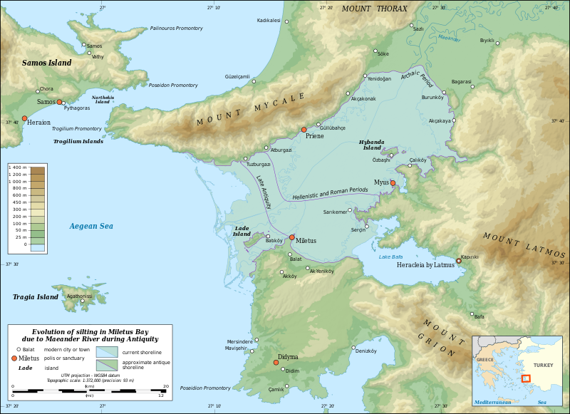
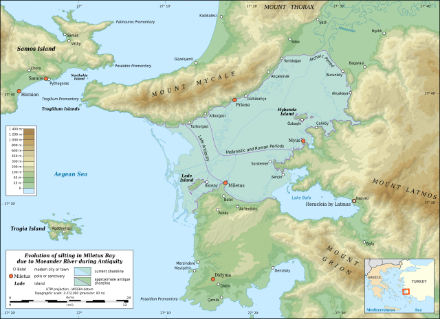
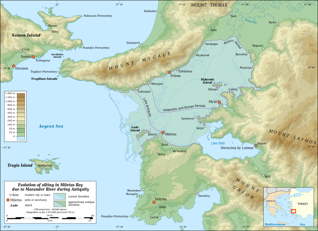
English: Map in English showing the silting evolution of Miletus Bay due to the alluvium brought by the Maeander River during Antiquity. Are also displayed some of the modern cities and towns of the area, the current course of the Maeander River and the current shoreline.
Notes:
Français : Carte en anglais de l'évolution de l'ensablement de la baie de Milet dû aux alluvions déposés par le Méandre. Sont aussi montrés le parcours actuel du Méandre, le littoral actuel et diverses agglomérations modernes. Notes :
UTM projection – WGS84 datum |
||
| 日期 | |||
| 來源 |
自己的作品
|
||
| 作者 | Eric Gaba (Sting - fr:Sting) | ||
| 授權許可 (重用此檔案) |
|
||
| 其他版本 |
|


|
This SVG file contains embedded text that can be translated into your language, using any capable SVG editor, text editor or the SVG Translate tool. For more information see: About translating SVG files. |
授權條款
Eric Gaba, Wikimedia Commons user Sting,此作品的版權所有人,決定用以下授權條款發佈本作品:

|
已授權您依據自由軟體基金會發行的無固定段落、封面文字和封底文字GNU自由文件授權條款1.2版或任意後續版本,對本檔進行複製、傳播和/或修改。該協議的副本列在GNU自由文件授權條款中。 |
此檔案採用創用CC 姓名標示-相同方式分享 3.0 未在地化版本授權條款。
姓名標示: Eric Gaba, Wikimedia Commons user Sting
- 您可以自由:
- 分享 – 複製、發佈和傳播本作品
- 重新修改 – 創作演繹作品
- 惟需遵照下列條件:
- 姓名標示 – 您必須指名出正確的製作者,和提供授權條款的連結,以及表示是否有對內容上做出變更。您可以用任何合理的方式來行動,但不得以任何方式表明授權條款是對您許可或是由您所使用。
- 相同方式分享 – 如果您利用本素材進行再混合、轉換或創作,您必須基於如同原先的相同或兼容的條款,來分布您的貢獻成品。
您可以選擇您需要的授權條款。
檔案歷史
點選日期/時間以檢視該時間的檔案版本。
| 日期/時間 | 縮圖 | 尺寸 | 使用者 | 備註 | |
|---|---|---|---|---|---|
| 目前 | 2010年7月16日 (五) 21:00 | | 1,857 × 1,349(1.54 MB) | Sting | Test: embedded sRGB profile |
| 2009年7月2日 (四) 12:22 |  | 1,857 × 1,349(1.59 MB) | Sting | == Summary == {{Location|37|35|00|N|27|16|00|E|scale:500000}} <br/> {{Information| |Description={{en|Map in English showing the silting evolution of Miletus Bay due to the alluvium brought by the [[:en:Büyük Menderes River|Maeander Rive |
檔案用途
全域檔案使用狀況
以下其他 wiki 使用了這個檔案:
- ar.wikipedia.org 的使用狀況
- azb.wikipedia.org 的使用狀況
- az.wikipedia.org 的使用狀況
- bg.wikipedia.org 的使用狀況
- ca.wikipedia.org 的使用狀況
- ceb.wikipedia.org 的使用狀況
- cs.wikipedia.org 的使用狀況
- de.wikipedia.org 的使用狀況
- de.wikivoyage.org 的使用狀況
- el.wikipedia.org 的使用狀況
- en.wikipedia.org 的使用狀況
- Miletus
- Priene
- Battle of Mycale
- Didyma
- Büyük Menderes River
- Mycale
- Lake Bafa
- Battle of Lade (201 BCE)
- Myus
- Beşparmak Mountains
- Dilek Peninsula-Büyük Menderes Delta National Park
- Wikipedia:Featured picture candidates/October-2016
- Wikipedia:Featured picture candidates/Miletus Bay Silting Map
- User:Abyssal/bla
- Lydian–Milesian War
- es.wikipedia.org 的使用狀況
- fa.wikipedia.org 的使用狀況
- fi.wikipedia.org 的使用狀況
- fr.wikipedia.org 的使用狀況
- he.wikipedia.org 的使用狀況
- hr.wikipedia.org 的使用狀況
檢視此檔案的更多全域使用狀況。