File:Miranda2.JPG
預覽大小:659 × 600 像素。 其他解析度:264 × 240 像素 | 527 × 480 像素 | 844 × 768 像素 | 1,201 × 1,093 像素。
原始檔案 (1,201 × 1,093 像素,檔案大小:144 KB,MIME 類型:image/jpeg)
摘要
| 描述 |
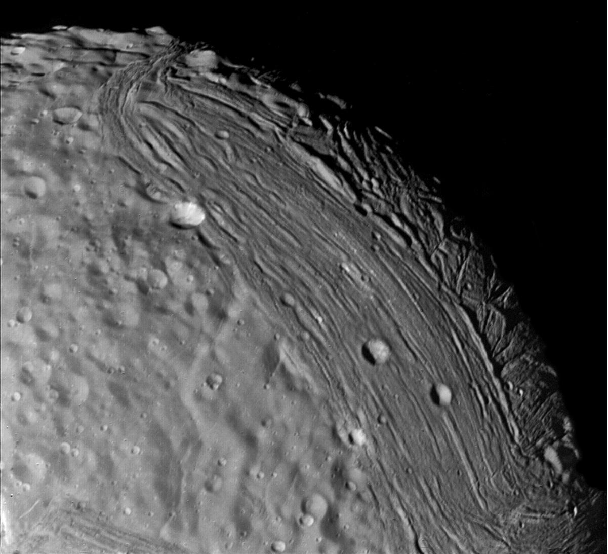
English: Miranda reveals a complex geologic history in this view, acquired by Voyager 2 on January 24, 1986, around its close approach to the Uranian moon. At least three terrain types of different age and geologic style are evident at this resolution of about 700 meters (2,300 feet). Visible in this clear-filter, narrow-angle image are, from left: (1) an apparently ancient, cratered terrain consisting of rolling, subdued hills and degraded medium-sized craters (2) a grooved terrain with linear valleys and ridges developed at the expense of, or replacing, the first terrain type: and (3) a complex terrain seen along the terminator, in which intersecting curvilinear ridges and troughs are abruptly truncated by the linear, grooved terrain. Voyager scientists believe this third terrain type is intermediate in age between the first two. |
|||||
| 日期 | ||||||
| 來源 | https://photojournal.jpl.nasa.gov/catalog/PIA00141 | |||||
| 作者 | NASA/JPL | |||||
| 授權許可 (重用此檔案) |
|
授權條款
| 本作品由NASA創作,屬於公有領域。根據NASA的版權政策:“NASA的創作除非另有聲明否則不受版權保護。”(參見:Template:PD-USGov/zh,NASA版權政策或JPL圖像使用政策) | ||
 |
警告:
|
檔案歷史
點選日期/時間以檢視該時間的檔案版本。
| 日期/時間 | 縮圖 | 尺寸 | 使用者 | 備註 | |
|---|---|---|---|---|---|
| 目前 | 2006年8月26日 (六) 13:06 | | 1,201 × 1,093(144 KB) | Brallan~commonswiki | == Description == Miranda reveals a complex geologic history in this view, acquired by Voyager 2 on January 24, 1986, around its close approach to the Uranian moon. At least three terrain types of different age and geologic style are evident at this resol |
檔案用途
下列頁面有用到此檔案:
全域檔案使用狀況
以下其他 wiki 使用了這個檔案:
- af.wikipedia.org 的使用狀況
- ar.wikipedia.org 的使用狀況
- ca.wikipedia.org 的使用狀況
- de.wikipedia.org 的使用狀況
- en.wikipedia.org 的使用狀況
- eo.wikipedia.org 的使用狀況
- fr.wikipedia.org 的使用狀況
- hy.wikipedia.org 的使用狀況
- id.wikipedia.org 的使用狀況
- lb.wikipedia.org 的使用狀況
- ms.wikipedia.org 的使用狀況
- pl.wikipedia.org 的使用狀況
- ro.wikipedia.org 的使用狀況
- ru.wikipedia.org 的使用狀況
- uk.wikipedia.org 的使用狀況
- zh-yue.wikipedia.org 的使用狀況