File:Napier06.jpg

預覽大小:800 × 593 像素。 其他解析度:320 × 237 像素 | 640 × 474 像素 | 1,024 × 758 像素 | 1,280 × 948 像素。
原始檔案 (1,280 × 948 像素,檔案大小:149 KB,MIME 類型:image/jpeg)
摘要
Informations in English
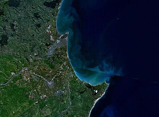
- Description: This is a NASA World Wind composite satellite image of New Zealand, showing Napier, Hastings, and Cape Kidnappers.
Informationen auf Deutsch
- Beschreibung: Dieses NASA World Wind-Bild zeigt den südlichen Teil der Hawke's Bay, insbesondere die Städte Napier und Hastings sowie Cape Kidnappers in Neuseeland.
授權條款
| 本圖像屬於公有領域,因其為NASA的World Wind衛星地圖瀏覽器的一張截圖,且使用了公有領域圖層,如Blue Marble、MODIS、Landsat、SRTM、USGS、GLOBE等。
|
 |
檔案歷史
點選日期/時間以檢視該時間的檔案版本。
| 日期/時間 | 縮圖 | 尺寸 | 使用者 | 備註 | |
|---|---|---|---|---|---|
| 目前 | 2006年3月18日 (六) 21:04 | | 1,280 × 948(149 KB) | 2000 | ===Informations in English=== *Description: NASA World Wind composite satellite image of New Zealand, showing Napier, Hastings, and Cape Kidnappers. ===Informationen auf Deutsch=== *Beschreibung: Dieses NASA World Wind-Bild zeigt d |
檔案用途
下列頁面有用到此檔案:
全域檔案使用狀況
以下其他 wiki 使用了這個檔案:
- de.wikipedia.org 的使用狀況
- en.wikipedia.org 的使用狀況
- eo.wikipedia.org 的使用狀況
- fr.wikipedia.org 的使用狀況
- hi.wikipedia.org 的使用狀況
- it.wikipedia.org 的使用狀況
- nn.wikipedia.org 的使用狀況
- www.wikidata.org 的使用狀況