File:Operation Kutusov (map).jpg
Operation_Kutusov_(map).jpg (605 × 453 像素,檔案大小:106 KB,MIME 類型:image/jpeg)
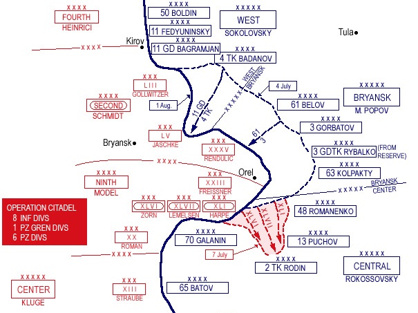
- Description: Battle of Kutusov - 12 July-19 August 1943
- Source: www.dean.usma.edu archive copy at the Wayback Machine
- Background information:
In 1938 the predecessors of what is today The Department of History at the United States Military Academy began developing a series of campaign atlases to aid in teaching cadets a course entitled, "History of the Military Art." Since then, the Department has produced over six atlases and more than one thousand maps, encompassing not only America’s wars but global conflicts as well.
In keeping abreast with today's technology, the Department of History is providing these maps on the internet as part of the department's outreach program. The maps were created by the United States Military Academy’s Department of History and are the digital versions from the atlases printed by the United States Defense Printing Agency. We gratefully acknowledge the accomplishments of the department's former cartographer, Mr. Edward J. Krasnoborski, along with the works of our present cartographer, Mr. Frank Martini.
Please be aware that these maps are large in file size and may require substantial download times.
|
|
 |

|
本圖片是以PNG、GIF或JPEG格式上傳。然而,其中包含的資料或訊息,應該重新建立成可縮放向量圖形(SVG)檔案,以更有效率或更準確的方式儲存。如有可能,請上傳本圖片的SVG格式版本。在上傳之後,請修改維基各姊妹計畫中所有使用舊版圖片的條目(列在圖像連結章節中),替換為新版圖片,並在舊圖片的描述頁中加入{{Vector version available|新圖片名稱.svg}}模板,同時移除本模板。
|


.jpg?uselang=zh-hant)
.jpg?uselang=zh-hant)
.jpg?action=history&uselang=zh-hant)
.jpg)
檔案歷史
點選日期/時間以檢視該時間的檔案版本。
| 日期/時間 | 縮圖 | 尺寸 | 使用者 | 備註 | |
|---|---|---|---|---|---|
| 目前 | 2013年6月1日 (六) 03:04 | | 605 × 453(106 KB) | Gunbirddriver2 | User created page with UploadWizard |
檔案用途
下列頁面有用到此檔案:
全域檔案使用狀況
以下其他 wiki 使用了這個檔案:
- bg.wikipedia.org 的使用狀況
- cs.wikipedia.org 的使用狀況
- de.wikipedia.org 的使用狀況
- en.wikipedia.org 的使用狀況
- Operation Kutuzov
- 70th Guards Rifle Division
- 250th Rifle Division (Soviet Union)
- 15th Tank Corps
- 7th Guards Tank Division
- 97th Rifle Division
- 83rd Guards Rifle Division
- 84th Guards Rifle Division
- 202nd Rifle Division (Soviet Union)
- 212th Rifle Division
- 217th Rifle Division
- 235th Rifle Division
- 197th Rifle Division
- 186th Rifle Division (1939 formation)
- et.wikipedia.org 的使用狀況
- fi.wikipedia.org 的使用狀況
- fr.wikipedia.org 的使用狀況
- he.wikipedia.org 的使用狀況
- it.wikipedia.org 的使用狀況
- ka.wikipedia.org 的使用狀況
- nl.wikipedia.org 的使用狀況
- no.wikipedia.org 的使用狀況
- pl.wikipedia.org 的使用狀況
- pt.wikipedia.org 的使用狀況
- ru.wikipedia.org 的使用狀況
.jpg)