File:PIA21489 - Advance Inspection of NASA's Next Mars Landing Site.jpg

原始檔案 (1,650 × 1,275 像素,檔案大小:267 KB,MIME 類型:image/jpeg)
摘要
| 描述 |
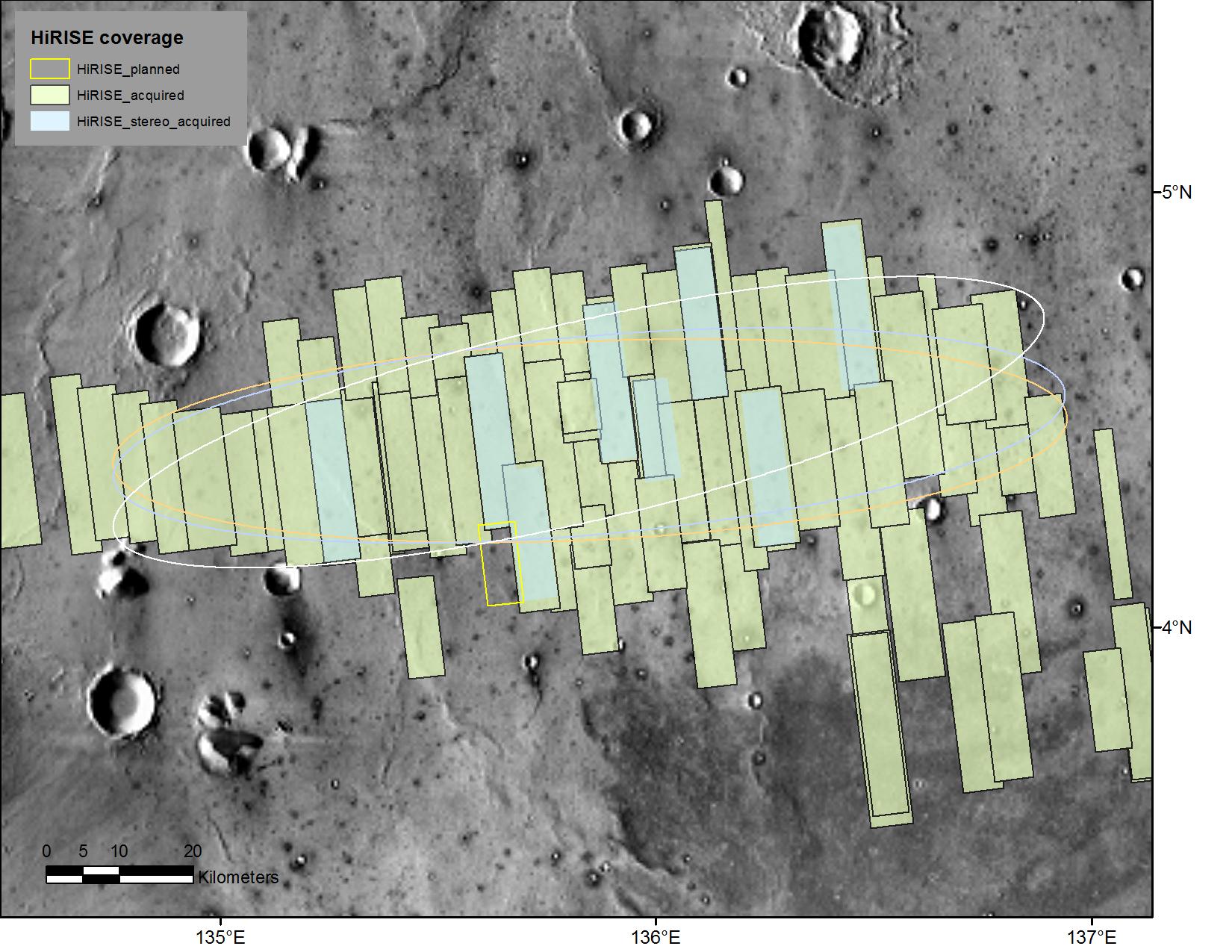
English: This map shows footprints of images taken from Mars orbit by the High Resolution Imaging Science Experiment (HiRISE) camera as part of advance analysis of the area where NASA's InSight mission will land in 2018. The final planned image of the set is targeted to fill in the yellow-outlined rectangle on March 30, 2017.
HiRISE is one of six science instruments on NASA's Mars Reconnaissance Orbiter, which reached Mars in 2006 and surpassed 50,000 orbits on March 27, 2017. The map covers an area about 100 miles (160 kilometers) across. HiRISE has been used since 2006 to inspect dozens of candidate landing sites on Mars, including the sites where the Phoenix and Curiosity missions landed in 2008 and 2012. The site selected for InSight's Nov. 26, 2018, landing is on a flat plain in the Elysium Planitia region of Mars, between 4 and 5 degrees north of the equator. HiRISE images are detailed enough to reveal individual boulders big enough to be a landing hazard. The March 30 observation that completes the planned advance imaging of this landing area brings the number of HiRISE images of the area to 73. Some are pairs covering the same ground. Overlapping observations provide stereoscopic, 3-D information for evaluating characteristics such as slopes. On this map, coverage by stereo pairs is coded in pale blue, compared to the gray-green of single HiRISE image footprints. The ellipses on the map are about 81 miles (130 kilometers) west-to-east by about 17 miles (27 kilometers) north-to-south. InSight has about 99 percent odds of landing within the ellipse for which it is targeted. The three ellipses indicate landing expectations for three of the possible InSight launch dates: white outline for launch at the start of the launch period, on May 5, 2018; blue for launch on May 26, 2018; orange for launch on June 8, 2018. InSight -- an acronym for "Interior Exploration using Seismic Investigations, Geodesy and Heat Transport" -- will study the deep interior of Mars to improve understanding about how rocky planets like Earth formed and evolved. The University of Arizona, Tucson, operates HiRISE, which was built by Ball Aerospace & Technologies Corp., Boulder, Colorado. NASA's Jet Propulsion Laboratory, a division of Caltech in Pasadena, California, manages the Mars Reconnaissance Orbiter Project and the InSight Project for NASA's Science Mission Directorate, Washington. Lockheed Martin Space Systems, Denver, built the orbiter and is building the lander. |
| 日期 | 29 March 2017 (published) |
| 來源 | Catalog page · Full-res (JPEG · TIFF) |
| 作者 | NASA/JPL-Caltech/Univ. of Arizona |
| 火星上的位置 | 位於此地的本圖片與其他圖片: Google地图 |
|---|
| 此標籤不表示文件的著作權狀態。任何文件在附有此標籤的同時還需要一個有效的著作權標籤。請參閱許可協議說明頁面以了解更多資訊。 其他語言:
|
 |
This media is a product of the Mars Reconnaissance Orbiter mission Credit and attribution belongs to the High Resolution Imaging Science Experiment (HiRISE) team, NASA/JPL-Caltech/Univ. of Arizona |
授權條款
| 本作品由NASA創作,屬於公有領域。根據NASA的版權政策:“NASA的創作除非另有聲明否則不受版權保護。”(參見:Template:PD-USGov/zh,NASA版權政策或JPL圖像使用政策) | ||
 |
警告:
|
檔案歷史
點選日期/時間以檢視該時間的檔案版本。
| 日期/時間 | 縮圖 | 尺寸 | 使用者 | 備註 | |
|---|---|---|---|---|---|
| 目前 | 2017年3月30日 (四) 21:58 | | 1,650 × 1,275(267 KB) | PhilipTerryGraham | User created page with UploadWizard |
檔案用途
下列頁面有用到此檔案:
全域檔案使用狀況
以下其他 wiki 使用了這個檔案:
- en.wikipedia.org 的使用狀況
- fr.wikipedia.org 的使用狀況
- uk.wikipedia.org 的使用狀況