File:PequeñaEntente.svg

此 SVG 檔案的 PNG 預覽的大小:800 × 589 像素。 其他解析度:320 × 236 像素 | 640 × 471 像素 | 1,024 × 754 像素 | 1,280 × 942 像素 | 2,560 × 1,884 像素 | 822 × 605 像素。
原始檔案 (SVG 檔案,表面大小:822 × 605 像素,檔案大小:113 KB)
| 描述 |
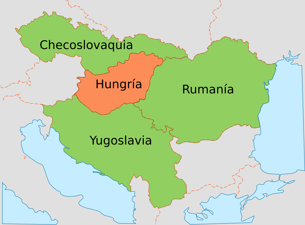
Español: Mapa con los países de la wikipedia:es:Pequeña Entente y su principal adversario, Hungría.
English: Map showing the Little Entente and its main adversary, Hungary. |
| 日期 | (UTC) |
| 來源 | |
| 作者 |
|
| 這是一張修飾過的圖片,即本圖片是用軟體修改過後的版本,修改的方式或內容有:New map using the borders in the original。原版圖片來源:WW2 Holocaust Europe map-fr.svg。修改者:Rowanwindwhistler。
|
我,本作品的著作權持有者,決定用以下授權條款發佈本作品:
此檔案採用創用CC 姓名標示 3.0 未在地化版本授權條款。
- 您可以自由:
- 分享 – 複製、發佈和傳播本作品
- 重新修改 – 創作演繹作品
- 惟需遵照下列條件:
- 姓名標示 – 您必須指名出正確的製作者,和提供授權條款的連結,以及表示是否有對內容上做出變更。您可以用任何合理的方式來行動,但不得以任何方式表明授權條款是對您許可或是由您所使用。
原始上傳日誌
This image is a derivative work of the following images:
- File:WW2_Holocaust_Europe_map-fr.svg licensed with Cc-by-3.0
- 2009-05-11T16:52:07Z Sémhur 1310x1090 (607330 Bytes) {{Information |Description=Map of the Holocaust in Europe during World War II, 1939-1945. This map shows all extermination camps (or ''death camps''), most major concentration camps, labor camps, prison camps, ghettos, major
Uploaded with derivativeFX
檔案歷史
點選日期/時間以檢視該時間的檔案版本。
| 日期/時間 | 縮圖 | 尺寸 | 使用者 | 備註 | |
|---|---|---|---|---|---|
| 目前 | 2016年12月7日 (三) 13:16 | | 822 × 605(113 KB) | Rowanwindwhistler | https://en.wikipedia.org/wiki/Wikipedia:WikiProject_Maps/Conventions Fake text added |
| 2010年8月29日 (日) 11:29 |  | 822 × 605(83 KB) | Rowanwindwhistler | {{Information |Description={{es|1=Mapa con los países de la wikipedia:es:Pequeña Entente y su principal adversario, Hungría.}} {{en|1=Map showing the Little Entente and its main adversary, Hungary.}} |Source=*[[:File:WW2_Holocaust_Europe_map-fr.svg |
檔案用途
全域檔案使用狀況
以下其他 wiki 使用了這個檔案:
- ast.wikipedia.org 的使用狀況
- en.wikipedia.org 的使用狀況
- eo.wikipedia.org 的使用狀況
- es.wikipedia.org 的使用狀況
- pt.wikipedia.org 的使用狀況
- ro.wikipedia.org 的使用狀況