File:SAR Kilauea.jpg

原始檔案 (1,000 × 1,000 像素,檔案大小:333 KB,MIME 類型:image/jpeg)
| 描述 | PIA01763: Space Radar Image of Kilauea, Hawaii - interferometry 1 |
| 日期 | |
| 來源 | http://photojournal.jpl.nasa.gov/catalog/PIA01763 |
| 作者 | JPL |
| 授權許可 (重用此檔案) |
Courtesy NASA/JPL-Caltech, http://www.jpl.nasa.gov/images/policy/ |
| 本作品由NASA創作,屬於公有領域。根據NASA的版權政策:“NASA的創作除非另有聲明否則不受版權保護。”(參見:Template:PD-USGov/zh,NASA版權政策或JPL圖像使用政策) | ||
 |
警告:
|
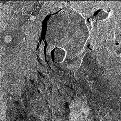
Original Caption Released with Image: Data acquired on April 13, 1994 and on October 4, 1994 from the X-band Synthetic Aperture Radar on board the space shuttle Endeavour were used to generate interferometric fringes, which were overlaid on the X-SAR image of Kilauea. The volcano is centered in this image at 19.58 degrees north latitude and 155.55 degrees west longitude. The image covers about 9 kilometers by 13 kilometers (5.6 miles by 8 miles). The X-band fringes correspond clearly to the expected topographic image. The yellow line indicates the area below which was used for the three-dimensional image using altitude lines. The yellow rectangular frame fences the area for the final topographic image.
Spaceborne Imaging Radar-C and X-band Synthetic Aperture Radar (SIR-C/X-SAR) is part of NASA's Mission to Planet Earth. The radars illuminate Earth with microwaves, allowing detailed observations at any time, regardless of weather or sunlight conditions. SIR-C/X-SAR uses three microwave wavelengths: L-band (24 cm), C-band (6 cm) and X-band (3 cm). The multi-frequency data will be used by the international scientific community to better understand the global environment and how it is changing. The SIR-C/X-SAR data, complemented by aircraft and ground studies, will give scientists clearer insights into those environmental changes which are caused by nature and those changes which are induced by human activity.
SIR-C was developed by NASA's Jet Propulsion Laboratory. X-SAR was developed by the Dornier and Alenia Spazio companies for the German space agency, Deutsche Agentur fuer Raumfahrtangelegenheiten (DARA), and the Italian space agency, Agenzia Spaziale Italiana (ASI), with the Deutsche Forschungsanstalt fuer Luft und Raumfahrt e.V.(DLR), the major partner in science, operations and data processing of X-SAR. The Instituto Ricerca Elettromagnetismo Componenti Elettronici (IRECE) at the University of Naples was a partner in interferometry analysis.
| 註解 | 該圖片含有註解:在維基媒體共享資源上查看註解 |
檔案歷史
點選日期/時間以檢視該時間的檔案版本。
| 日期/時間 | 縮圖 | 尺寸 | 使用者 | 備註 | |
|---|---|---|---|---|---|
| 目前 | 2007年3月30日 (五) 10:50 | | 1,000 × 1,000(333 KB) | Eve Hall~commonswiki | {{Information |Description=PIA01763: Space Radar Image of Kilauea, Hawaii - interferometry 1 |Source=http://photojournal.jpl.nasa.gov/catalog/PIA01763 |Date=1999-05-01 |Author=JPL |Permission=Courtesy NASA/JPL-Caltech, http://www.jpl.nasa.gov/images/polic |
檔案用途
下列頁面有用到此檔案:
全域檔案使用狀況
以下其他 wiki 使用了這個檔案:
- en.wikipedia.org 的使用狀況
- es.wikipedia.org 的使用狀況
- et.wikipedia.org 的使用狀況
- uk.wikipedia.org 的使用狀況