File:Seto Inland Sea satellite.jpg

預覽大小:800 × 544 像素。 其他解析度:320 × 218 像素 | 640 × 435 像素 | 1,024 × 696 像素。
原始檔案 (1,024 × 696 像素,檔案大小:242 KB,MIME 類型:image/jpeg)
| 描述 |
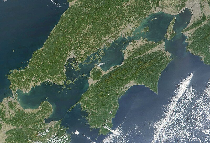
日本語: 瀬戸内海 Seto-naikai
Deutsch: Die Seto-Inlandsee ist ein Binnenmeer das die japanischen Inseln Honshū, Shikoku und Kyūshū voneinander trennt.
English: Formally named the Seto Inland Sea, the Inland Sea is the body of water separating Honshū, Shikoku, two of the main islands of Japan, and Kyūshū. |
| 日期 | |
| 來源 | Cropped from: http://visibleearth.nasa.gov/view_rec.php?id=2206 |
| 作者 | Jacques Descloitres, MODIS Land Rapid Response Team, NASA/GSFC |
| 本作品由NASA創作,屬於公有領域。根據NASA的版權政策:“NASA的創作除非另有聲明否則不受版權保護。”(參見:Template:PD-USGov/zh,NASA版權政策或JPL圖像使用政策) | ||
 |
警告:
|
檔案歷史
點選日期/時間以檢視該時間的檔案版本。
| 日期/時間 | 縮圖 | 尺寸 | 使用者 | 備註 | |
|---|---|---|---|---|---|
| 目前 | 2004年11月22日 (一) 21:21 | | 1,024 × 696(242 KB) | Tsui | Japan, the Seto inland-lake |
檔案用途
超過 100 個頁面有用到此檔案。 下列清單只列出前 100 筆有用到此檔案的頁面。 您也可以檢視完整清單。
- 四國
- 瀨戶內海
- User:AKwToHoKoLaTeCeOaEas
- User:Altt311/MainPage
- User:Altt311/首頁2
- User:Aplikasi
- User:Apple77226/MainPage
- User:Beanchung/Register/WikipediaFront
- User:Bus88MRT/Tratra22395768
- User:C933103/MainPage
- User:Celumio
- User:Chsi/tp
- User:Cuilw/MainPage
- User:Dorisman
- User:Eistein/MainPage
- User:Goodisyou
- User:HW~zhwiki/mp2011
- User:HW~zhwiki/mp2011/1
- User:Ilvava/自定首页
- User:Iv0202/首頁測試
- User:J87j8787/MainPage
- User:Jackmeng
- User:John123521/Main Page/簡單版面首頁
- User:Johnzheng
- User:Kevinhksouth/首頁/2006
- User:Kevinhksouth/首頁/2009/A
- User:Kevinhksouth/首頁/2009/B
- User:Kevinhksouth/首頁/2009/B/較大字體
- User:Kivary/homepage
- User:Kivary/homepage2
- User:Littlebtc/main new
- User:Littlebtc/main new 2
- User:Littlebtc/mainpage09
- User:Mindcat/2010年4月2日首页
- User:Mkn~zhwiki/Main page 2
- User:Mkn~zhwiki/Main page 3
- User:Mkn~zhwiki/Main page 4
- User:Mmm333k/MainPage
- User:Mosesofmason/Main Page
- User:Pan3858/維基百科首頁
- User:Pedist/首頁
- User:PhiLiP/iWiki-content.js
- User:PhiLiP/首页/修改建议
- User:Shengwei95
- User:Shizhao/首页
- User:Smallmiew/2007年首頁
- User:Stevenliuyi/MainPage
- User:Symplectopedia/如果没有人回退破坏,维基百科就会变成这样
- User:Upsuper/2010新首页
- User:Upsuper/2010新首页/2
- User:Upsuper/2010新首页/3
- User:Upsuper/2010新首页/4
- User:Upsuper/2010新首页/try
- User:Upsuper/首页
- User:Uzzzzer/samplefrontpage
- User:WHLChk33/2009年首頁改版
- User:WHLChk33/2009年首頁改版2
- User:Waihorace/2009年首頁改版討論設計
- User:Waihorace/2009年首頁改版討論設計/1
- User:Waihorace/2009年首頁改版討論設計/2
- User:Waihorace/main page 2010 3
- User:Waihorace/main page 2010 4
- User:Waihorace/mpc11/draft1
- User:Waihorace/mpc11/draft1/v2
- User:Waihorace/mpdesign/kuailong
- User:Waihorace/mpdesign/kuailong jason
- User:Wowovr2/首頁
- User:Wudicgi/Main Page
- User:Yzugsr/SandBox
- User:Zaze~zhwiki
- User:Zealotzuo
- User:Zilong0419/OldMainPage
- User:ゼータ/homepage
- User:ゼータ/工具箱
- User:光合成/首頁
- User:奔流沙/test
- User:子房/test
- User:帝國皇帝
- User:愿聞其詳/主頁
- User:愿聞其詳/試做首頁
- User:长夜无风/首页
- User:頭版
- User talk:Bus88MRT/Tratra22395768
- User talk:GN94
- Wikipedia:2009年首頁改版計劃/首頁最後定案
- Wikipedia:模板消息/首页
- Wikipedia:首頁/temp06
- Wikipedia:首頁/temp08
- Wikipedia:首頁/temp1
- Wikipedia:首頁/temp2
- Wikipedia:首頁/簡單版面設計
- Wikipedia:首页/2004年2月到9月間的版本
- Wikipedia:首页/2004版
- Wikipedia:首页/temp07
- Wikipedia:首页/自訂首頁設計/2004年版本
- Wikipedia:首页/自訂首頁設計/deep
- Wikipedia:首页/自訂首頁設計/gray
- Wikipedia:首页/自訂首頁設計/orange
- Wikipedia:首页/自订首页设计/2005年版本
- Wikipedia:首页/自订首页设计/2006年版本
檢視連結到這個檔案的更多連結。
全域檔案使用狀況
以下其他 wiki 使用了這個檔案:
- en.wikipedia.org 的使用狀況
- fr.wikipedia.org 的使用狀況
- it.wikivoyage.org 的使用狀況
- ja.wikipedia.org 的使用狀況
- ja.wikibooks.org 的使用狀況
- ko.wikipedia.org 的使用狀況
- pl.wiktionary.org 的使用狀況
- tr.wikipedia.org 的使用狀況
- www.wikidata.org 的使用狀況
- wuu.wikipedia.org 的使用狀況
- zh-classical.wikipedia.org 的使用狀況
- zh-min-nan.wikipedia.org 的使用狀況