File:Sultanate of Bengal.png
無更高解析度可提供。
Sultanate_of_Bengal.png (327 × 246 像素,檔案大小:19 KB,MIME 類型:image/png)
摘要
| 描述 |
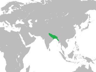
English: Map of the Sultanate of Bengal in Asia |
| 日期 | |
| 來源 |
At its greatest extent, the Bengal Sultanate's realm and protectorates stretched from Jaunpur in North India in the west to Tripura and Arakan in the east Source: Page 16, Perween Hasan (15 August 2007). Sultans and Mosques: The Early Muslim Architecture of Bangladesh. I.B.Tauris. 國際標準書號 978-1-84511-381-0. World Map used: File:BlankMap-World-noborders.png |
| 作者 | HistoryofBangladesh |
授權條款
| 這是一張修飾過的圖片,即本圖片是用軟體修改過後的版本,修改的方式或內容有:converted world map to SVG image and merged the two vector images to show the location of the Bengal Sultanate in Asia。原版圖片來源:BlankMap-World-noborders.png。修改者:Thayts。
|
此檔案採用創用CC 姓名標示-相同方式分享 4.0 國際授權條款。
- 您可以自由:
- 分享 – 複製、發佈和傳播本作品
- 重新修改 – 創作演繹作品
- 惟需遵照下列條件:
- 姓名標示 – 您必須指名出正確的製作者,和提供授權條款的連結,以及表示是否有對內容上做出變更。您可以用任何合理的方式來行動,但不得以任何方式表明授權條款是對您許可或是由您所使用。
- 相同方式分享 – 如果您利用本素材進行再混合、轉換或創作,您必須基於如同原先的相同或兼容的條款,來分布您的貢獻成品。
檔案歷史
點選日期/時間以檢視該時間的檔案版本。
| 日期/時間 | 縮圖 | 尺寸 | 使用者 | 備註 | |
|---|---|---|---|---|---|
| 目前 | 2016年10月2日 (日) 06:59 | | 327 × 246(19 KB) | HistoryofBangladesh | User created page with UploadWizard |
檔案用途
下列頁面有用到此檔案:
全域檔案使用狀況
以下其他 wiki 使用了這個檔案:
- azb.wikipedia.org 的使用狀況
- bn.wikipedia.org 的使用狀況
- en.wikipedia.org 的使用狀況
- Mosque City of Bagerhat
- Khan Jahan Ali
- Gauḍa (city)
- Pandua, Malda
- Mahmud Shah of Bengal
- Shamsuddin Ilyas Shah
- Saifuddin Hamza Shah
- Panbari Mosque
- Alauddin Husain Shah
- Shamsuddin Ahmad Shah
- Nuruddin Sikandar Shah
- Muhammad Khan Sur
- Sulaiman Khan Karrani
- Bayazid Khan Karrani
- Shihabuddin Bayazid Shah
- Ruknuddin Barbak Shah
- Ghiyasuddin Jalal Shah
- Bengal Sultanate
- Hussain Shahi dynasty
- Alaul Haq
- Usman Serajuddin
- Alauddin Firuz Shah II
- Battle of Rajmahal
- Bengal–Jaunpur confrontation
- Bengal Sultanate–Delhi Sultanate War
- Eklakhi Mausoleum
- Template:Bengal Sultanate
- Nasrat Gazi Mosque
- Qasba Mosque
- Template:Bengal Sultanate/doc
- Dobhashi
- User:Nafis Fuad Ayon
- Tanda, Bengal
- Muazzampur Shahi Mosque
- Nur Qutb Alam
- Danyal (Hussain Shahi dynasty)
- Ismail Khan Lodi
- Majidbaria Shahi Mosque
- fa.wikipedia.org 的使用狀況
- fi.wikipedia.org 的使用狀況
檢視此檔案的更多全域使用狀況。