File:TTC subway map 2018.svg

此 SVG 檔案的 PNG 預覽的大小:800 × 533 像素。 其他解析度:320 × 213 像素 | 640 × 427 像素 | 1,024 × 683 像素 | 1,280 × 853 像素 | 2,560 × 1,707 像素 | 3,150 × 2,100 像素。
原始檔案 (SVG 檔案,表面大小:3,150 × 2,100 像素,檔案大小:109 KB)
本檔案衍生自:
摘要
| 描述 |
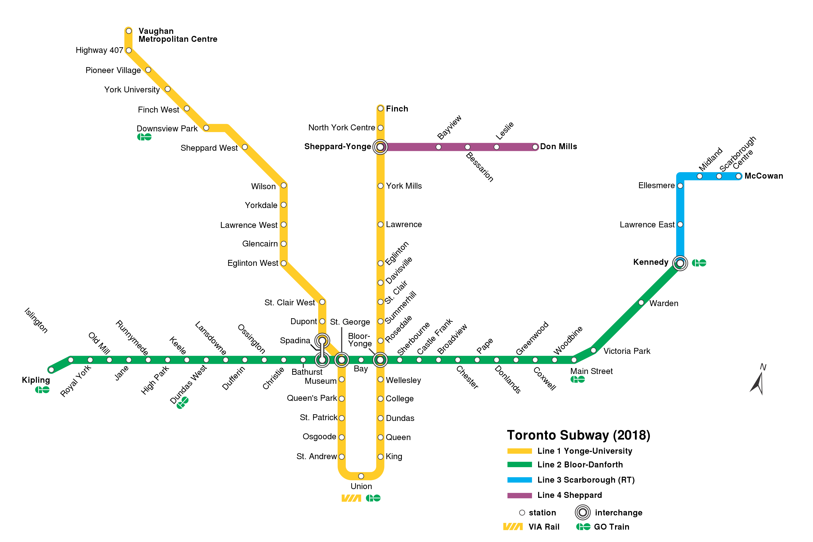
English: TTC subway/RT map (as of 2018); |
| 日期 | |
| 來源 | TTC_subway_map_2015.svg TTC_subway_map_2018.png |
| 作者 |
原作者: 向量: |
| 其他版本 |
|


授權條款
此檔案採用創用CC 姓名標示-相同方式分享 4.0 國際授權條款。
- 您可以自由:
- 分享 – 複製、發佈和傳播本作品
- 重新修改 – 創作演繹作品
- 惟需遵照下列條件:
- 姓名標示 – 您必須指名出正確的製作者,和提供授權條款的連結,以及表示是否有對內容上做出變更。您可以用任何合理的方式來行動,但不得以任何方式表明授權條款是對您許可或是由您所使用。
- 相同方式分享 – 如果您利用本素材進行再混合、轉換或創作,您必須基於如同原先的相同或兼容的條款,來分布您的貢獻成品。
檔案歷史
點選日期/時間以檢視該時間的檔案版本。
| 日期/時間 | 縮圖 | 尺寸 | 使用者 | 備註 | |
|---|---|---|---|---|---|
| 目前 | 2021年1月14日 (四) 03:56 | | 3,150 × 2,100(109 KB) | Blaixx | Fix spelling of "Centre" |
| 2020年12月26日 (六) 22:13 |  | 3,150 × 2,100(109 KB) | AquitaneHungerForce | St. Clair was labeled St. Clair West | |
| 2020年1月17日 (五) 16:04 |  | 3,150 × 2,100(106 KB) | AquitaneHungerForce | Added missing station name and completed vectorization process. Texted remaining station names. Cleaned up Spadina interchange. | |
| 2020年1月17日 (五) 15:28 |  | 3,150 × 2,100(153 KB) | AquitaneHungerForce | Fixed various spellings of "Sheppard" as pointed out by User:Transportfan70. | |
| 2019年12月16日 (一) 20:52 |  | 3,150 × 2,100(153 KB) | AquitaneHungerForce | Hand-vectorizes all the stops on lines 1 and 4, along with the Bay and Sherbourne stops on line 2. Moved a stray green square to the correct location. | |
| 2019年12月16日 (一) 19:57 |  | 3,150 × 2,100(166 KB) | AquitaneHungerForce | {{Information |description ={{en|1= TTC subway/RT map (as of 2018);}} |date =2019-12-16 |source =TTC_subway_map_2015.svg TTC_subway_map_2018.png |author =Transportfan70 Craftwerker }} Category:Public transport maps |
檔案用途
沒有使用此檔案的頁面。
全域檔案使用狀況
以下其他 wiki 使用了這個檔案:
- bn.wikipedia.org 的使用狀況
- ca.wikipedia.org 的使用狀況
- es.wikipedia.org 的使用狀況
- id.wikipedia.org 的使用狀況
- it.wikipedia.org 的使用狀況
- uk.wikipedia.org 的使用狀況
- uz.wikipedia.org 的使用狀況
- www.wikidata.org 的使用狀況