File:Tripura map.png
預覽大小:413 × 599 像素。 其他解析度:165 × 240 像素 | 331 × 480 像素 | 899 × 1,304 像素。
原始檔案 (899 × 1,304 像素,檔案大小:164 KB,MIME 類型:image/png)

|
本圖片是以PNG、GIF或JPEG格式上傳。然而,其中包含的資料或訊息,應該重新建立成可縮放向量圖形(SVG)檔案,以更有效率或更準確的方式儲存。如有可能,請上傳本圖片的SVG格式版本。在上傳之後,請修改維基各姊妹計畫中所有使用舊版圖片的條目(列在圖像連結章節中),替換為新版圖片,並在舊圖片的描述頁中加入{{Vector version available|新圖片名稱.svg}}模板,同時移除本模板。
|
摘要
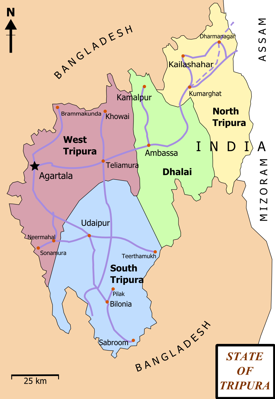
| 描述 | Map of State of Tripura. The map shows the former 4 districts of Tripura, with the state's roads and railway networks detailed. Railway was extended upto Agartala from Kumbarghat and opened by 2008.[1] |
| 日期 | |
| 來源 | 自己的作品 |
| 作者 | Wikigringo |
| 授權許可 (重用此檔案) |
attribution to author. |
| 其他版本 | Tripura locator map blank.svg.png |
| 標題 |
Tripura locator map |
| 描寫 |
Locator map of the state of Tripura, India with district boundaries. |
| 日期 | |
| 來源 |
自己的作品 |
| 創作作者 | |
| 授權許可 (重用此檔案) |
我,本作品的著作權持有者,決定用以下授權條款發佈本作品: 此檔案採用創用CC 姓名標示-相同方式分享 3.0 未在地化版本授權條款。
|
| Geotemporal data | |
| 描繪日期 | 20世紀下半期和21世紀 |
| 地理參考 | 如果不合適,請設定「warp_status = skip」為隱藏。 |
| Archival data | |
| 備註 | Part of WikiProject India Maps |
授權條款
我,本作品的著作權持有者,決定用以下授權條款發佈本作品:

|
已授權您依據自由軟體基金會發行的無固定段落、封面文字和封底文字GNU自由文件授權條款1.2版或任意後續版本,對本檔進行複製、傳播和/或修改。該協議的副本列在GNU自由文件授權條款中。 |
This file is licensed under the Creative Commons Attribution-Share Alike Attribution-Share Alike 4.0 International, 3.0 Unported, 2.5 Generic, 2.0 Generic and 1.0 Generic license.
- 您可以自由:
- 分享 – 複製、發佈和傳播本作品
- 重新修改 – 創作演繹作品
- 惟需遵照下列條件:
- 姓名標示 – 您必須指名出正確的製作者,和提供授權條款的連結,以及表示是否有對內容上做出變更。您可以用任何合理的方式來行動,但不得以任何方式表明授權條款是對您許可或是由您所使用。
- 相同方式分享 – 如果您利用本素材進行再混合、轉換或創作,您必須基於如同原先的相同或兼容的條款,來分布您的貢獻成品。
您可以選擇您需要的授權條款。
檔案歷史
點選日期/時間以檢視該時間的檔案版本。
| 日期/時間 | 縮圖 | 尺寸 | 使用者 | 備註 | |
|---|---|---|---|---|---|
| 目前 | 2012年2月15日 (三) 17:06 | | 899 × 1,304(164 KB) | Ras67 | cropped and optimized |
| 2008年2月27日 (三) 13:15 |  | 921 × 1,326(229 KB) | Wikigringo | {{Information |Description=Map of State of Tripura. Map shows the 4 districts of Tripura along with roadways and small railway network present in the state. |Source=self-made |Date=02/27/2008 |Author= Wikigringo |Permission=attribution |
檔案用途
下列頁面有用到此檔案:
全域檔案使用狀況
以下其他 wiki 使用了這個檔案:
- as.wikipedia.org 的使用狀況
- bn.wikipedia.org 的使用狀況
- ধর্মনগর
- কমলপুর
- ত্রিপুরা বিধানসভা নির্বাচন, ২০১৩
- ত্রিপুরা বিধানসভা নির্বাচন, ২০০৮
- ত্রিপুরা বিধানসভা নির্বাচন, ২০০৩
- ত্রিপুরা বিধানসভা নির্বাচন, ১৯৭২
- ত্রিপুরা বিধানসভা নির্বাচন, ১৯৭৭
- ত্রিপুরা বিধানসভা নির্বাচন, ১৯৮৩
- ত্রিপুরা বিধানসভা নির্বাচন, ১৯৮৮
- ত্রিপুরা বিধানসভা নির্বাচন, ১৯৯৩
- ত্রিপুরা বিধানসভা নির্বাচন, ১৯৯৮
- ca.wikipedia.org 的使用狀況
- en.wikipedia.org 的使用狀況
- Portal:India/Selected picture candidates
- Belonia, India
- User:Gppande/Album
- Portal:India/Selected picture candidates/Tripura district map
- 2008 Tripura Legislative Assembly election
- Wikipedia:Graphics Lab/Map workshop/Archive/Apr 2013
- Santirbazar
- 2003 Tripura Legislative Assembly election
- 1998 Tripura Legislative Assembly election
- 1993 Tripura Legislative Assembly election
- 1988 Tripura Legislative Assembly election
- 1983 Tripura Legislative Assembly election
- 1977 Tripura Legislative Assembly election
- 1972 Tripura Legislative Assembly election
- eu.wikipedia.org 的使用狀況
- fa.wikipedia.org 的使用狀況
- gom.wikipedia.org 的使用狀況
- hi.wikipedia.org 的使用狀況
- hr.wikipedia.org 的使用狀況
- incubator.wikimedia.org 的使用狀況
- kk.wikipedia.org 的使用狀況
- ml.wikipedia.org 的使用狀況
- ne.wikipedia.org 的使用狀況
- new.wikipedia.org 的使用狀況
- no.wikipedia.org 的使用狀況
檢視此檔案的更多全域使用狀況。