File:United States 1849-1850.png

預覽大小:800 × 542 像素。 其他解析度:320 × 217 像素 | 640 × 433 像素 | 1,000 × 677 像素。
原始檔案 (1,000 × 677 像素,檔案大小:95 KB,MIME 類型:image/png)
摘要
| 描述 |
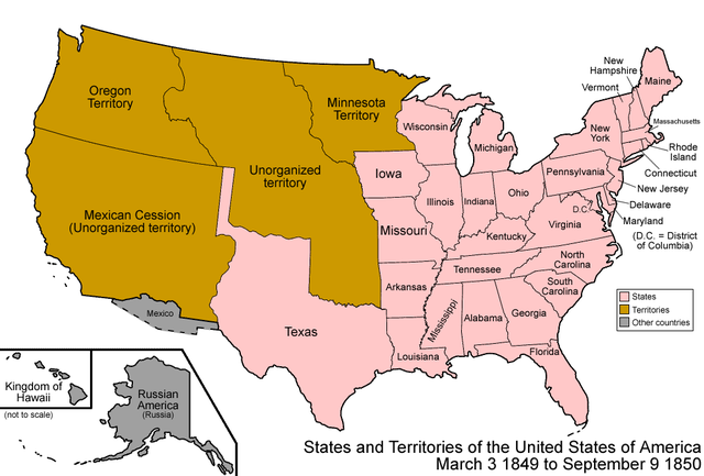
Map of the states and territories of the United States as it was from 1849 to 1850.
|
| 來源 | 自己的作品 |
| 作者 | Made by User:Golbez. See Charles O. Paullin and John K. Wright's Atlas of the Historical Geography of the United States (1932) for PD maps which support these. |
| 授權許可 (重用此檔案) |
Own work, attribution required (Multi-license with GFDL and Creative Commons CC-BY 2.5) |

|
本圖片是以PNG、GIF或JPEG格式上傳。然而,其中包含的資料或訊息,應該重新建立成可縮放向量圖形(SVG)檔案,以更有效率或更準確的方式儲存。如有可能,請上傳本圖片的SVG格式版本。在上傳之後,請修改維基各姊妹計畫中所有使用舊版圖片的條目(列在圖像連結章節中),替換為新版圖片,並在舊圖片的描述頁中加入{{Vector version available|新圖片名稱.svg}}模板,同時移除本模板。
|
授權條款
我,本作品的著作權持有者,決定用以下授權條款發佈本作品:

|
已授權您依據自由軟體基金會發行的無固定段落、封面文字和封底文字GNU自由文件授權條款1.2版或任意後續版本,對本檔進行複製、傳播和/或修改。該協議的副本列在GNU自由文件授權條款中。 |
| 此檔案採用創用CC 姓名標示-相同方式分享 3.0 未在地化版本授權條款。 | ||
| ||
| 已新增授權條款標題至此檔案,作為GFDL授權更新的一部份。 |
此檔案採用創用CC 姓名標示 2.5 通用版授權條款。
- 您可以自由:
- 分享 – 複製、發佈和傳播本作品
- 重新修改 – 創作演繹作品
- 惟需遵照下列條件:
- 姓名標示 – 您必須指名出正確的製作者,和提供授權條款的連結,以及表示是否有對內容上做出變更。您可以用任何合理的方式來行動,但不得以任何方式表明授權條款是對您許可或是由您所使用。
您可以選擇您需要的授權條款。
| Territorial evolution maps of the United States |
| v · d (template shows date of beginning of change yyyy-mm-dd) |
| 1789-03, 1789-08, 1790-04, 1790-05, 1791-03, 1791-09, 1792-03, 1792-06, 1795, 1796, 1798, 1800-07-04, 1800-07, 1802, 1803-03, 1803-04, 1804-03, 1804-10, 1805-01, 1805-07, 1809, 1810-04, 1810-10, 1812-04, 1812-05, 1812-06, 1816, 1817-03, 1817-12, 1818-10, 1818-12, 1819-03, 1819-12, 1820, 1821-07, 1821, 1822, 1824, 1828, 1834, 1836-03, 1836-06, 1836-07, 1837-01, 1837-03, 1838, 1842, 1845-03, 1845-12, 1846-06, 1846-12, 1848-02, 1848-05, 1848-08, 1849, 1850, 1853-03, 1853-12, 1854, 1858, 1859, 1860, 1861-01, 1861-02-04, 1861-02-28, 1861-03, 1861-08, 1862, 1863-02, 1863-03, 1863-06, 1864-05, 1864-10, 1865, 1866, 1867-01, 1867-03, 1867-10, 1868, 1876, 1884, 1889-11-02, 1889-11-08, 1889-11-11, 1890-05, 1890-07-03, 1890-07-10, 1896-01, 1896-05, 1898, 1907, 1912-01, 1912-02, 1912-08, 1959-01, 1959-08 |
檔案歷史
點選日期/時間以檢視該時間的檔案版本。
| 日期/時間 | 縮圖 | 尺寸 | 使用者 | 備註 | |
|---|---|---|---|---|---|
| 目前 | 2006年7月29日 (六) 07:04 | | 1,000 × 677(95 KB) | Golbez | {{Information| |Description=Map of the states and territories of the United States as it was from |Source= |Date= |Author=Made by User:Golbez. |Permission=Own work, attribution required (Multi-license with GFDL and Creative Commons CC-BY 2.5) |other_ |
檔案用途
下列2個頁面有用到此檔案:
全域檔案使用狀況
以下其他 wiki 使用了這個檔案:
- ar.wikipedia.org 的使用狀況
- bg.wikipedia.org 的使用狀況
- ca.wikipedia.org 的使用狀況
- cs.wikipedia.org 的使用狀況
- da.wikipedia.org 的使用狀況
- de.wikipedia.org 的使用狀況
- en.wikipedia.org 的使用狀況
- James K. Polk
- Compromise of 1850
- Henry Clay
- Sam Houston
- Southwestern United States
- Talk:List of U.S. states by date of admission to the Union
- Presidency of James K. Polk
- Presidency of Millard Fillmore
- Zachary Taylor
- Stephen A. Douglas
- History of United States foreign policy
- History of U.S. foreign policy, 1829–1861
- es.wikipedia.org 的使用狀況
- fa.wikipedia.org 的使用狀況
- fr.wikipedia.org 的使用狀況
- he.wikipedia.org 的使用狀況
- hy.wikipedia.org 的使用狀況
- it.wikipedia.org 的使用狀況
- ja.wikipedia.org 的使用狀況
- nl.wikipedia.org 的使用狀況
- no.wikipedia.org 的使用狀況
- pt.wikipedia.org 的使用狀況
- ru.wikipedia.org 的使用狀況
- vi.wikipedia.org 的使用狀況