File:WW2-Holocaust-Europe.png

原始檔案 (1,310 × 1,090 像素,檔案大小:639 KB,MIME 類型:image/png)
摘要
| 描述 |
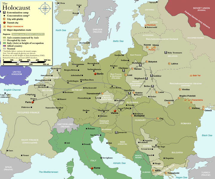
Map of the Holocaust in Europe during World War II, 1939-1945.
|
| 日期 | |
| 來源 | Self-made by User:Dna-Dennis, using information from USHMM & Wikipedia. |
| 作者 | User:Dna-Dennis |
| 授權許可 (重用此檔案) |
CC, see below. The map is completely unrestricted for any Wikipedia/Wikimedia project. |
| 其他版本 |
[]
|


.png)


.png)


.png)

|
File:WW2 Holocaust Europe map-fr.svg是本檔案的向量版本。 如果品質不低,就應該優先使用該檔案,而非PNG檔案。
File:WW2-Holocaust-Europe.png → File:WW2 Holocaust Europe map-fr.svg
更多資訊請參閱Help:SVG/zh。 |
 |
授權條款
- 您可以自由:
- 分享 – 複製、發佈和傳播本作品
- 重新修改 – 創作演繹作品
- 惟需遵照下列條件:
- 姓名標示 – 您必須指名出正確的製作者,和提供授權條款的連結,以及表示是否有對內容上做出變更。您可以用任何合理的方式來行動,但不得以任何方式表明授權條款是對您許可或是由您所使用。
檔案歷史
點選日期/時間以檢視該時間的檔案版本。
| 日期/時間 | 縮圖 | 尺寸 | 使用者 | 備註 | |
|---|---|---|---|---|---|
| 目前 | 2009年10月29日 (四) 13:57 | | 1,310 × 1,090(639 KB) | Flying Saucer | moved Vaivara to it's right place |
| 2007年12月20日 (四) 03:41 |  | 1,310 × 1,090(826 KB) | Dna-webmaster~commonswiki | new version without "Axis cooperating" in legend | |
| 2007年12月20日 (四) 02:00 |  | 1,310 × 1,090(824 KB) | Dna-webmaster~commonswiki | Now entire West Prussia and Wartheland is included in the Third Reich | |
| 2007年12月19日 (三) 16:42 |  | 1,310 × 1,090(828 KB) | Dna-webmaster~commonswiki | still not Da Vinci, but errors have been corrected (Germany borders West/East), West & East Prussia borders/coloring and Poland General Government corrected borders. | |
| 2007年12月17日 (一) 10:46 |  | 1,310 × 1,090(825 KB) | Dna-webmaster~commonswiki | new map with 1942 borders, not Da Vinci, but here it goes... | |
| 2007年10月19日 (五) 13:32 |  | 1,310 × 1,090(766 KB) | Dna-webmaster~commonswiki | and another update | |
| 2007年10月19日 (五) 12:21 |  | 1,310 × 1,090(771 KB) | Dna-webmaster~commonswiki | quick fix | |
| 2007年10月19日 (五) 12:11 |  | 1,310 × 1,090(771 KB) | Dna-webmaster~commonswiki | {{Information |Description=Map of the Holocaust in Europe during World War II, 1939-1945. <br> This map shows all extermination camps (or ''death camps''), most major concentration camps, work camps, prison camps, ghettos, major deportation routes and maj |
檔案用途
全域檔案使用狀況
以下其他 wiki 使用了這個檔案:
- af.wikipedia.org 的使用狀況
- ar.wikipedia.org 的使用狀況
- az.wikipedia.org 的使用狀況
- be-tarask.wikipedia.org 的使用狀況
- be.wikipedia.org 的使用狀況
- bn.wikipedia.org 的使用狀況
- ca.wikipedia.org 的使用狀況
- cs.wikipedia.org 的使用狀況
- de.wikipedia.org 的使用狀況
- el.wikipedia.org 的使用狀況
- en.wikipedia.org 的使用狀況
- Auschwitz concentration camp
- Extermination camp
- Sobibor extermination camp
- Drancy internment camp
- White Buses
- Vel' d'Hiv Roundup
- Template:Image frame
- German war crimes
- René Bousquet
- Holocaust trains
- Portal:Genocide/Selected article
- Portal:Genocide/Selected article/8
- Mechelen transit camp
- User:Dna-webmaster/Projects
- Jewish ghettos in Europe
- List of Jewish ghettos in Europe during World War II
- Template:Image frame/doc
- User:Jnestorius/Resources
- Wikipedia:Featured picture candidates/January-2015
- Wikipedia:Featured picture candidates/Map of the Holocaust in Europe
- The Holocaust in Hungary
- Emigration of Jews from Nazi Germany and German-occupied Europe
- Talk:The Holocaust/Archive 31
- Template:Image frame/sandbox
- Reich Security Head Office Referat IV B4
- Genocides in history (World War I through World War II)
- User:Buidhe/fork
- en.wikibooks.org 的使用狀況
- es.wikipedia.org 的使用狀況
- fa.wikipedia.org 的使用狀況
- fi.wikipedia.org 的使用狀況
- fi.wikibooks.org 的使用狀況
- fr.wikipedia.org 的使用狀況
檢視此檔案的更多全域使用狀況。