File:Amazon-river-NASA.jpg

預覽大小:600 × 600 像素。 其他解析度:240 × 240 像素 | 480 × 480 像素 | 768 × 768 像素 | 1,024 × 1,024 像素 | 2,048 × 2,048 像素 | 4,096 × 4,096 像素。
原始檔案 (4,096 × 4,096 像素,檔案大小:2.79 MB,MIME 類型:image/jpeg)
摘要
| 描述 |
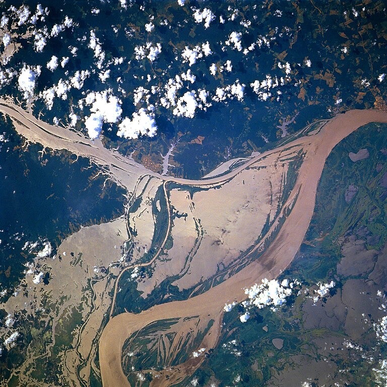
Afrikaans: STS078-751-094 Oorstroomde Amasonerivieroewers in westelike Pará-provinsie, Brasilië in Junie 1996. Die ligging is sowat halfpad tussen Manaus en die Amasonerivierdelta.
Hierdie beeld toon oorstroomde oewers van 'n klein segment van die Amasonerivier, insluitend die oerwouddorpies Oriximiná en Óbidos. Songlans op die modderige rivierwater fasiliteer die onderskeiding van land en water. Deur hierdie beeld met 'n gedetailleerde gebiedskaart te vergelyk, word dit duidelik dat die Amazonerivier sy oewers in die laagliggende dele aanliggend aan die vloedvlakte van die hoofkanaal oorstroom, en groot dele suid van die hoofkanaal staan ook onder (skoon) water. Ontbosde gebiede is binne die digbegroeide terrein aan die noordekant van die Amasonerivier waarneembaar. Die hoofkanaal van die Trombetasrivier kan suidooswaarts nagespeur word, van die linkerrand van die prent af, totdat die Trombetas tussen die oerwouddorpies Oriximiná en Óbidos met die Amasone saamvloei. English: A satellite image of a part of the Amazon River.
Esperanto: La bildo estas kopiita de wikipedia:en. La originala priskribo estas
English: Original caption: [altered to reflect rotation]
|
| 日期 | |
| 來源 | http://earth.jsc.nasa.gov/sseop/EFS/photoinfo.pl?PHOTO=STS078-751-94 (file) |
| 作者 | NASA |
| 目標地點 | | 位於此地的本圖片與其他圖片: OpenStreetMap |
|---|
本圖像或影音收錄於美國國家航空暨太空總署 (NASA)某部門,其照片編號為: STS078-751-94 此標籤不表示文件的著作權狀態。任何文件在附有此標籤的同時還需要一個有效的著作權標籤。請參閱許可協議說明頁面以了解更多資訊。 其他語言:
|
授權條款
| 本作品由NASA創作,屬於公有領域。根據NASA的版權政策:“NASA的創作除非另有聲明否則不受版權保護。”(參見:Template:PD-USGov/zh,NASA版權政策或JPL圖像使用政策) | ||
 |
警告:
|
Old file history
Transferred from English-Wikipedia:
| date/time | username | edit summary |
|---|---|---|
| 02:26, 6 January 2005 | en:User:Quadell | (tagged) |
| 18:08, 18 June 2004 | en:User:Sverdrup | (Image info) |
| 18:06, 18 June 2004 | en:User:Sverdrup | (A satellite image of a part of the <a href="/wiki/Amazon_River" title="Amazon River">Amazon River</a>) |
| 註解 | 該圖片含有註解:在維基媒體共享資源上查看註解 |
檔案歷史
點選日期/時間以檢視該時間的檔案版本。
| 日期/時間 | 縮圖 | 尺寸 | 用戶 | 備註 | |
|---|---|---|---|---|---|
| 目前 | 2022年12月8日 (四) 17:13 | | 4,096 × 4,096(2.79 MB) | JMK | boost saturation, add some contrast |
| 2022年12月8日 (四) 17:10 |  | 4,096 × 4,096(2.69 MB) | JMK | rotate 180, north up | |
| 2022年11月10日 (四) 10:10 |  | 4,096 × 4,096(15.22 MB) | Askeuhd | Higher resolution version | |
| 2012年10月10日 (三) 14:15 |  | 640 × 640(418 KB) | Rotatebot | Bot: Image rotated by 180° | |
| 2006年1月29日 (日) 14:39 |  | 640 × 640(377 KB) | Maksim | La bildo estas kopiita de wikipedia:en. La originala priskribo estas: A satellite image of a part of the Amazon River. {{PD-USGov-NASA}} '''Original caption:''' :''STS078-751-094 Amazon River, Western Para Province, Brazil June 1996'' :''This image s |
檔案用途
下列頁面有用到此檔案:
全域檔案使用狀況
以下其他 wiki 使用了這個檔案:
- ar.wikipedia.org 的使用狀況
- ast.wikipedia.org 的使用狀況
- azb.wikipedia.org 的使用狀況
- ca.wikipedia.org 的使用狀況
- ce.wikipedia.org 的使用狀況
- cv.wikipedia.org 的使用狀況
- en.wikipedia.org 的使用狀況
- eo.wikipedia.org 的使用狀況
- es.wikipedia.org 的使用狀況
- eu.wikipedia.org 的使用狀況
- fa.wikipedia.org 的使用狀況
- fr.wikipedia.org 的使用狀況
- fy.wikipedia.org 的使用狀況
- id.wikipedia.org 的使用狀況
- ilo.wikipedia.org 的使用狀況
- kk.wikipedia.org 的使用狀況
- krc.wikipedia.org 的使用狀況
- ml.wikipedia.org 的使用狀況
- mr.wikipedia.org 的使用狀況
- nl.wikipedia.org 的使用狀況
- no.wikipedia.org 的使用狀況
- os.wikipedia.org 的使用狀況
- pl.wiktionary.org 的使用狀況
- pt.wikipedia.org 的使用狀況
- rm.wikipedia.org 的使用狀況
- ru.wikipedia.org 的使用狀況
- uk.wikipedia.org 的使用狀況
- vec.wikipedia.org 的使用狀況
- vi.wikipedia.org 的使用狀況
- www.wikidata.org 的使用狀況
- zh-yue.wikipedia.org 的使用狀況