File:Bananal-Island-North-End-Landsat-25-07-1992.png

預覽大小:600 × 600 像素。 其他解析度:240 × 240 像素 | 480 × 480 像素 | 768 × 768 像素 | 1,024 × 1,024 像素。
原始檔案 (1,024 × 1,024 像素,檔案大小:610 KB,MIME 類型:image/png)
摘要
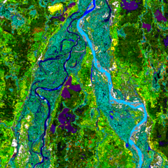
| 描述 | Landsat image of the northern end of Bananal Island, Brazil |
| 日期 | |
| 來源 | Landsat http://www.geog.ucsb.edu/~rivers/sa/bananal-web/cluster50.gif |
| 作者 | Landsat 5, US Government |
| 授權許可 (重用此檔案) |
Public Domain |
授權條款
本圖像屬於公有領域,因該作品最初來自於美國國家海洋和大氣管理局職員的職務作品。
|
原始上傳日誌
| 日期/時間 | 尺寸 | 用戶 | 備註 |
|---|---|---|---|
| 2006年八月15日, 21:25:13 | 1024 × 1024 (508177 bytes) | Bejnar (對話 · 貢獻) | {{Information |Description=Landsat image of the northern end of Bananal Island |Source=Landsat http://www.geog.ucsb.edu/~rivers/sa/bananal-web/cluster50.gif |Date= 25 July 1992 |Author= Landsat 5, US Government |Permission=Public Domain |other_versions= } |
檔案歷史
點選日期/時間以檢視該時間的檔案版本。
| 日期/時間 | 縮圖 | 尺寸 | 用戶 | 備註 | |
|---|---|---|---|---|---|
| 目前 | 2014年8月23日 (六) 10:09 | | 1,024 × 1,024(610 KB) | GifTagger | Bot: Converting file to superior PNG file. (Source: Bananal-Island-North-End-Landsat-25-07-1992.gif). This GIF was problematic due to non-greyscale color table. |
檔案用途
下列頁面有用到此檔案:
全域檔案使用狀況
以下其他 wiki 使用了這個檔案:
- af.wikipedia.org 的使用狀況
- ca.wikipedia.org 的使用狀況
- cs.wikipedia.org 的使用狀況
- en.wikipedia.org 的使用狀況
- eo.wikipedia.org 的使用狀況
- es.wikipedia.org 的使用狀況
- fa.wikipedia.org 的使用狀況
- fi.wikipedia.org 的使用狀況
- gl.wikipedia.org 的使用狀況
- he.wikipedia.org 的使用狀況
- id.wikipedia.org 的使用狀況
- it.wikipedia.org 的使用狀況
- ja.wikipedia.org 的使用狀況
- ko.wikipedia.org 的使用狀況
- nl.wikipedia.org 的使用狀況
- pl.wikipedia.org 的使用狀況
- pt.wikipedia.org 的使用狀況
- ro.wikipedia.org 的使用狀況
- sl.wikipedia.org 的使用狀況
- sr.wikipedia.org 的使用狀況
- vi.wikipedia.org 的使用狀況
- war.wikipedia.org 的使用狀況
- www.wikidata.org 的使用狀況