File:Crossroads Baker Target Ship Map.png
此為最大尺寸。
Crossroads_Baker_Target_Ship_Map.png (500 × 500 像素,檔案大小:17 KB,MIME 類型:image/png)

|
本圖片是以PNG、GIF或JPEG格式上傳。然而,其中包含的資料或訊息,應該重新建立成可縮放向量圖形(SVG)檔案,以更有效率或更準確的方式儲存。如有可能,請上傳本圖片的SVG格式版本。在上傳之後,請修改維基各姊妹計畫中所有使用舊版圖片的條目(列在圖像連結章節中),替換為新版圖片,並在舊圖片的描述頁中加入{{Vector version available|新圖片名稱.svg}}模板,同時移除本模板。
|
Image converted from .gif to .png with no changes.
摘要
| 描述 |
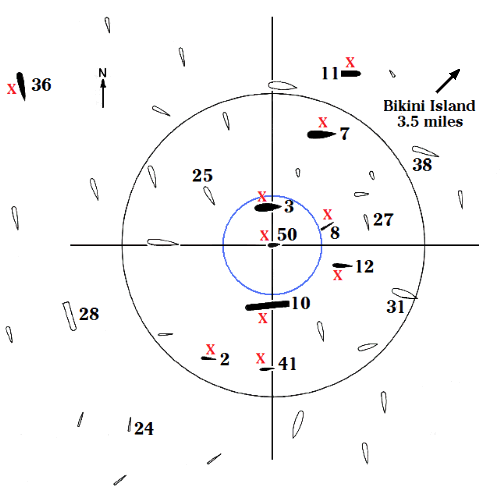
English: The array of target ships in Bikini lagoon for the Baker shot of Operation Crossroads, July, 25, 1946. The ten red X's mark the ten ships that sank. The black circle, with a radius of 1,000 yards from the point of detonation, outlines the area of serious ship damage. The blue circle, 330-yard radius, marks the rim of the shallow underwater crater created by the blast, as well as the circumference of the hollow water column which capsized the Arkansas. The submarines were submerged, the Pilotfish, ship #8, to a keel depth of 56 feet, and the Apogon, ship # 2, to a keel depth of 100 feet. |
| 日期 | |
| 來源 | Own work by uploader. Data in the map come from Delgado, James P., et al., The Archeology of the Atomic Bomb, National Park Service, Santa Fe, New Mexico, 1991. The Able map is on p 16, the Baker map on p 17, and ship damage and distances on pp 86-136. The full text of this reference is posted on the Internet.[1] |
| 作者 | HowardMorland |
授權條款
| 我,此作品的版權所有人,釋出此作品至公共領域。此授權條款在全世界均適用。 這可能在某些國家不合法,如果是的話: 我授予任何人有權利使用此作品於任何用途,除受法律約束外,不受任何限制。 |
檔案歷史
點選日期/時間以檢視該時間的檔案版本。
| 日期/時間 | 縮圖 | 尺寸 | 用戶 | 備註 | |
|---|---|---|---|---|---|
| 目前 | 2008年12月8日 (一) 02:58 | | 500 × 500(17 KB) | HowardMorland | Image converted from .gif to .png with no changes. <!--{{ImageUpload|basic}}--> |
檔案用途
下列頁面有用到此檔案:
全域檔案使用狀況
以下其他 wiki 使用了這個檔案:
- de.wikipedia.org 的使用狀況
- en.wikipedia.org 的使用狀況
- es.wikipedia.org 的使用狀況
- it.wikipedia.org 的使用狀況
- pt.wikipedia.org 的使用狀況
- ru.wikipedia.org 的使用狀況
- tr.wikipedia.org 的使用狀況
- uk.wikipedia.org 的使用狀況