File:EasternSolomonsChart.jpg
預覽大小:559 × 599 像素。 其他解析度:224 × 240 像素 | 448 × 480 像素 | 640 × 686 像素。
原始檔案 (640 × 686 像素,檔案大小:90 KB,MIME 類型:image/jpeg)
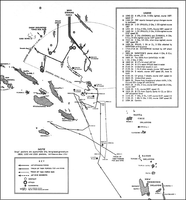
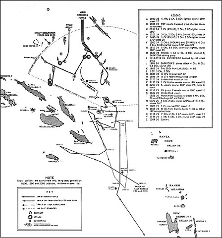
| 描述 | US Navy map of The Battle of the Eastern Solomons. Tracks of Allied (U.S.) forces are most likely fairly accurate. Tracks of Japanese forces are approximate and/or conjectured. The term "Jap" is used as shorthand for "Japanese" on the map. It's unknown whether this was used pejoratively in this publication or as an accepted abbreviation at that time. |
| 日期 | |
| 來源 | US Government ( http://www.ibiblio.org/hyperwar/USN/USN-CN-ESols/index.html )The Battle of the Eastern Solomons, 23-25 August 1942, Navy Department Office of Naval Intelligence, Combat Narrative |
| 作者 | US Government |
| 授權許可 (重用此檔案) |
US Government/public domain |
 | ||
| 此作品無已知的著作權限制,亦不受所有相關和鄰接的權利限制。 | ||
檔案歷史
點選日期/時間以檢視該時間的檔案版本。
| 日期/時間 | 縮圖 | 尺寸 | 用戶 | 備註 | |
|---|---|---|---|---|---|
| 目前 | 2006年5月24日 (三) 16:12 | | 640 × 686(90 KB) | Cla68 | {{Information| |Description= US Navy map of The Battle of the Eastern Solomons. This map may not be entirely accurate since it was published before World War II was over. |Source= US Government (http://www.ibiblio.org/hyperwar/USN/USN-CN-ESols/index.html |
檔案用途
下列頁面有用到此檔案:
全域檔案使用狀況
以下其他 wiki 使用了這個檔案:
- azb.wikipedia.org 的使用狀況
- cs.wikipedia.org 的使用狀況
- da.wikipedia.org 的使用狀況
- en.wikipedia.org 的使用狀況
- es.wikipedia.org 的使用狀況
- fr.wikipedia.org 的使用狀況
- he.wikipedia.org 的使用狀況
- hu.wikipedia.org 的使用狀況
- id.wikipedia.org 的使用狀況
- ko.wikipedia.org 的使用狀況
- nl.wikipedia.org 的使用狀況
- sr.wikipedia.org 的使用狀況
- vi.wikipedia.org 的使用狀況