File:Elevation.jpg

預覽大小:800 × 400 像素。 其他解析度:320 × 160 像素 | 640 × 320 像素 | 1,024 × 512 像素 | 1,280 × 640 像素 | 2,560 × 1,280 像素 | 10,800 × 5,400 像素。
原始檔案 (10,800 × 5,400 像素,檔案大小:25.61 MB,MIME 類型:image/jpeg)
摘要
| 描述 |
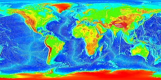
English: Global land and undersea elevation. (flat projection
Deutsch: Globales Höhenprofil (Flachkarte) |
| 日期 | 日期不明 |
| 來源 | http://www.ngdc.noaa.gov/mgg/image/2minrelief.html |
| 作者 | National Oceanic and Atmospheric Administration |
To calculate geografic coordinates to map coordinates: X = (180 + longitude) * width of map / 360 // west is minus Y = (90 + latitude) * height of map / 360 // north is minus
授權條款
本圖像屬於公有領域,因該作品最初來自於美國國家海洋和大氣管理局職員的職務作品。
|
![]()
See also
- Image:LARGE elevation.jpg — a high-resolution (13MB) version of this image
- Image:Earth surface NGDC 2000.jpg — made from similar data
檔案歷史
點選日期/時間以檢視該時間的檔案版本。
| 日期/時間 | 縮圖 | 尺寸 | 用戶 | 備註 | |
|---|---|---|---|---|---|
| 目前 | 2023年8月19日 (六) 20:02 | | 10,800 × 5,400(25.61 MB) | Kersti Nebelsiek | higher resolution |
| 2021年11月13日 (六) 23:11 |  | 5,400 × 2,700(14.08 MB) | Antonsusi | resolution | |
| 2006年3月7日 (二) 01:59 |  | 4,320 × 2,160(1.86 MB) | Interiot~commonswiki | Global land and undersea elevation. Source: http://www.ngdc.noaa.gov/mgg/image/2minrelief.html |
檔案用途
全域檔案使用狀況
以下其他 wiki 使用了這個檔案:
- af.wikipedia.org 的使用狀況
- an.wikipedia.org 的使用狀況
- ar.wikipedia.org 的使用狀況
- ast.wikipedia.org 的使用狀況
- awa.wikipedia.org 的使用狀況
- az.wikipedia.org 的使用狀況
- ba.wikipedia.org 的使用狀況
- be-tarask.wikipedia.org 的使用狀況
- be.wikipedia.org 的使用狀況
- bg.wikipedia.org 的使用狀況
- bh.wikipedia.org 的使用狀況
- br.wikipedia.org 的使用狀況
- bs.wikipedia.org 的使用狀況
- ca.wikipedia.org 的使用狀況
- ce.wikipedia.org 的使用狀況
- ckb.wikipedia.org 的使用狀況
- cs.wikipedia.org 的使用狀況
- da.wikipedia.org 的使用狀況
- de.wikipedia.org 的使用狀況
- el.wikipedia.org 的使用狀況
- en.wikipedia.org 的使用狀況
- en.wikiversity.org 的使用狀況
- eo.wikipedia.org 的使用狀況
- es.wikipedia.org 的使用狀況
- et.wikipedia.org 的使用狀況
- eu.wikipedia.org 的使用狀況
- fa.wikipedia.org 的使用狀況
- fi.wikipedia.org 的使用狀況
- fr.wikipedia.org 的使用狀況
- ga.wikipedia.org 的使用狀況
檢視此檔案的更多全域使用狀況。