File:Kashmir region. LOC 2003626427 - showing sub-regions administered by different countries.jpg

預覽大小:560 × 599 像素。 其他解析度:224 × 240 像素 | 448 × 480 像素 | 718 × 768 像素 | 957 × 1,024 像素 | 1,914 × 2,048 像素 | 4,597 × 4,920 像素。
原始檔案 (4,597 × 4,920 像素,檔案大小:6 MB,MIME 類型:image/jpeg)
摘要
| 描述 |
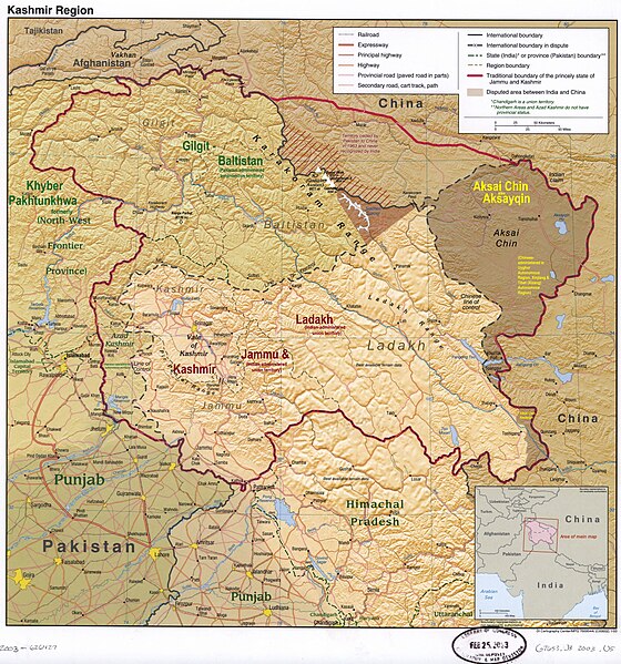
English: The disputed Kashmir region, showing the sub-regions administered by India, Pakistan, and China |
| 日期 | |
| 來源 | https://upload.wikimedia.org/wikipedia/commons/8/8f/Kashmir_region._LOC_2003626427.jpg |
| 作者 | US Central Intelligence Agency (old labels removed, new added by Fowler&fowler (對話) 02:56, 11 April 2022 (UTC)) |
| 其他版本 |
 |
授權條款
此作品在美國屬於公有領域,因為其是由美國政府的官員或僱員,基於其個人公務目的製作的作品,參考美國法典第17篇第1章第105條。
注意︰本模板僅適用於美國聯邦政府的原創作品,不適用於任何美國州、屬地、聯邦個體、縣、市或任何次級政府的作品。本模板也不適用於1978年以後由美國郵政署出版的郵票圖案(參看美國版權局實踐綱領第313.6(C)(1)條)。也不適用於部分美國硬幣;參看美國鑄幣局使用條款。 |
 | |
| 此作品無已知的著作權限制,亦不受所有相關和鄰接的權利限制。 | ||
檔案歷史
點選日期/時間以檢視該時間的檔案版本。
| 日期/時間 | 縮圖 | 尺寸 | 用戶 | 備註 | |
|---|---|---|---|---|---|
| 目前 | 2023年7月4日 (二) 02:31 | | 4,597 × 4,920(6 MB) | Fowler&fowler | Reverted to version as of 14:18, 12 April 2022 (UTC) |
| 2023年6月24日 (六) 14:46 |  | 4,597 × 4,920(3.74 MB) | Geographyinitiative | There is no evidence that Demchok sector is part of Aksai Chin. The original map is good enough and the yellow scribbles attempt to steal the authority of the professional cartographers. | |
| 2022年4月12日 (二) 14:18 |  | 4,597 × 4,920(6 MB) | Fowler&fowler | Added Peaks | |
| 2022年4月11日 (一) 02:56 |  | 4,597 × 4,920(6 MB) | Fowler&fowler | Uploaded a work by US Central Intelligence Agency (old labels removed, new added by ~~~~) from https://upload.wikimedia.org/wikipedia/commons/8/8f/Kashmir_region._LOC_2003626427.jpg with UploadWizard |
檔案用途
沒有使用此檔案的頁面。
全域檔案使用狀況
以下其他 wiki 使用了這個檔案:
- ar.wikipedia.org 的使用狀況
- en.wikipedia.org 的使用狀況
- Azad Kashmir
- Kashmir
- Aksai Chin
- Ladakh
- Gilgit
- Skardu
- Muzaffarabad
- Bagh District
- Bhimber District
- Kotli District
- Muzaffarabad District
- Poonch District, Pakistan
- Mirpur District
- Insurgency in Jammu and Kashmir
- Kashmir conflict
- Kargil
- Proposed states and union territories of India
- Chilas
- Ghanche District
- Skardu District
- Gilgit District
- Astore District
- Sudhanoti District
- Neelum District
- Jammu and Kashmir (princely state)
- Gilgit-Baltistan
- Haveli District
- Hattian Bala District
- Nagar District
- Roundu District
- Exodus of Kashmiri Hindus
- Shigar District
- Kharmang District
- Hunza District
- Gilgit Division
- Baltistan Division
- Diamer Division
- Gupis-Yasin District
- Jammu and Kashmir (union territory)
- Revocation of the special status of Jammu and Kashmir
- Darel District
- Ghizer District (2019–)
- Talk:Himalayas/Archive 5
- Talk:Srinagar/Archive 1
- User:Falcaorib/India and Pakistan
- fa.wikipedia.org 的使用狀況
- kn.wikipedia.org 的使用狀況
- ks.wikipedia.org 的使用狀況
檢視此檔案的更多全域使用狀況。