原始檔案(2,700 × 2,004 像素,檔案大小:342 KB,MIME 類型:image/png


摘要

描述
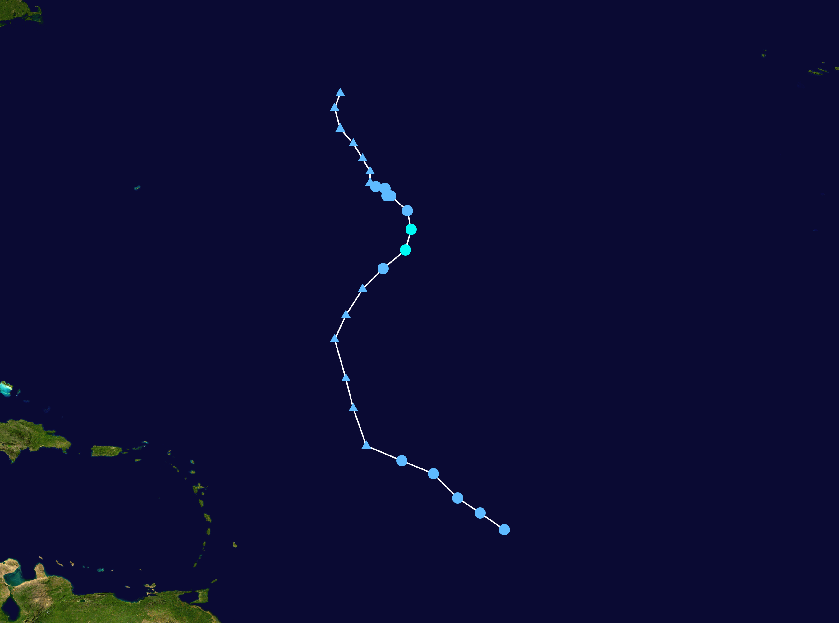
English: Track map of Tropical Storm Lee of the 2005 Atlantic hurricane season. The points show the location of the storm at 6-hour intervals. The colour represents the storm's maximum sustained wind speeds as classified in the (see below), and the shape of the data points represent the nature of the storm, according to the legend below.
 
Tropical depression (≤38 mph, ≤62 km/h)
 
Tropical storm (39–73 mph, 63–118 km/h)
 
Category 1 (74–95 mph, 119–153 km/h)
 
Category 2 (96–110 mph, 154–177 km/h)
 
Category 3 (111–129 mph, 178–208 km/h)
 
Category 4 (130–156 mph, 209–251 km/h)
 
Category 5 (≥157 mph, ≥252 km/h)
 
Unknown

Storm type

▲ Extratropical cyclone / Remnant low / Tropical disturbance / Monsoon depression
日期 2005-08-28–2005-09-03
來源 Created by Supportstorm using Wikipedia:WikiProject Tropical cyclones/Tracks. The background image is from NASA. Tracking data is from the National Hurricane Center[1].
作者 Supportstorm
Source code
InfoField
Track map data table, if present below, is in HURDAT2 or ATCF format. See format details in [2] and [3], respectively.
Track map generator input code
AL132005,                LEE,     26,
20050828, 1200,  , TD, 14.0N,  45.1W,  25, 1009,    0,    0,    0,    0,    0,    0,    0,    0,    0,    0,    0,    0,     NHC,
20050828, 1800,  , TD, 14.9N,  46.4W,  25, 1007,    0,    0,    0,    0,    0,    0,    0,    0,    0,    0,    0,    0,     NHC,
20050829, 0000,  , TD, 15.7N,  47.6W,  25, 1007,    0,    0,    0,    0,    0,    0,    0,    0,    0,    0,    0,    0,     NHC,
20050829, 0600,  , TD, 17.0N,  48.9W,  25, 1007,    0,    0,    0,    0,    0,    0,    0,    0,    0,    0,    0,    0,     NHC,
20050829, 1200,  , TD, 17.7N,  50.6W,  25, 1008,    0,    0,    0,    0,    0,    0,    0,    0,    0,    0,    0,    0,     NHC,
20050829, 1800,  , LO, 18.5N,  52.5W,  20, 1009,    0,    0,    0,    0,    0,    0,    0,    0,    0,    0,    0,    0,     NHC,
20050830, 0000,  , LO, 20.5N,  53.2W,  20, 1010,    0,    0,    0,    0,    0,    0,    0,    0,    0,    0,    0,    0,     NHC,
20050830, 0600,  , LO, 22.1N,  53.6W,  20, 1010,    0,    0,    0,    0,    0,    0,    0,    0,    0,    0,    0,    0,     NHC,
20050830, 1200,  , LO, 24.2N,  54.2W,  20, 1010,    0,    0,    0,    0,    0,    0,    0,    0,    0,    0,    0,    0,     NHC,
20050830, 1800,  , LO, 25.5N,  53.6W,  25, 1010,    0,    0,    0,    0,    0,    0,    0,    0,    0,    0,    0,    0,     NHC,
20050831, 0000,  , LO, 26.9N,  52.7W,  25, 1010,    0,    0,    0,    0,    0,    0,    0,    0,    0,    0,    0,    0,     NHC,
20050831, 0600,  , TD, 28.0N,  51.6W,  30, 1007,    0,    0,    0,    0,    0,    0,    0,    0,    0,    0,    0,    0,     NHC,
20050831, 1200,  , TS, 29.0N,  50.4W,  35, 1006,   60,   60,    0,    0,    0,    0,    0,    0,    0,    0,    0,    0,     NHC,
20050831, 1800,  , TS, 30.1N,  50.1W,  35, 1007,   60,   60,    0,    0,    0,    0,    0,    0,    0,    0,    0,    0,     NHC,
20050901, 0000,  , TD, 31.1N,  50.3W,  30, 1009,    0,    0,    0,    0,    0,    0,    0,    0,    0,    0,    0,    0,     NHC,
20050901, 0600,  , TD, 31.9N,  51.2W,  30, 1010,    0,    0,    0,    0,    0,    0,    0,    0,    0,    0,    0,    0,     NHC,
20050901, 1200,  , TD, 31.9N,  51.4W,  30, 1010,    0,    0,    0,    0,    0,    0,    0,    0,    0,    0,    0,    0,     NHC,
20050901, 1800,  , TD, 32.3N,  51.5W,  30, 1010,    0,    0,    0,    0,    0,    0,    0,    0,    0,    0,    0,    0,     NHC,
20050902, 0000,  , TD, 32.4N,  52.0W,  25, 1010,    0,    0,    0,    0,    0,    0,    0,    0,    0,    0,    0,    0,     NHC,
20050902, 0600,  , LO, 32.6N,  52.3W,  25, 1010,    0,    0,    0,    0,    0,    0,    0,    0,    0,    0,    0,    0,     NHC,
20050902, 1200,  , LO, 33.2N,  52.3W,  25, 1010,    0,    0,    0,    0,    0,    0,    0,    0,    0,    0,    0,    0,     NHC,
20050902, 1800,  , LO, 33.9N,  52.7W,  25, 1010,    0,    0,    0,    0,    0,    0,    0,    0,    0,    0,    0,    0,     NHC,
20050903, 0000,  , LO, 34.7N,  53.2W,  25, 1010,    0,    0,    0,    0,    0,    0,    0,    0,    0,    0,    0,    0,     NHC,
20050903, 0600,  , LO, 35.5N,  53.9W,  25, 1010,    0,    0,    0,    0,    0,    0,    0,    0,    0,    0,    0,    0,     NHC,
20050903, 1200,  , LO, 36.6N,  54.2W,  25, 1010,    0,    0,    0,    0,    0,    0,    0,    0,    0,    0,    0,    0,     NHC,
20050903, 1800,  , LO, 37.4N,  53.9W,  25, 1010,    0,    0,    0,    0,    0,    0,    0,    0,    0,    0,    0,    0,     NHC,


授權條款

Public domain 此作品已由其作者,Supportstorm,釋出至公有領域。此授權條款在全世界均適用。
這可能在某些國家不合法,如果是的話:
Supportstorm授予任何人有權利使用此作品於任何用途,除受法律約束外,不受任何限制。

說明

添加單行說明來描述出檔案所代表的內容

在此檔案描寫的項目

描繪內容

著作權狀態 繁體中文 (已轉換拼寫)

檔案歷史

點選日期/時間以檢視該時間的檔案版本。

日期/時間縮⁠圖尺寸用戶備⁠註
目前2019年11月28日 (四) 16:57於 2019年11月28日 (四) 16:57 版本的縮圖2,700 × 2,004(342 KB)Supportstorm2700 px
2010年8月27日 (五) 18:08於 2010年8月27日 (五) 18:08 版本的縮圖1,024 × 760(70 KB)Iunefull track
2006年7月12日 (三) 22:49於 2006年7月12日 (三) 22:49 版本的縮圖1,024 × 646(55 KB)Nilfanion
2006年7月10日 (一) 18:40於 2006年7月10日 (一) 18:40 版本的縮圖1,024 × 646(55 KB)Nilfanion{{Hurricane auto track map|Tropical Storm Lee (2005)}}
2006年1月24日 (二) 20:34於 2006年1月24日 (二) 20:34 版本的縮圖1,024 × 646(55 KB)Jdorje~commonswiki{{Hurricane auto track map|Tropical Storm Lee (2005)}}
2005年11月14日 (一) 04:57於 2005年11月14日 (一) 04:57 版本的縮圖1,024 × 633(43 KB)Jdorje~commonswiki{{Hurricane auto track map|Tropical Storm Lee (2005)}}
2005年11月11日 (五) 07:23於 2005年11月11日 (五) 07:23 版本的縮圖1,024 × 633(43 KB)Jdorje~commonswiki
2005年11月10日 (四) 01:11於 2005年11月10日 (四) 01:11 版本的縮圖633 × 1,024(14 KB)Jdorje~commonswiki{{Hurricane auto track map|Tropical Storm Lee (2005)}} Lee Lee Lee

下列頁面有用到此檔案:

全域檔案使用狀況

以下其他 wiki 使用了這個檔案: