File:NAS Cubi Point and NS Subic Bay.jpg

預覽大小:800 × 547 像素。 其他解析度:320 × 219 像素 | 640 × 437 像素 | 1,024 × 700 像素 | 1,280 × 875 像素 | 2,780 × 1,900 像素。
原始檔案 (2,780 × 1,900 像素,檔案大小:3.45 MB,MIME 類型:image/jpeg)
摘要
| 描述 |
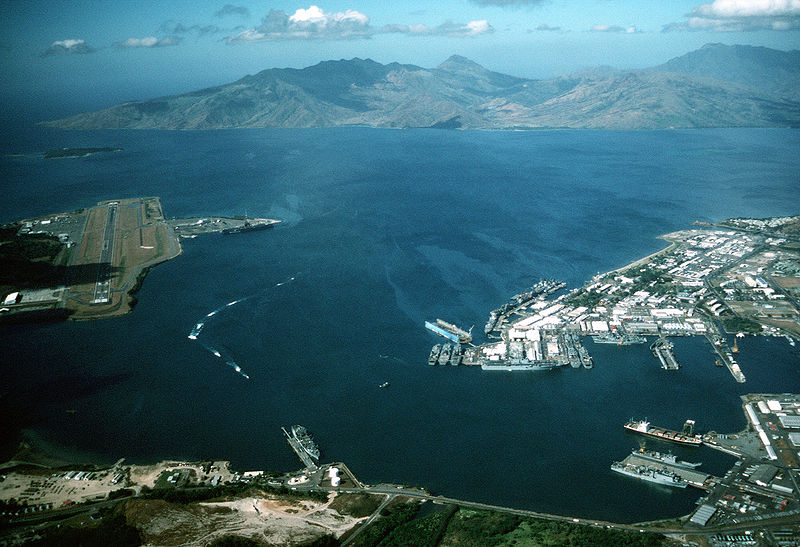
English: Aerial view of the U.S. Navy Naval Station Subic Bay, Philippines, circa in 1990, with Naval Air Station Cubi Point visible on the left.
This photo was most probably taken in January of 1991, during the build-up to Operations DESERT SHIELD & DESERT STORM, but before the 12 June 1991 eruption of Mt. Pinatubo. In addition to the USS Ranger, moored at Leyte Pier, a Tarawa-class LHA is visible in the image, tied up in the maintenance area of the Subic Bay Naval Shipyard. The only Tarawa-class ship in the WestPac at the time was the Tarawa. The other west coast LHAs were both in port undergoing overhaul/maintenance in California (Belleau Wood (LHA 3) in San Diego and Peleliu (LHA 5) in Long Beach. Also visible at Alava Pier, above the Tarawa, is an Iwo Jima-class LPH, and at least seven other amphibious ships (LPD, LSD, LST). This is consistent with two full Amphibious Readiness Groups (ARGs) deployed for Operation DESERT SHIELD/DESERT STORM.Note: The photo is dated, incorrectly, as "1 January 1990". The aircraft carrier USS Ranger (CV 61) is docked at NAS Cubi Point. Ranger was deployed to the Western Pacific from 24 February to 24 August 1989 and to the Western Pacific and the Indian Ocean during the 1991 Gulf War from 8 December 1990 to 8 June 1991. |
|||
| 日期 | 約1990年 | |||
| 來源 |
|
|||
| 作者 | PH1(Nac) David R. Sanner, U.S. Navy |
| 拍攝地點 | | 位於此地的本圖片與其他圖片: OpenStreetMap |
|---|
授權條款
 | ||
| 此作品無已知的著作權限制,亦不受所有相關和鄰接的權利限制。 | ||
檔案歷史
點選日期/時間以檢視該時間的檔案版本。
| 日期/時間 | 縮圖 | 尺寸 | 用戶 | 備註 | |
|---|---|---|---|---|---|
| 目前 | 2007年4月25日 (三) 01:27 | | 2,780 × 1,900(3.45 MB) | Dual Freq | {{Information |Description= |Source=[http://www.dodmedia.osd.mil/Assets/Still/1991/Navy/DN-ST-91-11630.JPEG ID:DN-ST-91-11630] |Author=Camera Operator: PH1(NAC) DAVID R. SANNER </br>Service Depicted: Navy An aerial view of the station and, to the left, N |
檔案用途
全域檔案使用狀況
以下其他 wiki 使用了這個檔案:
- arz.wikipedia.org 的使用狀況
- ca.wikipedia.org 的使用狀況
- ceb.wikipedia.org 的使用狀況
- en.wikipedia.org 的使用狀況
- fr.wikipedia.org 的使用狀況
- fr.wikivoyage.org 的使用狀況
- it.wikipedia.org 的使用狀況
- ja.wikipedia.org 的使用狀況
- nl.wikipedia.org 的使用狀況
- pl.wikipedia.org 的使用狀況
- pt.wikipedia.org 的使用狀況
- sv.wikipedia.org 的使用狀況
- uk.wikipedia.org 的使用狀況
- vi.wikipedia.org 的使用狀況
- www.wikidata.org 的使用狀況