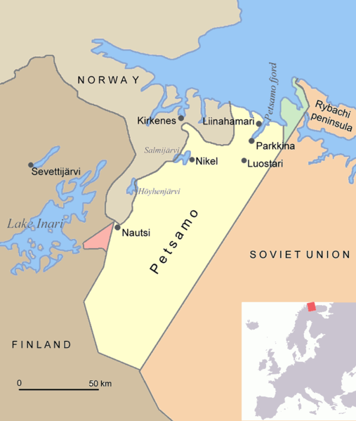
File:Petsamo.png

預覽大小:507 × 599 像素。 其他解析度:203 × 240 像素 | 406 × 480 像素。
原始檔案 (800 × 945 像素,檔案大小:30 KB,MIME 類型:image/png)
檔案歷史
點選日期/時間以檢視該時間的檔案版本。
| 日期/時間 | 縮圖 | 尺寸 | 用戶 | 備註 | |
|---|---|---|---|---|---|
| 目前 | 2015年6月17日 (三) 19:08 |  | 800 × 945(30 KB) | Hohum | Clearer |
| 2005年8月1日 (一) 17:48 |  | 800 × 945(70 KB) | Jniemenmaa | Map of Petsamo area in northern Finland/Soviet Union/Russia. The green area is the Finnish part of the Rybachi peninsula which was ceded to the Soviet Union after the Winter War. The Red area is the Jäniskoksi area ceded to the SU some years after the C |
檔案用途
全域檔案使用狀況
以下其他 wiki 使用了這個檔案:
- ar.wikipedia.org 的使用狀況
- ba.wikipedia.org 的使用狀況
- ca.wikipedia.org 的使用狀況
- cs.wikipedia.org 的使用狀況
- da.wikipedia.org 的使用狀況
- de.wikipedia.org 的使用狀況
- en.wikipedia.org 的使用狀況
- Central European Time
- User:Jniemenmaa/images
- Rybachy Peninsula
- Walter Schuck
- Heinrich Bartels
- Pechengsky District
- Jakob Norz
- Operation EF (1941)
- Norway–Russia border
- Rudi Linz
- August Mors
- Jäniskoski-Niskakoski territory
- User:Falcaorib/Russia and Soviet Union
- User:Falcaorib/Sweden and Finland
- Friedrich-Wilhelm Strakeljahn
- eo.wikipedia.org 的使用狀況
- es.wikipedia.org 的使用狀況
- eu.wikipedia.org 的使用狀況
- fi.wikipedia.org 的使用狀況
- fr.wikipedia.org 的使用狀況
- gl.wikipedia.org 的使用狀況
- hu.wikipedia.org 的使用狀況
- it.wikipedia.org 的使用狀況
- nl.wikipedia.org 的使用狀況
檢視此檔案的更多全域使用狀況。


