File:Scarborough Shoal Landsat.jpg

預覽大小:800 × 518 像素。 其他解析度:320 × 207 像素 | 640 × 415 像素 | 1,000 × 648 像素。
原始檔案 (1,000 × 648 像素,檔案大小:97 KB,MIME 類型:image/jpeg)
摘要
| 描述 |
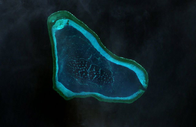
Deutsch: Landsat-7-Bild des Scarborough-Riffs im Westphilippinischen Meer
|
| 日期 | |
| 來源 | http://www.oceandots.com/pacific/scarborough/scarborough2.php |
| 作者 | NASA |
| 這是一張修飾過的圖片,即本圖片是用軟體修改過後的版本,修改的方式或內容有:color adjusted。
|
授權條款
| 本作品由NASA創作,屬於公有領域。根據NASA的版權政策:“NASA的創作除非另有聲明否則不受版權保護。”(參見:Template:PD-USGov/zh,NASA版權政策或JPL圖像使用政策) | ||
 |
警告:
|
檔案歷史
點選日期/時間以檢視該時間的檔案版本。
| 日期/時間 | 縮圖 | 尺寸 | 用戶 | 備註 | |
|---|---|---|---|---|---|
| 目前 | 2010年2月22日 (一) 14:41 | | 1,000 × 648(97 KB) | Telim tor | == {{int:filedesc}} == {{Information |Description= {{de|Landsat-7-Bild des Scarborough-Riffs im Südchinesischen Meer}} {{en|Landsat 7 image of Scarborough Shoal in the South China Sea}} |Source=http://www.oceandots.com/pacific/scarborough/scarborough2.ph |
檔案用途
全域檔案使用狀況
以下其他 wiki 使用了這個檔案:
- ca.wikipedia.org 的使用狀況
- cs.wikipedia.org 的使用狀況
- de.wikipedia.org 的使用狀況
- en.wikipedia.org 的使用狀況
- es.wikipedia.org 的使用狀況
- fa.wikipedia.org 的使用狀況
- fi.wikipedia.org 的使用狀況
- fr.wikipedia.org 的使用狀況
- it.wikipedia.org 的使用狀況
- ja.wikipedia.org 的使用狀況
- ko.wikipedia.org 的使用狀況
- mk.wikipedia.org 的使用狀況
- sv.wikipedia.org 的使用狀況
- tl.wikipedia.org 的使用狀況
- tr.wikipedia.org 的使用狀況
- vi.wikipedia.org 的使用狀況
- www.wikidata.org 的使用狀況
- zh-yue.wikipedia.org 的使用狀況