File:Stonehenge World Heritage Site map 2.svg

此 SVG 檔案的 PNG 預覽的大小:497 × 600 像素。 其他解析度:199 × 240 像素 | 398 × 480 像素 | 636 × 768 像素 | 848 × 1,024 像素 | 1,696 × 2,048 像素 | 1,438 × 1,736 像素。
原始檔案 (SVG 檔案,表面大小:1,438 × 1,736 像素,檔案大小:1.57 MB)
摘要
| 描述 |
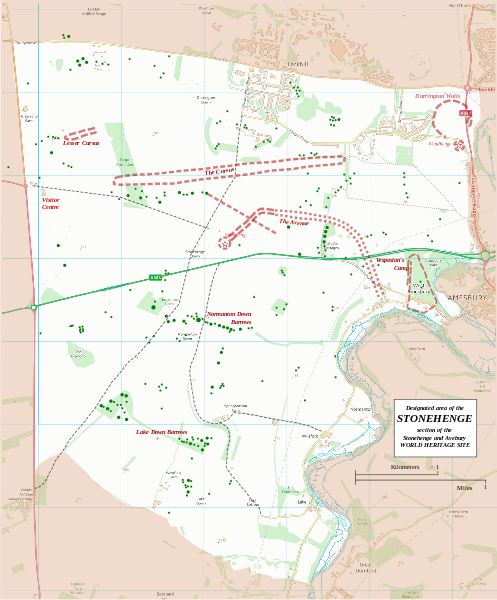
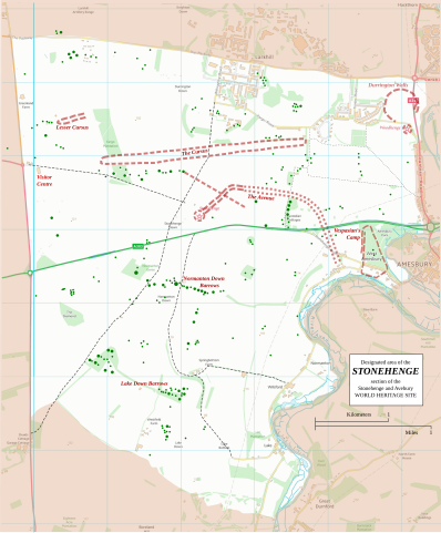
English: Boundary and key sites on the Avebury section of the Stonehenge, Avebury and Associated Sites World Heritage Site |
| 日期 | |
| 來源 | OS Open Data with additional material cited at World Heritage Site list No 373 |
| 作者 | RobinLeicester building on OS OpenData VextorMap District Raster files |
| 拍攝地點 | | 位於此地的本圖片與其他圖片: OpenStreetMap |
|---|
Principal monuments and earthworks are shown in Red. Barrows are indicated by green dots.
授權條款
This file is licensed by the Ordnance Survey of the United Kingdom under their OS OpenData License
In short: you are free to distribute and modify the file as long as you attribute (including year), the Ordnance Survey. 姓名標示: Contains Ordnance Survey data © Crown copyright and database right (year) Note: Derivative works can be licensed under any Creative Commons Attribution 3.0 Licence. |
_(St_Edwards_Crown).svg)
|
This file is licensed under the United Kingdom Open Government Licence v3.0. |
See also: Meta for information on usage on Wikimedia wikis.
|
檔案歷史
點選日期/時間以檢視該時間的檔案版本。
| 日期/時間 | 縮圖 | 尺寸 | 用戶 | 備註 | |
|---|---|---|---|---|---|
| 目前 | 2015年1月13日 (二) 22:36 | | 1,438 × 1,736(1.57 MB) | RobinLeicester | User created page with UploadWizard |
檔案用途
下列頁面有用到此檔案:
全域檔案使用狀況
以下其他 wiki 使用了這個檔案:
- cs.wikipedia.org 的使用狀況
- de.wikipedia.org 的使用狀況
- en.wikipedia.org 的使用狀況
- fi.wikipedia.org 的使用狀況
- fr.wikipedia.org 的使用狀況
- fr.wikivoyage.org 的使用狀況
- ja.wikipedia.org 的使用狀況
- kw.wikipedia.org 的使用狀況
- nl.wikipedia.org 的使用狀況
- ru.wikipedia.org 的使用狀況
- simple.wikipedia.org 的使用狀況
- sl.wikipedia.org 的使用狀況
- ur.wikipedia.org 的使用狀況