File:America noviter delineata.jpg
預覽大小:790 × 600 像素。 其他解析度:316 × 240 像素 | 632 × 480 像素 | 1,012 × 768 像素 | 1,280 × 972 像素 | 2,560 × 1,943 像素 | 5,965 × 4,528 像素。
原始檔案 (5,965 × 4,528 像素,檔案大小:5.17 MB,MIME 類型:image/jpeg)
摘要
| 描寫 |
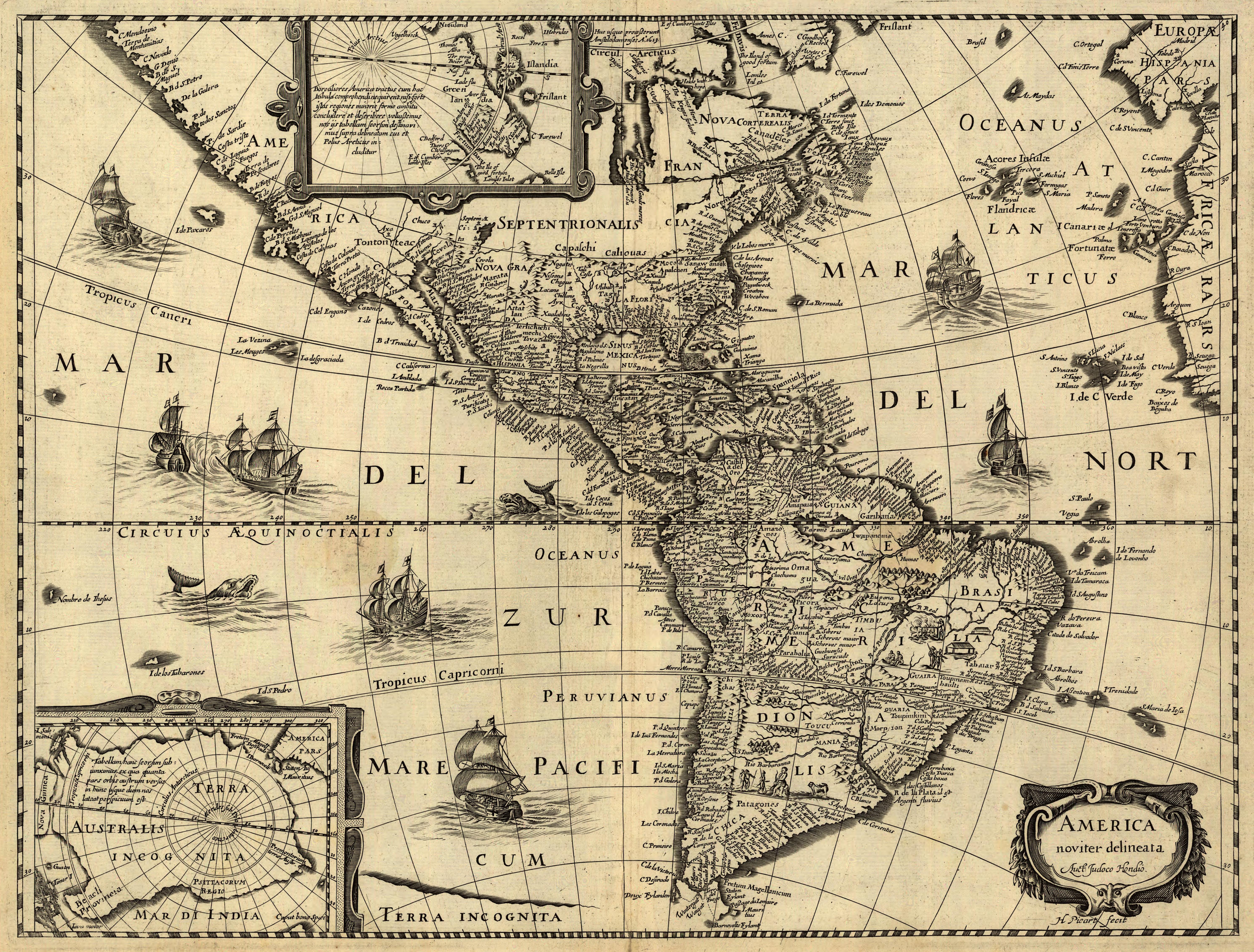
Latina: America noviter delineata / auct. Jodoco Hondio; H. Picard fecit.
English: America newly delineated / by Jodocus Hondius; engraved by H. Picard. A 17th-century map of the Americas. Scale ca. 1:45,000,000. Map ranges from W 125°–W 5° and N 70°–S 60°. Also includes insets of the polar regions.
Français : L'amérique nouvellement cartographiée / Par Jocodus Hondius; gravé par H. Picard. Une carte des amériques du XVIIe siècle. Echelle: environ 1:45 000 000. La carte couvre un espace allant de 5°W à 125°W et de 60°S à 70°N. Elle inclut aussi en encarts les régions polaires. |
|||||
| 來源 |
Published by Jean Boisseau. The U.S. Library of Congress gives the date of publication as "1640?", while another source suggests a first publication of 1637 or 1639. Digital version produced by the U.S. Library of Congress Geography and Map Division. JPEG 2000 source image converted to JPEG by User:Delirium using JasPer 1.701.0, since JPEG 2000 is not as of this uploading supported on Commons.
|
|||||
| 創作作者 |
Jodocus Hondius (1563-1612) |
|||||
| 授權許可 (重用此檔案) |
|
|||||
| 地理參考 | 如果不合適,請設定「warp_status = skip」為隱藏。 | |||||

Awards
|

This image was selected as picture of the day on Wikimedia Commons for 17 April 2007. It was captioned as follows: Other languages:
Español: America noviter delineata, un mapa de América del siglo XVII realizado por Jodocus Hondius. Esperanto: America noviter delineata, mapo de Ameriko desegnita en la 17-a jarcento de Jodocus Hondius. Français : America noviter delineata, une carte du XVIIe siècle des Amériques, dressée par Jodocus Hondius Italiano: America noviter delineata, una mappa delle Americhe realizzata nel XVII secolo da Jodocus Hondius. Magyar: America noviter delineata, 17. századi térkép Amerikáról, Jodocus Hondiusalkotása Nederlands: America noviter delineata, kaart uit de 17e eeuw van het continent Amerika door de cartograaf Jodocus Hondius Polski: America noviter delineata, siedemnastowieczna mapa Ameryki autorstwa Jodocusa Hondiusa (1563-1611) Suomi: America noviter delineata, Jodocus Hondiuksen tekemä Amerikankartta 1600-luvulta Svenska: America noviter delineata är en karta över Amerika ritad på 1600-talet av den flamländske kartografen Jodocus Hondius. 日本語: America noviter delineata、Jodocus Hondiusによる17世紀のアメリカの地図。 中文(繁體): 17世紀時由約道庫斯·洪地烏斯繪製的《最新美洲地圖》 |
檔案歷史
點選日期/時間以檢視該時間的檔案版本。
| 日期/時間 | 縮圖 | 尺寸 | 用戶 | 備註 | |
|---|---|---|---|---|---|
| 目前 | 2006年6月14日 (三) 06:33 | | 5,965 × 4,528(5.17 MB) | Delirium | ''America noviter delineata / auct. Jodoco Hondio; H. Picard fecit.'' (America newly delineated / by Jodoco Hondia; engraved by H. Picard.) A 17th-century map of the Americas. Scale ca. 1:45,000,000. Map ranges from W 125°–W 5° and N 70&d |
檔案用途
下列89個頁面有用到此檔案:
- P·J·帕特森
- 乔治·马克斯韦尔·理查兹
- 亞歷杭德羅·托萊多
- 何塞·埃瓦里斯托·乌里武鲁
- 何塞·普拉西多·卡马尼奥
- 何塞·菲格罗亚·阿尔科塔
- 何塞·费利克斯·乌里武鲁
- 何塞·马里亚·贝拉斯科·伊瓦拉
- 佩德罗·何塞·塞瓦略斯
- 儒利奥·普列斯特斯
- 加布里埃尔·加西亚·莫雷诺
- 华盛顿·路易斯·佩雷拉·德索萨
- 博尼法斯·亚历山大
- 卡思伯特·塞巴斯蒂安
- 卡洛斯·佩列格里尼
- 卡洛斯·梅萨
- 卡洛斯·罗伯托·弗洛雷斯
- 卡洛斯·罗伯托·雷纳
- 卡洛斯·阿尔韦托·阿罗约·德尔里奥
- 危地马拉副总统
- 吉列爾莫·羅德里格斯·拉臘
- 坎波斯·萨莱斯
- 埃廷·伊斯
- 埃洛伊·阿尔法罗
- 埃皮塔西奧·佩索阿
- 埃米莉·德容-埃赫
- 奥雷利奥·莫斯克拉
- 安东尼奥·弗洛雷斯·希洪
- 安德烈斯·德尔瓦列
- 安東尼·卡莫納
- 尼卡诺尔·杜阿尔特·弗鲁托斯
- 尼古拉斯·阿韦利亚内达
- 尼洛·佩萨尼亚
- 巴斯德奥·潘戴
- 布鲁斯·戈尔丁
- 帕特里克·曼宁
- 弗朗西斯科·哈维尔·德卢纳·皮萨罗
- 弗里茨·胡德赫德拉赫
- 弗雷德里克·巴兰坦
- 德尔芬·莫雷拉
- 拉尔夫·冈萨维斯
- 拉斐尔·莱昂纳多·卡列哈斯
- 拉斐尔·阿迭戈·布鲁诺
- 普鲁登特·德·莫拉伊斯
- 曼努埃尔·戈麦斯·佩德拉萨
- 比森特·拉蒙·罗卡
- 比森特·罗卡富埃特
- 海梅·罗尔多斯·阿吉莱拉
- 爱德华多·罗德里格斯
- 皮尔莱特·路易茜
- 米格尔·华雷斯·塞尔曼
- 米歇尔·皮埃尔-路易
- 约多库斯·洪第乌斯
- 维多利诺·德拉普拉萨
- 罗克·萨恩斯·培尼亚
- 罗纳德·韦内蒂安
- 美洲
- 耶乌德·西蒙·穆纳罗
- 聖地亞哥·藤森
- 肖恩·理查德斯
- 肯尼·安东尼
- 肯尼思·霍尔
- 胡利奥·玛丽亚·桑吉内蒂
- 胡安·何塞·弗洛雷斯
- 若泽·里尼亚雷斯
- 莱昂尼达斯·普拉萨
- 菲利西亞諾·比埃拉
- 萨姆·海因兹
- 蘇珊娜·樋口
- 詹姆斯·卡莱尔
- 詹姆斯·舍伊佛爾·伍茲沃思
- 让-雅克·德萨林
- 豪尔赫·巴特列
- 豪尔赫·德尔卡斯蒂略·加尔维斯
- 賈斯頓·布朗
- 贡萨洛·科尔多瓦
- 赵朴 (外交官)
- 路易斯·萨恩斯·培尼亚
- 里卡多·马杜罗
- 阿图尔·贝纳德斯
- 阿方索·洛佩斯·普马雷霍
- 阿爾弗雷多·波韋達
- 雅克-爱德华·亚历克西
- 馬丁·托里霍斯
- 马克·尤德尔
- 鲍德温·斯潘塞
- Wikipedia:每日图片/2007年4月
- Wikipedia:每日图片/2007年4月17日
- Template:America-poli-bio-stub
全域檔案使用狀況
以下其他 wiki 使用了這個檔案:
- af.wikipedia.org 的使用狀況
- ar.wikipedia.org 的使用狀況
- ba.wikipedia.org 的使用狀況
- bcl.wikipedia.org 的使用狀況
- bn.wikipedia.org 的使用狀況
- ca.wikipedia.org 的使用狀況
- en.wikipedia.org 的使用狀況
- Spanish colonization of the Americas
- History of Latin America
- Portal:Latin America
- Portal talk:Latin America
- Talk:History of Latin America/Sandbox
- Portal:Latin America/Featured picture list
- Portal:Latin America/Featured picture/1
- History of navigation
- Talk:History of South America/sandbox
- Historiography of Colonial Spanish America
- Cartography of Latin America
- Economic history of Latin America
- eo.wikipedia.org 的使用狀況
- es.wikipedia.org 的使用狀況
- es.wikiversity.org 的使用狀況
- eu.wikipedia.org 的使用狀況
- fa.wikipedia.org 的使用狀況
- fr.wikipedia.org 的使用狀況
- gl.wikipedia.org 的使用狀況
- he.wikipedia.org 的使用狀況
檢視此檔案的更多全域使用狀況。