File:Archipel de Brehat.jpg

預覽大小:800 × 509 像素。 其他解析度:320 × 203 像素 | 640 × 407 像素 | 1,178 × 749 像素。
原始檔案 (1,178 × 749 像素,檔案大小:161 KB,MIME 類型:image/jpeg)
| 描述 |
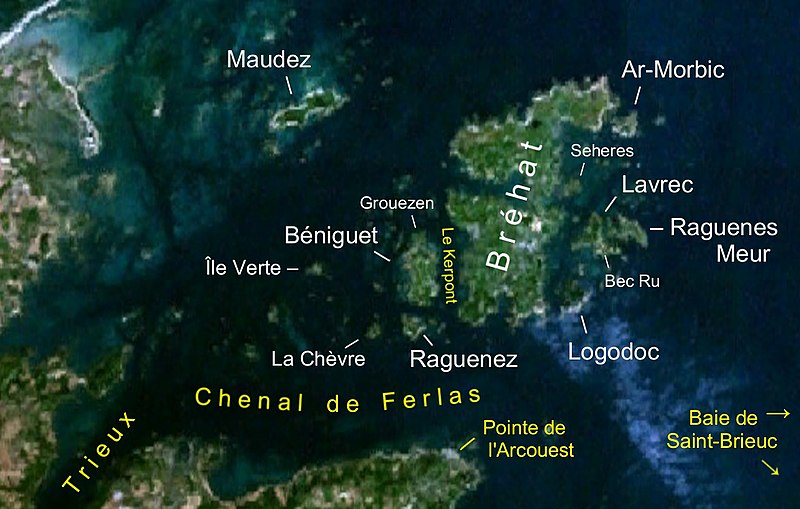
Deutsch: Satellitenbild der Inselgruppe Bréhat. Die Namen der Inseln sind weißgeschrieben, andere Angaben gelb.
Français : Image de satellite de l'archipel de Bréhat |
| 日期 | screenshot from World Wind on 26 May 2007 |
| 來源 | NASA World Wind (see below); edited using the Gimp |
| 作者 | NASA; editing by User:Ibn Battuta |
| 本圖像屬於公有領域,因其為NASA的World Wind衛星地圖瀏覽器的一張截圖,且使用了公有領域圖層,如Blue Marble、MODIS、Landsat、SRTM、USGS、GLOBE等。
|
 |
檔案歷史
點選日期/時間以檢視該時間的檔案版本。
| 日期/時間 | 縮圖 | 尺寸 | 用戶 | 備註 | |
|---|---|---|---|---|---|
| 目前 | 2007年5月26日 (六) 21:43 | | 1,178 × 749(161 KB) | Ibn Battuta | {{Information |Description={{de|Satellitenbild der Inselgruppe Bréhat. Die Namen der Inseln sind weißgeschrieben andere Angaben gelb.}} {{fr|Image de satellite de l'archipel de Bréhat}} |Source=NA |
檔案用途
下列頁面有用到此檔案:
全域檔案使用狀況
以下其他 wiki 使用了這個檔案:
- br.wikipedia.org 的使用狀況
- ca.wikipedia.org 的使用狀況
- cy.wikipedia.org 的使用狀況
- de.wikipedia.org 的使用狀況
- eo.wikipedia.org 的使用狀況
- eu.wikipedia.org 的使用狀況
- fr.wikipedia.org 的使用狀況
- www.wikidata.org 的使用狀況