File:Chesapeake and Ohio Canal National Historical Park (map).jpg

預覽大小:226 × 598 像素。 其他解析度:90 × 240 像素 | 181 × 480 像素 | 290 × 768 像素 | 387 × 1,024 像素 | 774 × 2,048 像素 | 2,740 × 7,248 像素。
原始檔案 (2,740 × 7,248 像素,檔案大小:6.8 MB,MIME 類型:image/jpeg)
.jpg?uselang=zh-mo)
.jpg?uselang=zh-mo)
.jpg?action=history&uselang=zh-mo)
.jpg)
摘要

|
File:Chesapeake and Ohio Canal National Historical Park (map).svg是本檔案的向量版本。 如果品質不低,就應該優先使用該檔案,而非JPG檔案。
File:Chesapeake and Ohio Canal National Historical Park (map).jpg → File:Chesapeake and Ohio Canal National Historical Park (map).svg
更多資訊請參閱Help:SVG/zh。 |
.svg) |
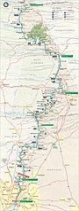
| 描述 | Map of the Chesapeake and Ohio Canal National Historical Park — along the former Chesapeake and Ohio Canal between Cumberland, Maryland, and Washington, D.C., USA. |
| 日期 | |
| 來源 | United States National Park Service, website for Chesapeake and Ohio Canal National Historical Park (http://www.nps.gov/choh/planyourvisit/parkmaps.htm). |
| 作者 | National Park Service, US Department of the Interior. |
| 授權許可 (重用此檔案) |
Public domain - original work of the US Federal Government. |
授權條款
| This image or media file contains material based on a work of a National Park Service employee, created as part of that person's official duties. As a work of the U.S. federal government, such work is in the public domain in the United States. See the NPS website and NPS copyright policy for more information. |
檔案歷史
點選日期/時間以檢視該時間的檔案版本。
| 日期/時間 | 縮圖 | 尺寸 | 用戶 | 備註 | |
|---|---|---|---|---|---|
| 目前 | 2007年2月6日 (二) 15:38 | 2,740 × 7,248(6.8 MB) | Daderot | {{Information |Description=Map of the Chesapeake and Ohio Canal National Historical Park, along the former Chesapeake and Ohio Canal between Cumberland, Maryland, and Washington, D.C., USA. |Source=United States National Park Service, website for Chesapea |
檔案用途
下列頁面有用到此檔案:
全域檔案使用狀況
以下其他 wiki 使用了這個檔案:
- da.wikipedia.org 的使用狀況
- de.wikipedia.org 的使用狀況
- en.wikipedia.org 的使用狀況
- fr.wikipedia.org 的使用狀況
- no.wikipedia.org 的使用狀況
- pl.wikipedia.org 的使用狀況
.jpg)