File:ElectoralCollege1824-Large.png
預覽大小:800 × 585 像素。 其他解析度:320 × 234 像素 | 640 × 468 像素 | 868 × 635 像素。
原始檔案 (868 × 635 像素,檔案大小:115 KB,MIME 類型:image/png)
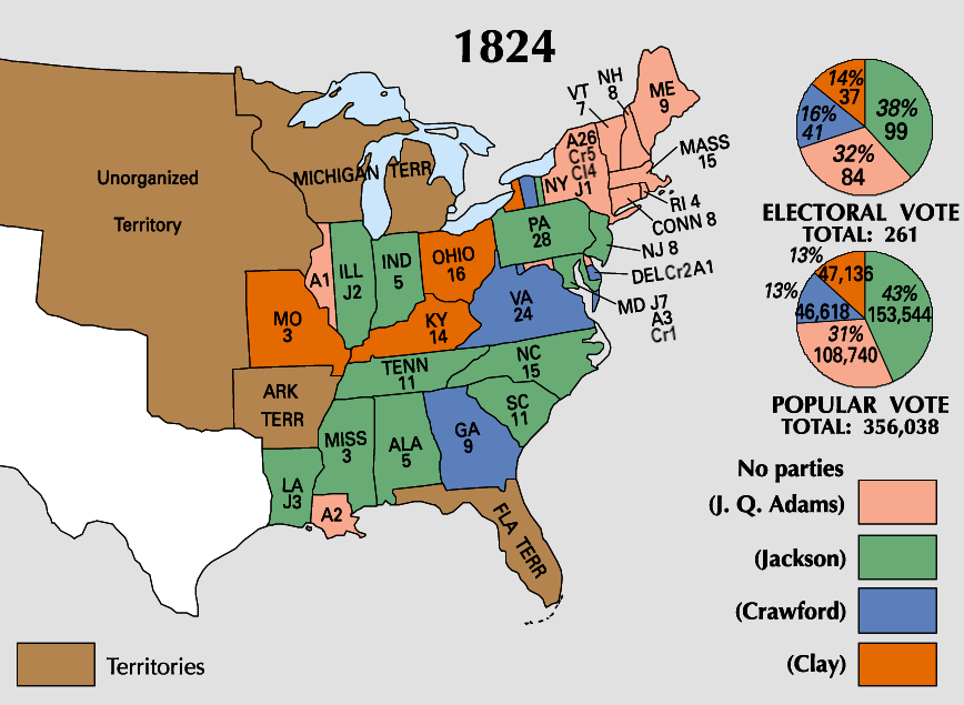
| U.S. presidential election maps from the National Atlas of the United States |
| See also: SVG maps |
| 1789 · 1792 · 1796 · 1800 · 1804 · 1808 · 1812 · 1816 · 1820 · 1824 · 1828 · 1832 · 1836 · 1840 · 1844 · 1848 · 1852 · 1856 · 1860 · 1864 · 1868 · 1872 · 1876 · 1880 · 1884 · 1888 · 1892 · 1896 · 1900 · 1904 · 1908 · 1912 · 1916 · 1920 · 1924 · 1928 · 1932 · 1936 · 1940 · 1944 · 1948 · 1952 · 1956 · 1960 · 1964 · 1968 · 1972 · 1976 · 1980 · 1984 · 1988 · 1992 · 1996 · 2000 · 2004 |
摘要
授權條款
本地圖取自美國國家地圖集的某個版本。國家地圖集的絕大多數作品是美國聯邦政府的作品,因此屬於公有領域。
連結網址︰ NationalAtlas.gov | 1970年印刷版︰ 國會檔案館, Perry-Castañeda圖書館
|
檔案歷史
點選日期/時間以檢視該時間的檔案版本。
| 日期/時間 | 縮圖 | 尺寸 | 用戶 | 備註 | |
|---|---|---|---|---|---|
| 目前 | 2023年6月19日 (一) 20:57 | | 868 × 635(115 KB) | Rogl94 | Corrected Clay number in New York from 14 to 4, distinguished more between Crawford and Clay |
| 2006年1月22日 (日) 18:01 |  | 868 × 635(83 KB) | Red devil 666 | {{PD-USGov-Atlas}} |
檔案用途
下列頁面有用到此檔案:
全域檔案使用狀況
以下其他 wiki 使用了這個檔案:
- en.wikipedia.org 的使用狀況
- ja.wikipedia.org 的使用狀況
- nl.wikipedia.org 的使用狀況
- no.wikipedia.org 的使用狀況
- ru.wikipedia.org 的使用狀況
- sv.wikipedia.org 的使用狀況
- tr.wikipedia.org 的使用狀況
- uk.wikipedia.org 的使用狀況
- vi.wikipedia.org 的使用狀況
- www.wikidata.org 的使用狀況