File:Enceladus PIA06191.jpg

原始檔案 (3,750 × 2,876 像素,檔案大小:1.05 MB,MIME 類型:image/jpeg)
摘要
| 描述 |
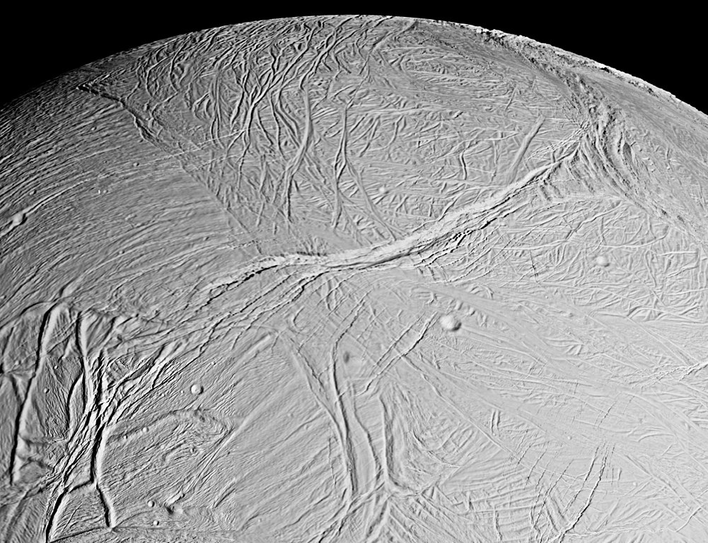
English: This spectacular view is a mosaic of four high resolution images taken by the Cassini spacecraft narrow angle camera on Feb. 16, 2005, during its close flyby of Saturn's moon Enceladus.
The view is about 300 kilometers (200 miles) across and shows the myriad of faults, fractures, folds, troughs and craters that make this Saturnian satellite especially intriguing to planetary scientists. More than 20 years ago, NASA's Voyager spacecraft gave hints of a surface cut by tectonic features, and subsequent images of other icy moons have revealed many different ways that stresses have acted on icy moon crusts. The new close-up images of Enceladus, which has a diameter of 505 kilometers (314 miles), show some familiar-looking features and others that are brand new. The work required to unravel their origins, their formation sequence, and the implications for the evolution of icy solar system bodies is just beginning. Voyager images of Enceladus, which were obtained at much poorer spatial resolution, showed terrains like those seen here. They were called "smooth plains" because they appeared to exhibit little topographic relief. However, Cassini has now viewed these terrains at almost 10 times better resolution. The new images reveal very complex systems of fractures, resurfaced terrain, and in some cases, topographic relief greater than several hundred meters. Many styles of fracturing are evident in this mosaic. Extending downward from the top center of the mosaic for hundreds of kilometers is a broad belt of complex, interwoven fractures. A huge rift 5 kilometers (3 miles)-wide dissects this belt and extends into several older-looking, distinct regions or "cells" of terrain that themselves exhibit distinct fracture patterns. Because Cassini flew rapidly past Enceladus, the right-side images were taken from a slightly different perspective than the left, and are delineated by the white box. The mosaic covers longitudes from about 254 west to 296 west and latitudes from 60 south to the equator. The images were taken in visible light on Feb. 17, 2005, at distances ranging from of 26,140 to 17,434 kilometers (16,243 to 10,833 miles) from Enceladus and at Sun-Enceladus-spacecraft, or phase, angles ranging from 27 to 29 degrees. Pixel scale in the left-side image is 150 meters (492 feet) per pixel; in the right-side (white box) image, scale is 105 meters (344 feet) per pixel. The image has been contrast-enhanced to aid visibility. |
| 日期 | |
| 來源 | http://photojournal.jpl.nasa.gov/catalog/PIA06191 |
| 作者 | NASA/JPL/Space Science Institute |
| 此標籤不表示文件的著作權狀態。任何文件在附有此標籤的同時還需要一個有效的著作權標籤。請參閱許可協議說明頁面以了解更多資訊。 其他語言:
|
授權條款
| 本作品由NASA創作,屬於公有領域。根據NASA的版權政策:“NASA的創作除非另有聲明否則不受版權保護。”(參見:Template:PD-USGov/zh,NASA版權政策或JPL圖像使用政策) | ||
 |
警告:
|
檔案歷史
點選日期/時間以檢視該時間的檔案版本。
| 日期/時間 | 縮圖 | 尺寸 | 用戶 | 備註 | |
|---|---|---|---|---|---|
| 目前 | 2016年4月1日 (五) 22:54 | | 3,750 × 2,876(1.05 MB) | Banjo | better res |
| 2005年2月20日 (日) 15:50 |  | 2,340 × 1,580(623 KB) | Bricktop | Enceladus image from NASA |
檔案用途
下列頁面有用到此檔案:
全域檔案使用狀況
以下其他 wiki 使用了這個檔案:
- ar.wikipedia.org 的使用狀況
- cs.wikipedia.org 的使用狀況
- da.wikipedia.org 的使用狀況
- de.wikipedia.org 的使用狀況
- en.wikipedia.org 的使用狀況
- en.wikinews.org 的使用狀況
- et.wikipedia.org 的使用狀況
- eu.wikipedia.org 的使用狀況
- gl.wikipedia.org 的使用狀況
- he.wikipedia.org 的使用狀況
- io.wikipedia.org 的使用狀況
- it.wikipedia.org 的使用狀況
- ja.wikipedia.org 的使用狀況
- lb.wikipedia.org 的使用狀況
- nl.wikipedia.org 的使用狀況
- pl.wikipedia.org 的使用狀況
- ro.wikipedia.org 的使用狀況
- ru.wikipedia.org 的使用狀況
- srn.wikipedia.org 的使用狀況
- sv.wikinews.org 的使用狀況
- uk.wikipedia.org 的使用狀況
- uz.wikipedia.org 的使用狀況
- www.wikidata.org 的使用狀況