File:Hurricane Emily 16 july 2005 1545Z.jpg

預覽大小:466 × 599 像素。 其他解析度:187 × 240 像素 | 373 × 480 像素 | 597 × 768 像素 | 796 × 1,024 像素 | 1,593 × 2,048 像素 | 5,600 × 7,200 像素。
原始檔案 (5,600 × 7,200 像素,檔案大小:6.25 MB,MIME 類型:image/jpeg)
摘要
| 描述 |
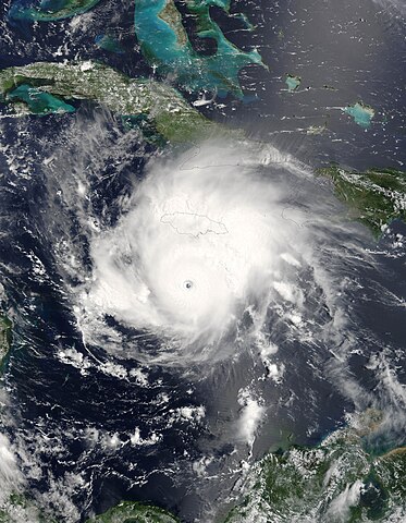
Hurricane Emily was spinning through the Caribbean south of Jamacia on July 16, 2005, when the Moderate Resolution Imaging Spectroradiometer (MODIS) on the Terra satellite captured this image at 15:45 UTC (11:45 a.m. Eastern Daylight Time). At this time, Emily was a well-developed hurricane with winds over 230 kilometers an hour (125 knots) and gusts as high as 285 km/hr (155 knots). As shown in this satellite image, the storm is passing roughly east to west well south of Jamaica (around 160 kilometers, or 100 miles), but the heavy rains in the storm's outer bands fell on an already sodden island still recovering from Hurricane Dennis, which similarly glanced the island on July 7. Emily's rains caused flooding, which has resulted in four deaths on the island. Tourists in the Yucatan Peninsula are being evacuated from resort areas and beaches as the hurricane continues on track to make landfall there during the morning of July 18, 2005. |
|||||
| 日期 | ||||||
| 來源 | http://earthobservatory.nasa.gov/NaturalHazards/natural_hazards_v2.php3?img_id=12967 | |||||
| 作者 | NASA image provided courtesy of Jeff Schmaltz, MODIS Rapid Response team. | |||||
| 授權許可 (重用此檔案) |
|
|||||
| 其他版本 | Image:Hurricane Emily.jpg |

檔案歷史
點選日期/時間以檢視該時間的檔案版本。
| 日期/時間 | 縮圖 | 尺寸 | 用戶 | 備註 | |
|---|---|---|---|---|---|
| 目前 | 2023年7月31日 (一) 09:44 | | 5,600 × 7,200(6.25 MB) | Nino Marakot | Reverted to version as of 06:40, 23 July 2018 (UTC) |
| 2018年12月6日 (四) 22:56 |  | 6,401 × 8,401(9.55 MB) | FleurDeOdile | actual center | |
| 2018年7月23日 (一) 06:40 |  | 5,600 × 7,200(6.25 MB) | Nino Marakot | Reverted to version as of 21:47, 2 November 2006 (UTC) | |
| 2018年4月22日 (日) 15:43 |  | 1,540 × 1,900(676 KB) | CooperScience | Larger file, centered, better quality | |
| 2017年5月24日 (三) 09:04 |  | 466 × 599(84 KB) | A1Cafel | clearer | |
| 2006年11月2日 (四) 21:47 |  | 5,600 × 7,200(6.25 MB) | Good kitty | == Summary == {{Information |Description=Hurricane Emily was spinning through the Caribbean south of Jamacia on July 16, 2005, when the Moderate Resolution Imaging Spectroradiometer (MODIS) on the Terra satellite captured this image at 15:45 UTC (11:45 a. |
檔案用途
下列7個頁面有用到此檔案:
全域檔案使用狀況
以下其他 wiki 使用了這個檔案:
- ca.wikipedia.org 的使用狀況
- de.wikipedia.org 的使用狀況
- en.wikipedia.org 的使用狀況
- eo.wikipedia.org 的使用狀況
- es.wikipedia.org 的使用狀況
- eu.wikipedia.org 的使用狀況
- fi.wikipedia.org 的使用狀況
- fr.wikipedia.org 的使用狀況
- hu.wikipedia.org 的使用狀況
- it.wikipedia.org 的使用狀況
- pl.wikipedia.org 的使用狀況
- pt.wikipedia.org 的使用狀況
- ru.wikipedia.org 的使用狀況
- simple.wikipedia.org 的使用狀況
- sv.wikipedia.org 的使用狀況
- uk.wikipedia.org 的使用狀況
- vi.wikipedia.org 的使用狀況
- www.wikidata.org 的使用狀況