File:Kalmykia03.png

預覽大小:680 × 600 像素。 其他解析度:272 × 240 像素 | 544 × 480 像素 | 738 × 651 像素。
原始檔案 (738 × 651 像素,檔案大小:44 KB,MIME 類型:image/png)
摘要
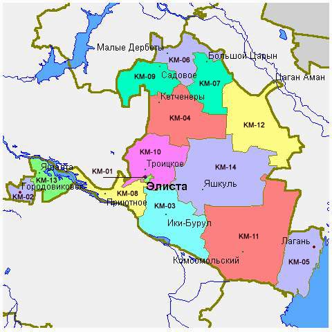
- Map of the Republic of Kalmykia.
Source and license

|
This map has been uploaded by Electionworld from en.wikipedia.org to enable the |
Map made by PANONIAN
| 此作品已由其作者,PANONIAN,釋出至公有領域。此授權條款在全世界均適用。 這可能在某些國家不合法,如果是的話: |
References
Maps of Kalmykia:
- http://www.mapzones.com/citymap/russia/republic_of_kalmykia/republic_of_kalmykia.jpg
- http://www.eatingahobo.com/kalmykia01.gif
- https://www.usrbc.org/pics/Image/Russian%20Regions/Kalmykia%20Republic/map_kalmyk.gif
- http://www.zum.de/whkmla/histatlas/russia/kalmykia.gif
- http://www.rdaward.org/map/6i.jpg
- http://farm4.static.flickr.com/3050/3255735175_fd4c1a7b79.jpg
- http://files.vector-images.com/clipart/kalmykia_map.gif
- http://farm3.staticflickr.com/2358/2163150592_33a3152774.jpg
- http://www.regions.newsall.ru/kalmykia/kalmykia.htm.gif
- http://www.tatneft.ru/wps/wcm/jsp/getImage.jsp?content_id=com.ibm.workplace.wcm.api.WCM_Content/news_2009.05.12_16.18.03.669/db640a804e13769483b6b7f586c5a29c/PUBLISHED&name=image
Largest settlements in Kalmykia:
檔案歷史
點選日期/時間以檢視該時間的檔案版本。
| 日期/時間 | 縮圖 | 尺寸 | 用戶 | 備註 | |
|---|---|---|---|---|---|
| 目前 | 2012年5月14日 (一) 10:48 | | 738 × 651(44 KB) | PANONIAN | Reverted to version as of 09:07, 14 May 2012 - trying to fix thumbnail problem once more |
| 2012年5月14日 (一) 09:18 |  | 738 × 651(44 KB) | PANONIAN | Reverted to version as of 09:07, 14 May 2012 - thumbnail problem | |
| 2012年5月14日 (一) 09:17 |  | 571 × 487(14 KB) | PANONIAN | Reverted to version as of 16:09, 29 December 2006 - thumbnail problem | |
| 2012年5月14日 (一) 09:07 |  | 738 × 651(44 KB) | PANONIAN | improved version | |
| 2006年12月29日 (五) 16:09 |  | 571 × 487(14 KB) | Electionworld | {{ew|en|PANONIAN}} Map made by PANONIAN {{PD-user|PANONIAN}} Category:Maps of the Russian republics |
檔案用途
下列頁面有用到此檔案:
全域檔案使用狀況
以下其他 wiki 使用了這個檔案:
- ace.wikipedia.org 的使用狀況
- an.wikipedia.org 的使用狀況
- ast.wikipedia.org 的使用狀況
- bg.wikipedia.org 的使用狀況
- bn.wikipedia.org 的使用狀況
- bs.wikipedia.org 的使用狀況
- bxr.wikipedia.org 的使用狀況
- cs.wikipedia.org 的使用狀況
- cv.wikipedia.org 的使用狀況
- cy.wikipedia.org 的使用狀況
- da.wikipedia.org 的使用狀況
- de.wikipedia.org 的使用狀況
- diq.wikipedia.org 的使用狀況
- en.wikipedia.org 的使用狀況
- eo.wikipedia.org 的使用狀況
- es.wikipedia.org 的使用狀況
- et.wikipedia.org 的使用狀況
- fa.wikipedia.org 的使用狀況
- fi.wikipedia.org 的使用狀況
- fr.wikipedia.org 的使用狀況
- gag.wikipedia.org 的使用狀況
- ga.wikipedia.org 的使用狀況
- hi.wikipedia.org 的使用狀況
- hr.wikipedia.org 的使用狀況
- hu.wikipedia.org 的使用狀況
- id.wikipedia.org 的使用狀況
- incubator.wikimedia.org 的使用狀況
- it.wikipedia.org 的使用狀況
- ja.wikipedia.org 的使用狀況
- ka.wikipedia.org 的使用狀況
- kbd.wikipedia.org 的使用狀況
- ko.wikipedia.org 的使用狀況
- kv.wikipedia.org 的使用狀況
- la.wikipedia.org 的使用狀況
- mk.wikipedia.org 的使用狀況
- mn.wikipedia.org 的使用狀況
- mr.wikipedia.org 的使用狀況
- ms.wikipedia.org 的使用狀況
- myv.wikipedia.org 的使用狀況
- nl.wikipedia.org 的使用狀況
- nn.wikipedia.org 的使用狀況
檢視此檔案的更多全域使用狀況。