File:Maps template-history patch-en.svg

此 SVG 檔案的 PNG 預覽的大小:800 × 585 像素。 其他解析度:320 × 234 像素 | 640 × 468 像素 | 1,024 × 749 像素 | 1,280 × 937 像素 | 2,560 × 1,873 像素。
原始檔案 (SVG 檔案,表面大小:820 × 600 像素,檔案大小:104 KB)
摘要
| 描述 |
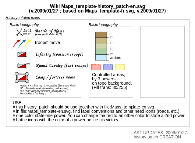
English: Template for the creation of geographic and topographic maps with the most common features used, following the current convention in WP-fr, and for some elements also in part of WP-de. Français : Modèle pour la création de cartes géographiques et topographiques avec les principaux éléments habituellement employés et qui suit les conventions cartographiques actuelles de WP-fr et pour certains éléments en partie dans WP-de. |
| 日期 | (UTC) |
| 來源 | Maps template-fr.svg |
| 作者 |
|
| 這是一張修飾過的圖片,即本圖片是用軟體修改過後的版本,修改的方式或內容有:Select some icones, order them : create an history_patch。原版圖片來源:Maps template-fr.svg。修改者:Yug。
|
授權條款
我,本作品的著作權持有者,決定用以下授權條款發佈本作品:
此檔案採用創用CC 姓名標示 2.5 通用版授權條款。
- 您可以自由:
- 分享 – 複製、發佈和傳播本作品
- 重新修改 – 創作演繹作品
- 惟需遵照下列條件:
- 姓名標示 – 您必須指名出正確的製作者,和提供授權條款的連結,以及表示是否有對內容上做出變更。您可以用任何合理的方式來行動,但不得以任何方式表明授權條款是對您許可或是由您所使用。
此檔案採用創用CC 姓名標示 2.5 通用版授權條款。
- 您可以自由:
- 分享 – 複製、發佈和傳播本作品
- 重新修改 – 創作演繹作品
- 惟需遵照下列條件:
- 姓名標示 – 您必須指名出正確的製作者,和提供授權條款的連結,以及表示是否有對內容上做出變更。您可以用任何合理的方式來行動,但不得以任何方式表明授權條款是對您許可或是由您所使用。

|
已授權您依據自由軟體基金會發行的無固定段落、封面文字和封底文字GNU自由文件授權條款1.2版或任意後續版本,對本檔進行複製、傳播和/或修改。該協議的副本列在GNU自由文件授權條款中。 |
| 此檔案採用共享創意 姓名標示-相同方式分享 3.0 未在地化版本授權條款。 | ||
| ||
| 已新增授權條款標題至此檔案,作為GFDL授權更新的一部份。 |
您可以選擇您需要的授權條款。
原始上傳日誌
This image is a derivative work of the following images:
- File:Maps_template-fr.svg licensed with Cc-by-2.5, Cc-by-2.5, GFDL, GFDL/en
- 2009-01-27T13:06:03Z Yug 1100x1500 (203738 Bytes) MINOR UPDATES: 2009/01/27. Add: port ; bat. judaisme, bat. chinese religions. Correct: terre principal fefee4 -> fefee9 (german usage) Add frames' titles, legend box. Move frames to more suitable place.
- 2008-09-04T00:08:14Z Sting 1100x1500 (176632 Bytes) Several little improvements
- 2008-07-15T14:45:27Z Sting 1100x1500 (170548 Bytes) Some improvements
- 2008-06-24T01:02:19Z Sting 1100x1500 (170673 Bytes) Valors for elevations and depths deleted to avoid confusion
- 2008-06-23T18:53:20Z Sémhur 1100x1500 (170836 Bytes) Change lighthouse icon, and decrease weight
- 2008-06-22T14:26:16Z Sting 1100x1500 (209351 Bytes) Additional topo colors for high elevations/permanent snow areas
- 2008-06-18T13:06:33Z Sting 1100x1500 (202960 Bytes) Additional modifications
- 2008-06-17T02:19:19Z Sting 1100x1500 (202606 Bytes) Some slight modifications
- 2008-06-13T14:51:52Z Sting 1100x1500 (202325 Bytes) Linear scales reduced to one type
- 2008-06-11T22:30:44Z Sting 1100x1500 (331785 Bytes) Some adjustments
- 2008-06-11T03:57:09Z Sting 1100x1500 (324893 Bytes) == Summary == {{Information |Description={{en|Template for the creation of geographic and topographic maps with the most common features used and following the convention to be used in the whole Wikimedia projet. *'''''Import
Uploaded with derivativeFX
檔案歷史
點選日期/時間以檢視該時間的檔案版本。
| 日期/時間 | 縮圖 | 尺寸 | 用戶 | 備註 | |
|---|---|---|---|---|---|
| 目前 | 2009年2月11日 (三) 21:09 | | 820 × 600(104 KB) | Stepshep | typos |
| 2009年1月27日 (二) 15:08 |  | 820 × 600(104 KB) | Yug | oups ^-^"... spelling mistake.... | |
| 2009年1月27日 (二) 15:05 |  | 820 × 600(104 KB) | Yug | {{Information |Description={{en|1=sadfg}} |Source=Own work by uploader |Author=Yug |Date=today |Permission= |other_versions= }} <!--{{ImageUpload|full}}--> |
檔案用途
下列頁面有用到此檔案:
全域檔案使用狀況
以下其他 wiki 使用了這個檔案:
- en.wikipedia.org 的使用狀況
- id.wikipedia.org 的使用狀況
- ru.wikipedia.org 的使用狀況
- sl.wikipedia.org 的使用狀況
- tg.wikipedia.org 的使用狀況