File:Mollweide Cycle.gif
此為最大尺寸。
Mollweide_Cycle.gif (720 × 360 像素,檔案大小:4.33 MB,MIME 類型:image/gif、循環、60 畫格、6.0秒)
摘要
| 描述 |
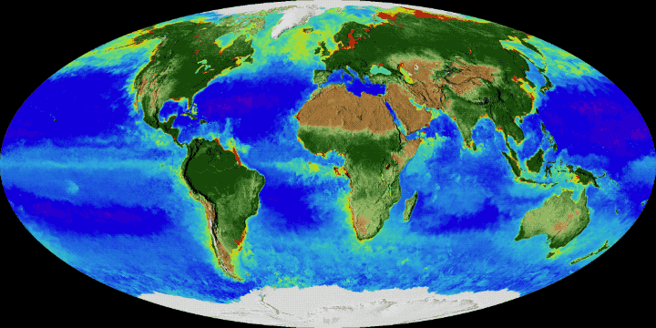
English: On land, vegetation appears on a scale from brown (low vegetation) to dark green (lots of vegetation); at the ocean surface, phytoplankton are indicated on a scale from purple (low) to yellow (high). This visualization was created with data from satellites including SeaWiFS, and instruments including the NASA/NOAA Visible Infrared Imaging Radiometer Suite and the Moderate Resolution Imaging Spectroradiometer.
Français : Cycle annuel de l'enneigement et de la végétation : sur la terre ferme, la végétation apparaît sur une échelle allant du brun (végétation faible ou basse) au vert foncé (végétation dense) ; à la surface de l’océan, la densité en phytoplancton figure sur une échelle allant du violet (faible) au jaune (élevée). Cette visualisation a été créée à l'aide de données provenant de plusieurs satellites, notamment SeaWiFS, et d'instruments tels que la suite de radiomètres infrarouges visibles NASA / NOAA et le spectroradiomètre imageur à résolution moyenne. |
| 日期 | |
| 來源 | NASA's Goddard Space Flight Center |
| 作者 | NASA's Goddard Space Flight Center |
授權條款
| 本作品由NASA創作,屬於公有領域。根據NASA的版權政策:“NASA的創作除非另有聲明否則不受版權保護。”(參見:Template:PD-USGov/zh,NASA版權政策或JPL圖像使用政策) | ||
 |
警告:
|
檔案歷史
點選日期/時間以檢視該時間的檔案版本。
| 日期/時間 | 縮圖 | 尺寸 | 用戶 | 備註 | |
|---|---|---|---|---|---|
| 目前 | 2017年11月15日 (三) 10:18 | | 720 × 360(4.33 MB) | Originalwana | User created page with UploadWizard |
檔案用途
下列頁面有用到此檔案:
全域檔案使用狀況
以下其他 wiki 使用了這個檔案:
- ar.wikipedia.org 的使用狀況
- az.wikipedia.org 的使用狀況
- en.wikipedia.org 的使用狀況
- eu.wikipedia.org 的使用狀況
- fr.wikipedia.org 的使用狀況
- gl.wikipedia.org 的使用狀況
- ja.wikipedia.org 的使用狀況
- jv.wikipedia.org 的使用狀況
- ko.wikipedia.org 的使用狀況
- mdf.wikipedia.org 的使用狀況
- no.wikipedia.org 的使用狀況
- sr.wikipedia.org 的使用狀況
- tr.wikipedia.org 的使用狀況
- uz.wikipedia.org 的使用狀況
- vi.wikipedia.org 的使用狀況