File:North Indian cyclone tracks 1970-2005.jpg

預覽大小:800 × 454 像素。 其他解析度:320 × 182 像素 | 640 × 363 像素 | 1,024 × 581 像素 | 1,280 × 727 像素 | 2,943 × 1,671 像素。
原始檔案 (2,943 × 1,671 像素,檔案大小:1.19 MB,MIME 類型:image/jpeg)
摘要
| Saffir-Simpson Hurricane Scale | ||||||
| TD | TS | 1 | 2 | 3 | 4 | 5 |
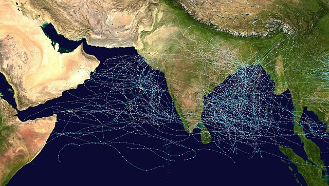
This map shows the tracks of all Tropical cyclones which formed in the north Indian Ocean, or moved into that basin from the northwest Pacific Ocean, from 1970 to 2005. The points show the locations of the storms at six-hourly intervals and use the color scheme shown to the right from Saffir-Simpson Hurricane Scale. Gray points denote unknown strength storms.
授權條款
Created using User:jdorje/Tracks by Nilfanion on 2006-08-16. Background image from Image:Whole_world_-_land_and_oceans.jpg (NASA).
Tracking data for storms is from the Joint Typhoon Warning Center.[1]
| 我,此作品的版權所有人,釋出此作品至公共領域。此授權條款在全世界均適用。 這可能在某些國家不合法,如果是的話: 我授予任何人有權利使用此作品於任何用途,除受法律約束外,不受任何限制。 |
檔案歷史
點選日期/時間以檢視該時間的檔案版本。
| 日期/時間 | 縮圖 | 尺寸 | 用戶 | 備註 | |
|---|---|---|---|---|---|
| 目前 | 2006年8月16日 (三) 15:08 | | 2,943 × 1,671(1.19 MB) | Nilfanion | == Summary == {|align="{{{align|right}}}" border="0" cellspacing="0" cellpadding="0" style="background:transparent;text-align:center" |- |colspan="7" nowrap="nowrap"| <small>Saffir-Simpson Hurricane Scale</small> |- |s |
檔案用途
下列39個頁面有用到此檔案:
- 1990年北印度洋氣旋季
- 1991年北印度洋氣旋季
- 1992年北印度洋氣旋季
- 1993年北印度洋氣旋季
- 1994年北印度洋氣旋季
- 1995年北印度洋氣旋季
- 1996年北印度洋氣旋季
- 1997年北印度洋氣旋季
- 1998年北印度洋氣旋季
- 1999年北印度洋氣旋季
- 2000年北印度洋氣旋季
- 2001年北印度洋氣旋季
- 2002年北印度洋氣旋季
- 2003年北印度洋氣旋季
- 2004年北印度洋氣旋季
- 2005年北印度洋氣旋季
- 2006年北印度洋氣旋季
- 2007年北印度洋氣旋季
- 2008年北印度洋氣旋季
- 2009年北印度洋氣旋季
- 2010年北印度洋氣旋季
- 2011年北印度洋氣旋季
- 2012年北印度洋氣旋季
- 2013年北印度洋氣旋季
- 2014年北印度洋氣旋季
- 2015年北印度洋氣旋季
- 2016年北印度洋氣旋季
- 2017年北印度洋氣旋季
- 2018年北印度洋氣旋季
- 2019年北印度洋氣旋季
- 2020年北印度洋氣旋季
- 2021年北印度洋氣旋季
- 2022年北印度洋氣旋季
- 2023年北印度洋氣旋季
- 2024年北印度洋氣旋季
- 北印度洋氣旋季
- Template:North Indian Ocean cyclone seasons
- Portal:熱帶氣旋
- Portal:熱帶氣旋/風季
全域檔案使用狀況
以下其他 wiki 使用了這個檔案:
- de.wikipedia.org 的使用狀況
- en.wikipedia.org 的使用狀況
- fa.wikipedia.org 的使用狀況
- id.wikipedia.org 的使用狀況
- pt.wikipedia.org 的使用狀況
- simple.wikipedia.org 的使用狀況
- ta.wikipedia.org 的使用狀況
- uk.wikipedia.org 的使用狀況