File:Pico Humboldt.jpg
此為最大尺寸。
Pico_Humboldt.jpg (400 × 262 像素,檔案大小:12 KB,MIME 類型:image/jpeg)
摘要
| 描述 |
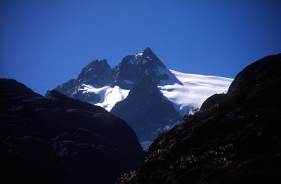
English: Northern side of Humboldt Peak (Pico Humboldt) as seen from the Coromoto-La Verde trail, Venezuelan Andes. |
| 日期 | |
| 來源 | Originally uploaded to English Wikipedia as en:File:Humboldt-peak.jpg |
| 作者 | Mario dos Reis |
| 拍攝地點 | | 位於此地的本圖片與其他圖片: OpenStreetMap |
|---|
授權條款
| 我,此作品的版權所有人,釋出此作品至公共領域。此授權條款在全世界均適用。 這可能在某些國家不合法,如果是的話: 我授予任何人有權利使用此作品於任何用途,除受法律約束外,不受任何限制。 |
檔案歷史
點選日期/時間以檢視該時間的檔案版本。
| 日期/時間 | 縮圖 | 尺寸 | 用戶 | 備註 | |
|---|---|---|---|---|---|
| 目前 | 2009年7月18日 (六) 06:17 | | 400 × 262(12 KB) | TCY | {{Information |Description= Northern side of Humboldt Peak (''Pico Humboldt'') as seen from the Coromoto-La Verde trail, Venezuelan Andes. |Source=Wikipedia in anglish en:File:Humboldt-peak.jpg |Date=January 2001 |Author=Mario dos Reis |Permission= | |
檔案用途
下列頁面有用到此檔案:
全域檔案使用狀況
以下其他 wiki 使用了這個檔案:
- arz.wikipedia.org 的使用狀況
- br.wikipedia.org 的使用狀況
- ca.wikipedia.org 的使用狀況
- ceb.wikipedia.org 的使用狀況
- ckb.wikipedia.org 的使用狀況
- de.wikipedia.org 的使用狀況
- en.wikipedia.org 的使用狀況
- en.wikiversity.org 的使用狀況
- eo.wikipedia.org 的使用狀況
- es.wikipedia.org 的使用狀況
- eu.wikipedia.org 的使用狀況
- fr.wikipedia.org 的使用狀況
- hr.wikipedia.org 的使用狀況
- hu.wikipedia.org 的使用狀況
- ka.wikipedia.org 的使用狀況
- ko.wikipedia.org 的使用狀況
- lld.wikipedia.org 的使用狀況
- lt.wikipedia.org 的使用狀況
- mt.wikipedia.org 的使用狀況
- nl.wikipedia.org 的使用狀況
- os.wikipedia.org 的使用狀況
- pl.wikipedia.org 的使用狀況
- pt.wikipedia.org 的使用狀況
- sh.wikipedia.org 的使用狀況
- simple.wikipedia.org 的使用狀況
- sv.wikipedia.org 的使用狀況
- ta.wikipedia.org 的使用狀況
- vep.wikipedia.org 的使用狀況
- vi.wikipedia.org 的使用狀況
- www.wikidata.org 的使用狀況