原始檔案 (894 × 899 像素,檔案大小:39 KB,MIME 類型:image/png )
Español:
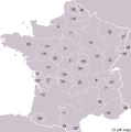
Pre-Republican provinces of France , numbered according to union with France , with provincial capitals marked.
Created by reference to a 1952 Nouveau Petit Larousse by User:OwenBlacker and licenced under the GFDL .
Provinces as follows, in the format English name (French name , Year of union; Capital):
Royal Domain (Île-de-France 987 , Paris )Berry (Berry 1101 , Bourges )Duchy of Orléanais (Orléanais 1198 , Orléans )Normandy (Normandie 1204 , Rouen )Languedoc , mainly the County of Toulouse (Languedoc 1270 , Toulouse )Lyonnais (Lyonnais 1313 , Lyon )Dauphiné , (Dauphiné 1349 , Grenoble )County of Champagne (Champagne 1361 , Troyes )Aunis , a fief of Aquitaine (Aunis 1371 , La Rochelle )Saintonge (Saintonge 1371 , Saintes )Poitou (Poitou 1416 , Poitiers )Duchy of Aquitaine (Aquitaine 1453 , Bordeaux ), taken from England and split into provinces of Gascogne (Armagnac ) and Guyenne (Bordeaux ), but excluding the viscounties of Foix, Béarn, Bigorre and Périgord (kept by Navarre )Duchy of Burgundy (Bourgogne 1477 , Dijon )Picardy (Picardie 1482 , Amiens )Anjou (Anjou 1482 , Angers )County of Provence (Provence 1482 , Aix-en-Provence )County of Angoulême (Angoumois 1515 , Angoulême )Duchy of Bourbon (Bourbonnais 1527 , Moulins )La Marche (Marche 1527 , Guéret )Duchy of Britanny (Bretagne 1532 , Rennes )County of Maine (Maine 1584 , Le Mans ) and County of Perche (Perche 1525 , Nogent-le-Rotrou )Touraine (Touraine 1584 , Tours )Limousin (Limousin 1589 , Limoges ), excluding Viscounty of Périgord (kept by Navarre )County of Foix (Comté de Foix 1607 , Foix ) and Viscounty of Périgord (Périgord , 1607, Périgueux , attached to province of Guyenne), both former fiefs from NavarreDuchy of Auvergne (Auvergne 1610 , Clermont-Ferrand )Viscounty of Béarn (Béarn 1620 , Pau )Alsace (Alsace 1648 , Strasbourg )County of Artois , a fief of the w:Habsburgs ' Spanish Netherlands (Artois 1659 , Arras )Roussillon (Roussillon 1659 , Perpignan )Flanders , a fief of the w:Habsburgs ' Spanish Netherlands (Flandre 1668 , Lille )Free County of Burgundy (Franche-Comté 1678 , Besançon )Duchy of Lorraine , a personal territory of Stanisław I of Poland within the Holy Roman Empire (Lorraine 1766 , Nancy )Corsica (off map, Corse 1768 , Ajaccio )The following were not provinces of France before the Revolution, but joined or were annexed to France after it, when departments had replaced all former provinces: Duchy of Nivernais (Nivernais 1789 , Nevers )Comtat Venaissin , a Papal fief (Comtat Venaissain 1791 , Avignon )Imperial Free City of Mulhouse (Mulhouse 1798 )Duchy of Savoy , a state of the Kingdom of Sardinia-Piedmont (Savoie 1860 , Chambéry )County of Nice , a state of the Kingdom of Sardinia-Piedmont (Comté de Nice 1860 , Nice )Principality of Montbéliard (Montbéliard 1816 , Montbéliard )Free cities of Menton and Roquebrune (1861 ), joining France after the separation (under the protectorate of Sardinia ) in 1848 from Monaco
已授權您依據自由軟體基金會 發行的無固定段落、封面文字和封底文字GNU自由文件授權條款 GNU自由文件授權條款 中。http://www.gnu.org/copyleft/fdl.html GFDL GNU Free Documentation License true true
此檔案採用共享創意 姓名標示-相同方式分享 3.0 未在地化版本 授權條款。
您可以自由:
分享 – 複製、發佈和傳播本作品重新修改 – 創作演繹作品
惟需遵照下列條件:
姓名標示 – 您必須指名出正確的製作者,和提供授權條款的連結,以及表示是否有對內容上做出變更。您可以用任何合理的方式來行動,但不得以任何方式表明授權條款是對您許可或是由您所使用。相同方式分享 – 如果您利用本素材進行再混合、轉換或創作,您必須基於如同原先的相同或兼容的條款 ,來分布您的貢獻成品。
已新增授權條款標題至此檔案,作為GFDL授權更新 的一部份。 http://creativecommons.org/licenses/by-sa/3.0/ CC BY-SA 3.0 Creative Commons Attribution-Share Alike 3.0 true true
derivative works
Derivative works of this file: Forteresses marches de Bretagne.png
檔案歷史
檔案用途
全域檔案使用狀況
以下其他 wiki 使用了這個檔案:
an.wikipedia.org 的使用狀況
ar.wikipedia.org 的使用狀況
檢視此檔案的更多全域使用狀況 。


