File:Radar loop of Typhoon Haiyan (Yolanda) making landfall on Leyte Island.gif
預覽大小:600 × 600 像素。 其他解析度:240 × 240 像素 | 622 × 622 像素。
原始檔案 (622 × 622 像素,檔案大小:1.13 MB,MIME 類型:image/gif、循環、19 畫格、9.5秒)
_making_landfall_on_Leyte_Island.gif?uselang=zh-mo)
_making_landfall_on_Leyte_Island.gif?uselang=zh-mo)
_making_landfall_on_Leyte_Island.gif?action=history&uselang=zh-mo)
_making_landfall_on_Leyte_Island.gif)
摘要
| 描述 |
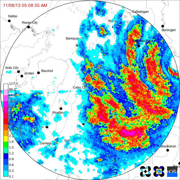
English: Loop of doppler radar imagery showing Typhoon Yolanda/Haiyan's second Philippine landfall, on the island of Leyte. The PAGASA Cebu City radar site began to transmit intermittently as the typhoon neared, eventually failing altogether (last frame).
|
| 日期 | |
| 來源 | http://www.pagasa.dost.gov.ph/ |
| 作者 | PAGASA |
授權條款
| 本作品位於菲律賓的公有領域,以及可能的其他司法管轄區,因為它是由以下機構的官員或僱員創作的作品菲律賓政府或其任何分部和機構,包括政府擁有和/或控制的公司,作為他的一部分定期規定的公務;因此,根據「第四部分第一章第171.11節」和「第四部分第四章第176節」第8293號共和國法和共和國法第10372號,經修訂,除非另有說明。 但是,在某些情況下,在菲律賓或其他地方使用本作品可能受本法律或其他法律的約束。
|

|
檔案歷史
點選日期/時間以檢視該時間的檔案版本。
| 日期/時間 | 縮圖 | 尺寸 | 用戶 | 備註 | |
|---|---|---|---|---|---|
| 目前 | 2013年11月14日 (四) 10:40 | | 622 × 622(1.13 MB) | Chilledsunshine | compressed to acceptable size |
| 2013年11月14日 (四) 09:36 |  | 600 × 600(4.21 MB) | Chilledsunshine | User created page with UploadWizard |
檔案用途
下列頁面有用到此檔案:
全域檔案使用狀況
以下其他 wiki 使用了這個檔案:
- de.wikipedia.org 的使用狀況
- en.wikipedia.org 的使用狀況
- ja.wikipedia.org 的使用狀況
- tl.wikipedia.org 的使用狀況
_making_landfall_on_Leyte_Island.gif)