File:Vanatinai, Louisiade Archipelago.jpg

預覽大小:800 × 533 像素。 其他解析度:320 × 213 像素 | 640 × 427 像素 | 1,024 × 683 像素 | 1,280 × 853 像素 | 2,560 × 1,707 像素 | 3,600 × 2,400 像素。
原始檔案 (3,600 × 2,400 像素,檔案大小:2.93 MB,MIME 類型:image/jpeg)
摘要
| 描述 |
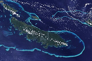
English: The lower corner of the scene shows part of the northwestern coast of the largest island in the archipelago, Vanatinai. Most of the island is densely covered in lowland rainforest, but clearing for agricultural land is widespread around the perimeter, especially in the northwest. The shallow waters covering an extensive network of reefs are electric blue. A sinuous channel of deep, clear water (image center) connects a partially enclosed lagoon north of Vanatinai with the bay south of Yeina Island. |
| 日期 | |
| 來源 | NASA Earth Observatory |
| 作者 | NASA image by Jesse Allen and Rob Simmon, using data provided by the United States Geological Survey. |
Instrument: Landsat 7 - ETM+
授權條款
| 本作品由NASA創作,屬於公有領域。根據NASA的版權政策:“NASA的創作除非另有聲明否則不受版權保護。”(參見:Template:PD-USGov/zh,NASA版權政策或JPL圖像使用政策) | ||
 |
警告:
|
檔案歷史
點選日期/時間以檢視該時間的檔案版本。
| 日期/時間 | 縮圖 | 尺寸 | 用戶 | 備註 | |
|---|---|---|---|---|---|
| 目前 | 2009年4月26日 (日) 12:34 | | 3,600 × 2,400(2.93 MB) | Originalwana | {{Information |Description={{en|1=The lower corner of the scene shows part of the northwestern coast of the largest island in the archipelago, Vanatinai. Most of the island is densely covered in lowland rainforest, but clearing for agricultural land is wi |
檔案用途
全域檔案使用狀況
以下其他 wiki 使用了這個檔案:
- ar.wikipedia.org 的使用狀況
- arz.wikipedia.org 的使用狀況
- ca.wikipedia.org 的使用狀況
- ceb.wikipedia.org 的使用狀況
- cy.wikipedia.org 的使用狀況
- de.wikipedia.org 的使用狀況
- en.wikipedia.org 的使用狀況
- eo.wikipedia.org 的使用狀況
- es.wikipedia.org 的使用狀況
- et.wikipedia.org 的使用狀況
- fa.wikipedia.org 的使用狀況
- fi.wikipedia.org 的使用狀況
- fr.wikipedia.org 的使用狀況
- he.wikipedia.org 的使用狀況
- ia.wikipedia.org 的使用狀況
- id.wikipedia.org 的使用狀況
- it.wikipedia.org 的使用狀況
- kw.wikipedia.org 的使用狀況
- lv.wikipedia.org 的使用狀況
- nl.wikipedia.org 的使用狀況
- pap.wikipedia.org 的使用狀況
- pl.wikipedia.org 的使用狀況
- simple.wikipedia.org 的使用狀況
- uk.wikipedia.org 的使用狀況
- vi.wikipedia.org 的使用狀況
- vls.wikipedia.org 的使用狀況
- www.wikidata.org 的使用狀況