File:1844 Map of Fort William and Esplanade.jpg
此为最大尺寸。
1844_Map_of_Fort_William_and_Esplanade.jpg (640 × 480像素,文件大小:150 KB,MIME类型:image/jpeg)
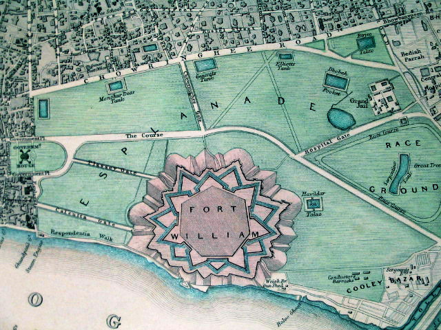
摘要
| 描写 |
Fort William in its context, in an SDUK ("Society for the Diffusion of Useful Knowledge") map from 1844 |
|||||||||
| 日期 | ||||||||||
| 来源 | www.columbia.edu | |||||||||
| 创作作者 |
Society for the Diffusion of Useful Knowledge |
|||||||||
| Geotemporal data | ||||||||||
| 边框 |
|
|||||||||
| 地理参考 | ||||||||||
许可协议
|
本作品在其来源国以及其他著作权期限是作者逝世后70年或以下的国家和地区属于公有领域。 | |
| 本文件已被确认为免除已知的著作权法限制(包括所有相关权利)。 | |
文件历史
点击某个日期/时间查看对应时刻的文件。
| 日期/时间 | 缩略图 | 大小 | 用户 | 备注 | |
|---|---|---|---|---|---|
| 当前 | 2011年2月9日 (三) 18:14 | | 640 × 480(150 KB) | Quibik | Color balance and contrast. |
| 2010年2月5日 (五) 09:01 |  | 640 × 480(115 KB) | Jayantanth | == Summary == {{Information |Description=Fort William in its context, in an SDUK ("Society for the Diffusion of Useful Knowledge") map from 1844 |Source=http://www.columbia.edu/itc/mealac/pritchett/00routesdata/1600_1699/calcutta/fortwilliam/fortwilliam.h |
文件用途
以下页面使用本文件:
全域文件用途
以下其他wiki使用此文件:
- ar.wikipedia.org上的用途
- bn.wikipedia.org上的用途
- en.wikipedia.org上的用途
- es.wikipedia.org上的用途
- fr.wikipedia.org上的用途
- ja.wikipedia.org上的用途
- kn.wikipedia.org上的用途
- ml.wikipedia.org上的用途
- no.wikipedia.org上的用途
- sat.wikipedia.org上的用途
- ta.wikipedia.org上的用途