File:ArnoldExpeditionRouteMarked.jpg

本预览的尺寸:242 × 600像素。 其他分辨率:97 × 240像素 | 193 × 480像素 | 310 × 768像素 | 413 × 1,024像素 | 2,240 × 5,552像素。
原始文件 (2,240 × 5,552像素,文件大小:3.07 MB,MIME类型:image/jpeg)
摘要
| 描述 |
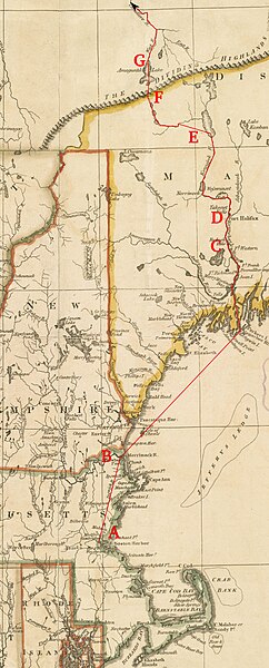
English: This is a detail from a 1795 map depicting the New England states. It is marked with the route of Benedict Arnold's expedition to Quebec City in September 1775.
Legend:
|
| 日期 | base map published by Henry Delahoy Symonds of New England in 1795, markings 2010 |
| 来源 | Source map from the Boston Public Library Map Collection |
| 作者 | John Russell (underlying map), User:Magicpiano (markings) |
许可协议
| 我,本作品著作权人,释出本作品至公有领域。这适用于全世界。 在一些国家这可能不合法;如果是这样的话,那么: 我无条件地授予任何人以任何目的使用本作品的权利,除非这些条件是法律规定所必需的。 |
文件历史
点击某个日期/时间查看对应时刻的文件。
| 日期/时间 | 缩略图 | 大小 | 用户 | 备注 | |
|---|---|---|---|---|---|
| 当前 | 2010年6月18日 (五) 17:08 | 2,240 × 5,552(3.07 MB) | Magicpiano | Use a different base map. | |
| 2009年4月19日 (日) 19:21 |  | 2,618 × 4,631(4.21 MB) | Magicpiano | {{Information |Description={{en|1=This is a detail from a 1780 map depicting the New England states. It is marked with the route of w:Benedict Arnold's expedition to w:Quebec City in September 1775. Legend: *A: [[w:Camb |
文件用途
以下页面使用本文件:
全域文件用途
以下其他wiki使用此文件:
- en.wikipedia.org上的用途
- fr.wikipedia.org上的用途
- it.wikipedia.org上的用途
- ja.wikipedia.org上的用途
- ru.wikipedia.org上的用途
- www.wikidata.org上的用途