File:Azerbaijan location map.svg

此SVG文件的PNG预览的大小:512 × 392像素。 其他分辨率:314 × 240像素 | 627 × 480像素 | 1,003 × 768像素 | 1,280 × 980像素 | 2,560 × 1,960像素。
原始文件 (SVG文件,尺寸为512 × 392像素,文件大小:156 KB)
摘要
| 描述 |
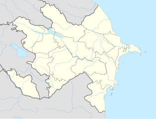
English: Location map of Azerbaijan. Borders of 1994-2020
Equirectangular projection. Strechted by 131.0%. Geographic limits of the map: * N: 42.0° N * S: 38.2° N * W: 44.5° E * E: 51.0° EMade with Natural Earth. Free vector and raster map data @ naturalearthdata.com. |
| 日期 | |
| 来源 | 自己的作品 |
| 作者 | Uwe Dedering, Don-kun |
| 其他版本 |
|


许可协议
我,本作品著作权人,特此采用以下许可协议发表本作品:
本文件采用知识共享署名-相同方式共享 3.0 未本地化版本许可协议授权。
- 您可以自由地:
- 共享 – 复制、发行并传播本作品
- 修改 – 改编作品
- 惟须遵守下列条件:
- 署名 – 您必须对作品进行署名,提供授权条款的链接,并说明是否对原始内容进行了更改。您可以用任何合理的方式来署名,但不得以任何方式表明许可人认可您或您的使用。
- 相同方式共享 – 如果您再混合、转换或者基于本作品进行创作,您必须以与原先许可协议相同或相兼容的许可协议分发您贡献的作品。

|
已授权您依据自由软件基金会发行的无固定段落及封面封底文字(Invariant Sections, Front-Cover Texts, and Back-Cover Texts)的GNU自由文件许可协议1.2版或任意后续版本的条款,复制、传播和/或修改本文件。该协议的副本请见“GNU Free Documentation License”。 |
您可以选择您需要的许可协议。
文件历史
点击某个日期/时间查看对应时刻的文件。
| 日期/时间 | 缩略图 | 大小 | 用户 | 备注 | |
|---|---|---|---|---|---|
| 当前 | 2024年1月10日 (三) 16:48 | | 512 × 392(156 KB) | Janitoalevic | Economic Regions |
| 2016年5月5日 (四) 08:09 |  | 1,200 × 919(227 KB) | Rs4815 | Reverted to version as of 16:20, 21 April 2016 (UTC) | |
| 2016年5月3日 (二) 22:22 |  | 1,200 × 919(217 KB) | Taron Saharyan | нет достоверных данных, вы переместили границу на 1 км. чуть ли не по всей линии, это бред | |
| 2016年4月21日 (四) 16:20 |  | 1,200 × 919(227 KB) | Don-kun | fix karabakh border | |
| 2016年4月17日 (日) 09:46 |  | 1,200 × 919(227 KB) | Don-kun | fix border to karabakh | |
| 2016年4月13日 (三) 16:46 |  | 1,200 × 919(217 KB) | Don-kun | Jojug Marjanli now to Azerbaijan (region seemed to be a bit wrong before ...) and tried to fix some other parts of NKR-AZ-Border | |
| 2010年6月7日 (一) 19:43 |  | 1,200 × 919(217 KB) | Don-kun | correct borders of rayons; hole area under karabakh control, not the former Nagorno-Karabakh Autonomous Oblast | |
| 2010年2月19日 (五) 13:11 |  | 1,200 × 919(244 KB) | Uwe Dedering | Nagorno-Karabakh not grey, but visible | |
| 2010年2月18日 (四) 17:58 |  | 1,200 × 919(244 KB) | Uwe Dedering | but really with dagestan | |
| 2010年2月18日 (四) 17:42 |  | 1,200 × 919(233 KB) | Uwe Dedering | Dagestan and parts of Armenia saved from drowning, Nagorno-Karabakh now under the region-borders. |
文件用途
没有页面使用本文件。
全域文件用途
以下其他wiki使用此文件:
- bn.wikipedia.org上的用途
- ckb.wikipedia.org上的用途
- de.wikipedia.org上的用途
- fy.wikipedia.org上的用途
- he.wikipedia.org上的用途