原始文件 (4,645 × 4,399像素,文件大小:2.21 MB,MIME类型:image/png


摘要

描述
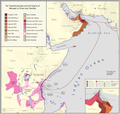
English: A highly detailed english chronological map of the yarubid imamate and albusaid empire and sultanates in Oman and Zanzibar
日期
来源

Own work based on:

- https://www.worldstatesmen.org/Mozambique_native.html

- (Newitt, Malyn. A History of Mozambique. Indiana University Press, Bloomington, IN, 1995.)

- https://www.worldstatesmen.org/Tanzania_native.html

- https://www.worldstatesmen.org/Kenya_native.html

- https://understandingthehorn.berkeley.edu/horn-africa-1730-ce (uses - https://operationoverload.wordpress.com/category/mogadishu/)

- https://books.google.com.eg/books?id=WixiTjxYdkYC&pg=PA521&redir_esc=y#v=onepage&q&f=false

- https://en.wikipedia.org/wiki/Sultanate_of_Zanzibar

- (https://www.worldcat.org/title/zanzibar-its-history-and-its-people/oclc/186237036)

- (https://archive.org/details/africanaencyclop00appi)

- (http://www.heliograph.com/trmgs/trmgs2/bea.shtml)

- (http://hansard.millbanksystems.com/commons/1895/jun/13/british-east-africa#S4V0034P0_18950613_HOC_216)

- (https://books.google.com.eg/books?id=2WOuAAAAIAAJ&redir_esc=y)

- https://en.wikipedia.org/wiki/East_Africa_Protectorate

- (https://www.fotw.info/flags/eaf-brit.html#%3Cww1)

- https://en.wikipedia.org/wiki/Rumaliza - https://commons.wikimedia.org/wiki/File:Stanley_Founding_of_Congo_Free_State_365_Political_Divisions_of_the_Congo_Basin.jpg

- hisatlas

- other sources, books, jstor papers

- Tubinger's Atlas

- Journal of African Studies

Sources that confirm the map:

- The Cambridge History of Africa Vol. 5, p. 275

- Oman in History. pp. 445-463

- Muqdisho in the Nineteenth Century: A Regional Perspective. The Journal of African History, Vol. 24, No. 4 (1983), pp. 441-459

- The Swahili Coast: Politics, Diplomacy and Trade on the East African Littoral, 1798-1856

- Somalia: Nation in Search of a State

- Gazetteer of the Persian Gulf, Oman and Central Arabia. Volume 1. John Gordon Lorimer
作者 Abdurrahman AbdulMoneim & RETF

许可协议

我,本作品著作权人,特此采用以下许可协议发表本作品:
w:zh:知识共享
署名 相同方式共享
本文件采用知识共享署名-相同方式共享 4.0 国际许可协议授权。
您可以自由地:
  • 共享 – 复制、发行并传播本作品
  • 修改 – 改编作品
惟须遵守下列条件:
  • 署名 – 您必须对作品进行署名,提供授权条款的链接,并说明是否对原始内容进行了更改。您可以用任何合理的方式来署名,但不得以任何方式表明许可人认可您或您的使用。
  • 相同方式共享 – 如果您再混合、转换或者基于本作品进行创作,您必须以与原先许可协议相同或相兼容的许可协议分发您贡献的作品。

说明

添加一行文字以描述该文件所表现的内容
Chronological map of the Omani empire

此文件中描述的项目

描绘内容

创作作者 简体中文(已转写)

某些值没有维基数据项目

作者姓名字符串 简体中文(已转写):​Abdurrahman AbdulMoneim & RETF
维基媒体用户名 简体中文(已转写):​Userd898

版权状态 简体中文(已转写)

版权所有 简体中文(已转写)

媒体类型 简体中文(已转写)

image/png

文件历史

点击某个日期/时间查看对应时刻的文件。

日期/时间缩⁠略⁠图大小用户备注
当前2023年3月6日 (一) 06:332023年3月6日 (一) 06:33版本的缩略图4,645 × 4,399(2.21 MB)Userd898fixed malawi
2023年3月5日 (日) 15:012023年3月5日 (日) 15:01版本的缩略图4,645 × 4,399(2.2 MB)Userd898fixed another inaccuracy
2023年3月5日 (日) 14:262023年3月5日 (日) 14:26版本的缩略图4,645 × 4,399(2.2 MB)Userd898fixed small inaccuracy
2023年3月5日 (日) 13:102023年3月5日 (日) 13:10版本的缩略图4,645 × 4,399(2.19 MB)Userd898added inset
2023年3月4日 (六) 20:212023年3月4日 (六) 20:21版本的缩略图4,645 × 4,399(2 MB)Userd898Uploaded own work with UploadWizard

以下页面使用本文件:

全域文件用途

以下其他wiki使用此文件:

元数据