File:Poland & The New Baltic States.jpg
本预览的尺寸:462 × 599像素。 其他分辨率:185 × 240像素 | 370 × 480像素 | 592 × 768像素 | 790 × 1,024像素 | 1,376 × 1,784像素。
原始文件 (1,376 × 1,784像素,文件大小:1.22 MB,MIME类型:image/jpeg)
| 描述 |
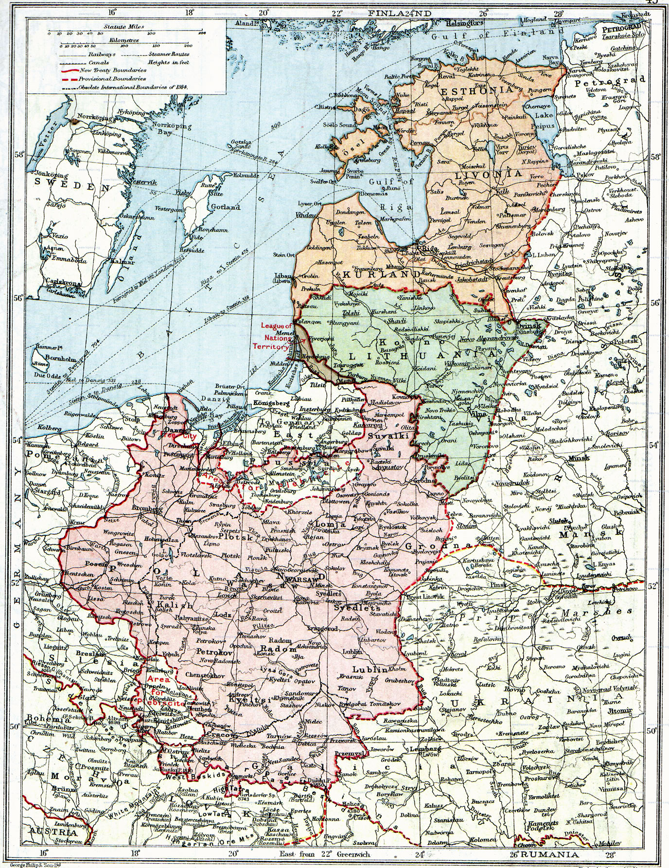
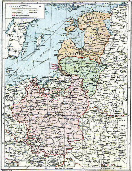
English: Map of Poland, en:Lithuania, en:Courland, en:Livonia and en:Esthonia published in the 1920 edition of The Peoples Atlas by London Geographical Institute.
The map shows the situation after the treaties of Versailles and Brest-Litovsk and before the en:Peace of Riga and the organization and recognition of the nation-states of en:Estonia and en:Latvia. Note that most names featured on this map are pre-1914 Russian names put in English transcription, rather than local or English names as such. |
| 日期 | |
| 来源 |
This uploaded map is a photoshopped version of the original image located at Image:London-geographical-institute the-peoples-atlas 1920 poland-and-the-new-baltic-states.jpg or [1]. Originally uploaded to EN Wikipedia as en:Image:Poland & The New Baltic States.jpg by en:User:MaGioZal 26 December 2007 |
| 作者 | London Geographical Institute |
| 授权 (二次使用本文件) |
According to the site, there are no copyrights to this map. |
| 其他版本 | Image:London-geographical-institute the-peoples-atlas 1920 poland-and-the-new-baltic-states.jpg |
|
|
 | |
 |
文件历史
点击某个日期/时间查看对应时刻的文件。
| 日期/时间 | 缩略图 | 大小 | 用户 | 备注 | |
|---|---|---|---|---|---|
| 当前 | 2010年6月26日 (六) 14:06 | | 1,376 × 1,784(1.22 MB) | Ras67 | losslessly cropped with Jpegcrop |
| 2008年8月3日 (日) 07:47 |  | 1,506 × 1,996(1.28 MB) | Rcbutcher | {{Information |Description=Map of Poland, Lithuania, Courland, Livonia and Esthonia published in the 1920 edition of ''The Peoples Atlas'' by London Geographical Institute. The map shows the situation after the treaties of [[Treaty of |
文件用途
以下页面使用本文件:
全域文件用途
以下其他wiki使用此文件:
- ar.wikipedia.org上的用途
- bat-smg.wikipedia.org上的用途
- ba.wikipedia.org上的用途
- ca.wikipedia.org上的用途
- da.wikipedia.org上的用途
- de.wikipedia.org上的用途
- en.wikipedia.org上的用途
- et.wikipedia.org上的用途
- fi.wikipedia.org上的用途
- fr.wikipedia.org上的用途
- gl.wikipedia.org上的用途
- it.wikipedia.org上的用途
- ja.wikipedia.org上的用途
- lt.wikipedia.org上的用途
- lt.wikibooks.org上的用途
- lv.wikipedia.org上的用途
- no.wikipedia.org上的用途
- ro.wikipedia.org上的用途
- ru.wikipedia.org上的用途
- sl.wikipedia.org上的用途
- sr.wikipedia.org上的用途
- sv.wikipedia.org上的用途
查看本文件的更多全域用途。