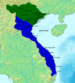
File:Map of Southern and Northern Dynasties of Vietnam.png

本预览的尺寸:487 × 599像素。 其他分辨率:195 × 240像素 | 390 × 480像素 | 650 × 800像素。
原始文件 (650 × 800像素,文件大小:124 KB,MIME类型:image/png)
文件历史
点击某个日期/时间查看对应时刻的文件。
| 日期/时间 | 缩略图 | 大小 | 用户 | 备注 | |
|---|---|---|---|---|---|
| 当前 | 2020年5月19日 (二) 11:17 |  | 650 × 800(124 KB) | A | Upload a to a new name if you want, but don't replace files of other people |
| 2020年5月17日 (日) 00:54 |  | 764 × 843(694 KB) | Zhu Zi Ling | Cities and town added | |
| 2015年9月29日 (二) 19:14 |  | 650 × 800(124 KB) | Denniss | Reverted to version as of 17:11, 25 December 2014 | |
| 2015年9月28日 (一) 13:04 |  | 650 × 800(82 KB) | 昭文館 | =={{int:filedesc}}== {{Information |description={{en|1=Vietnam circa 1570 showing the Mac in control of the land north of the Red river, and the Nguyen-Trinh alliance in control of the southern part of Vietnam. Map data based on "The Empire of Le Than... | |
| 2014年12月25日 (四) 17:11 |  | 650 × 800(124 KB) | TRMC | User created page with UploadWizard |
文件用途
以下页面使用本文件:
全域文件用途
以下其他wiki使用此文件:
- bn.wikipedia.org上的用途
- ceb.wikipedia.org上的用途
- de.wikipedia.org上的用途
- en.wikipedia.org上的用途
- fr.wikipedia.org上的用途
- id.wikipedia.org上的用途
- it.wikipedia.org上的用途
- ja.wikipedia.org上的用途
- ko.wikipedia.org上的用途
- pt.wikipedia.org上的用途
- sl.wikipedia.org上的用途
- uk.wikipedia.org上的用途
- vi.wikipedia.org上的用途
- www.wikidata.org上的用途
