File:Mars Viking 22a002.png

本预览的尺寸:800 × 156像素。 其他分辨率:320 × 62像素 | 640 × 125像素 | 2,626 × 512像素。
原始文件 (2,626 × 512像素,文件大小:361 KB,MIME类型:image/png)
摘要
| 描述 |
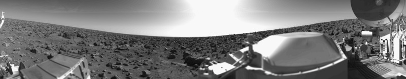
English: Original Caption Released with NASA Image: This rocky panoramic scene is the second picture of the Martian surface that was taken by Viking Lander 2 shortly after touchdown on September 3 at 3:58 PM PDT (Earth received time). The site is on a northern plain of Mars, at about 48 N. Lat., 226 W. Long., known as Utopia Planitia. The picture sweeps around 330 degrees in azimuth, starting from northwest at the left through north (above the sampler arm housing) past east, where the sky is bright at the center, and southeast toward the right above the radioisotope thermoelectric generator cover. The surface is strewn with rocks out to the horizon, ranging in size up to several meters across. Some pitted rocks resemble fragments of porous volcanic lava. Other rocks have grooves that may have been eroded by windblown sand and dust. Although fine-grained material is seen between the boulders, no sand dunes are evident. The dip in the eastern horizon at the center is an illusion caused by an 8-degree tilt of the Lander toward the west. Actually, the terrain is more level than that at the Viking 1 site. The horizon toward the left of the panorama (northwest) appears featureless, indicating that it may be several kilometers distant. The sky at the center (east) is bright because the sun was above but out of the picture at 10 AM Mars time. Toward the right (southeast), the rocks that are silhouetted against the skyline indicate that the horizon is much nearer, probably because of a slight rise in that area of the terrain. The circular high-gain antenna at the right has clots of fine-grained material adhering to the lower half, some of which appeared to have been sliding downward while the camera was scanning the area. At the extreme right, the banded appearance resulted because the camera continued to scan while it was no longer moving in azimuth. Any motion or other variation in the scene would show up as a change in successive lines. |
| 日期 | 2010-02-17; original photo was taken 1977-09-03. |
| 来源 | Own work based on images in the NASA Viking image archive |
| 作者 | "Roel van der Hoorn (Van der Hoorn)" |
| 授权 (二次使用本文件) |
I used the original 22a002.sur image from the NASA Viking image archive, converted it to .png and manually removed the noise. Except for the conversion, this was done in Adobe Photoshop CS2 and Adobe Photoshop CS4. The original file by NASA is in the public domain, and so is this new one. |
| 其他版本 | I created this image as a replacement for the File:Vl2.jpg. This file was created by NASA, but the quality is not very high, especially on the right side. Using the original pictures from the Lander archive resulted in a higher quality image. |
许可协议
| 本作品已被作者英语维基百科的Van der Hoorn释出到公有领域。这适用于全世界。 在一些国家这可能不合法;如果是这样的话,那么: Van der Hoorn无条件地授予任何人以任何目的使用本作品的权利,除非这些条件是法律规定所必需的。 |
The image is based on an original image from NASA to which the following copyright statement is applicable:
| 本文件完全由NASA创作,在美国属于公有领域。根据NASA的版权方针,NASA的材料除非另有声明否则不受版权保护。(参见Template:PD-USGov/zh、NASA版权方针页面或JPL图片使用方针。) | ||
 |
警告:
|
文件历史
点击某个日期/时间查看对应时刻的文件。
| 日期/时间 | 缩略图 | 大小 | 用户 | 备注 | |
|---|---|---|---|---|---|
| 当前 | 2010年2月17日 (三) 00:31 | 2,626 × 512(361 KB) | Van der Hoorn | {{Information |Description={{en|1='''Original Caption Released with NASA Image:'''<br />This rocky panoramic scene is the second picture of the Martian surface that was taken by Viking Lander 2 shortly after touchdown on September 3 at 3:58 PM PDT (Earth |
文件用途
全域文件用途
以下其他wiki使用此文件:
- ca.wikipedia.org上的用途
- de.wikipedia.org上的用途
- en.wikipedia.org上的用途
- es.wikipedia.org上的用途
- fr.wikipedia.org上的用途
- he.wikipedia.org上的用途
- it.wikipedia.org上的用途
- ja.wikipedia.org上的用途
- kk.wikipedia.org上的用途
- lmo.wikipedia.org上的用途
- lt.wikipedia.org上的用途
- ru.wikipedia.org上的用途
- uk.wikipedia.org上的用途
- vi.wikipedia.org上的用途