File:Nazi-Soviet 1941.png
此为最大尺寸。
Nazi-Soviet_1941.png (372 × 460像素,文件大小:78 KB,MIME类型:image/png)

|
此military map图片可使用矢量图形重新创建为SVG文件。这具有很多好处;更多信息请参见共享资源:待清理媒体。如果存在此图片的SVG格式,请将其上传,然后将此模板替换为
{{vector version available|新图片名称}}。
建议您将SVG命名为“Nazi-Soviet 1941.svg”,这样在使用Vector version available(或Vva)模板时就不需要填写新图片名称参数。 |
摘要
| 描述 |
English: From the original en.wikipedia page:
|
| 日期 | 2009年3月9日 (原始上传日期) |
| 来源 | Transferred from en.wikipedia to Commons by Trần Nguyễn Minh Huy. |
| 作者 | 原上传者为英语维基百科的Mosedschurte |
| 其他版本 | Second World War Europe 05 1941 east fr.svg |
许可协议

|
已授权您依据自由软件基金会发行的无固定段落及封面封底文字(Invariant Sections, Front-Cover Texts, and Back-Cover Texts)的GNU自由文件许可协议1.2版或任意后续版本的条款,复制、传播和/或修改本文件。该协议的副本请见“GNU Free Documentation License”。 |
| 本文件采用知识共享署名-相同方式共享 3.0 未本地化版本许可协议授权。 | ||
| ||
| 本许可协议标签作为GFDL许可协议更新的组成部分被添加至本文件。 |

|
免责声明 本图像(或其中包含的符号)在以下国家受法律所禁止,原因是有关符号(以各种方式)表现共产主义、社会主义或类似的政体;或与其相关的政党及组织:格鲁吉亚、拉脱维亚、立陶宛(由宪法法庭通过的行政违法法典第18818条)、乌克兰(刑法第436-1条)、匈牙利(2012年刑法C章第335节)和印度尼西亚。 |

|
免责声明 这张图像呈现(或用来代表)纳粹党、其相关组织或其他被德国联邦宪法法院所禁止的组织使用过的徽章和符号。 在内文使用这些已被查禁组织的徽章(例如纳粹党卐字或箭十字)也会违反奥地利、匈牙利、波兰、捷克、法国、巴西、以色列、乌克兰和俄罗斯等国家的法律。在德国刑法典(StGB)第86a条章节和波兰刑法第256条(Dz.U. 1997 nr 88 poz. 553)内有明文规定。 |
原始上传日志
The original description page was here. All following user names refer to en.wikipedia.
- 2009-03-09 17:05 Mosedschurte 372×460× (79594 bytes) ===English=== * Description: Second world war map on June 1941 * Source: Own map, based on the maps of the [http://www.lib.utexas.edu/maps/ University of Texas Libraries] * Author: [[User:Mosedschurte|Mosedschurte]], February 12, 2009 ===License=== {{GFD
- 2009-02-18 18:26 Mosedschurte 385×479× (64782 bytes) ===English=== * Description: Second world war map on June 1941 * Source: Own map, based on the maps of the [http://www.lib.utexas.edu/maps/ University of Texas Libraries] * Author: [[User:Mosedschurte|Mosedschurte]], February 12, 2009 ===License=== {{GFD
- 2009-02-18 07:13 Mosedschurte 377×447× (62398 bytes) ===English=== * Description: Second world war map on June 1941 * Source: Own map, based on the maps of the [http://www.lib.utexas.edu/maps/ University of Texas Libraries] * Author: [[User:Mosedschurte|Mosedschurte]], February 12, 2009 ===License=== {{GFD
- 2009-02-12 12:54 Mosedschurte 398×468× (64310 bytes) ===English=== * Description: Second world war map on June 1941 * Source: Own map, based on the maps of the [http://www.lib.utexas.edu/maps/ University of Texas Libraries] * Author: [[User:Mosedschurte|Mosedschurte]], February 12, 2009 ===License=== {{GFD
- 2009-02-12 12:50 Mosedschurte 383×463× (63199 bytes) ===English=== * Description: Second world war map on June 1941 * Source: Own map, based on the maps of the [http://www.lib.utexas.edu/maps/ University of Texas Libraries] * Author: [[User:Mosedschurte|Mosedschurte]], February 12, 2009 ===License=== {{GFD
文件历史
点击某个日期/时间查看对应时刻的文件。
| 日期/时间 | 缩略图 | 大小 | 用户 | 备注 | |
|---|---|---|---|---|---|
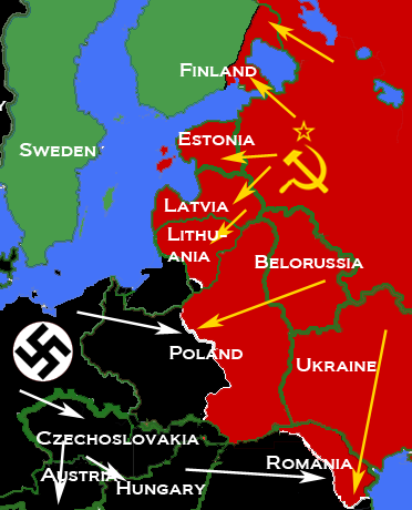
| 当前 | 2010年4月5日 (一) 09:26 | | 372 × 460(78 KB) | Trần Nguyễn Minh Huy | {{Information |Description={{en|* Description: Map depicting most of Central and Eastern Europe, showing 1938 borders, along with Axis (black) and Soviet (red) military and political advances until late 1940. * Source: Own map, based on the maps of the [h |
文件用途
以下页面使用本文件:
全域文件用途
以下其他wiki使用此文件:
- ar.wikipedia.org上的用途
- bn.wikipedia.org上的用途
- bs.wikipedia.org上的用途
- de.wikipedia.org上的用途
- el.wikipedia.org上的用途
- en.wikipedia.org上的用途
- es.wikipedia.org上的用途
- fr.wikipedia.org上的用途
- hr.wikipedia.org上的用途
- id.wikipedia.org上的用途
- lv.wikipedia.org上的用途
- pl.wikipedia.org上的用途
- pt.wikipedia.org上的用途
- ro.wikipedia.org上的用途
- sr.wikipedia.org上的用途
- tl.wikipedia.org上的用途
- uk.wikipedia.org上的用途
- vi.wikipedia.org上的用途
- www.wikidata.org上的用途