File:1263 Mediterranean Sea.svg

此 SVG 檔案的 PNG 預覽的大小:800 × 367 像素。 其他解析度:320 × 147 像素 | 640 × 293 像素 | 1,024 × 469 像素 | 1,280 × 587 像素 | 2,560 × 1,173 像素 | 925 × 424 像素。
原始檔案 (SVG 檔案,表面大小:925 × 424 像素,檔案大小:704 KB)
摘要
| 描述 |
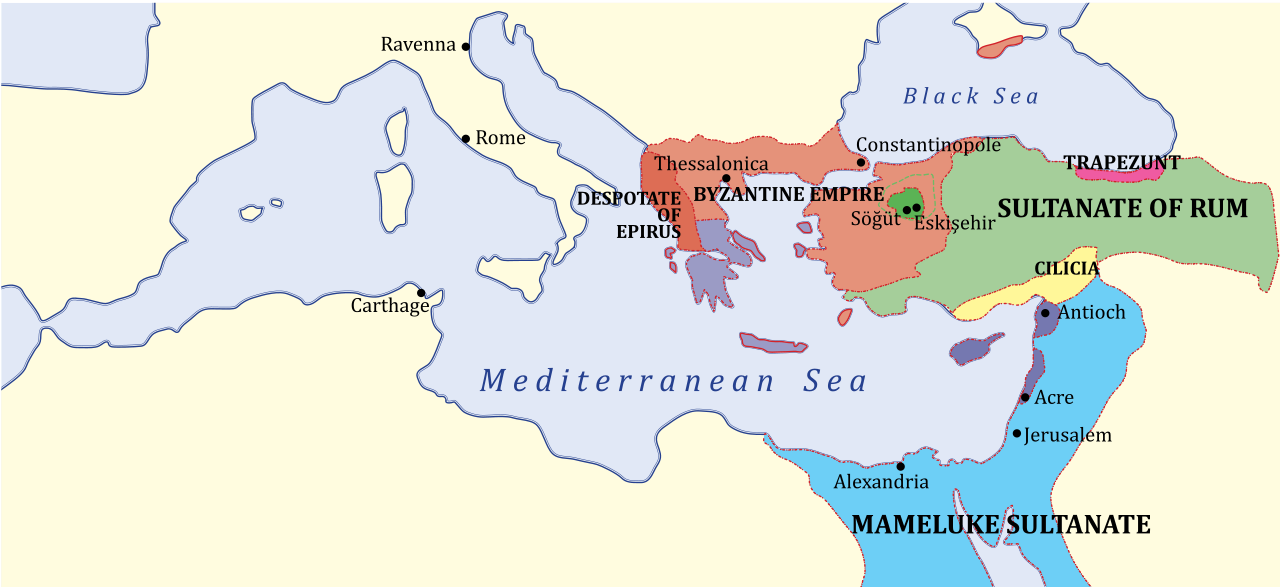
English: Map of Eastern Mediterranean region — with Near East and southeastern Balkans, c. 1263.
|
| 日期 | (UTC) |
| 來源 | |
| 作者 |
|
| 其他版本 |
[]
|


| 這是一張修飾過的圖片,即本圖片是用軟體修改過後的版本,修改的方式或內容有:SVG version。原版圖片來源:1263 Mediterranean Sea.PNG。修改者:Hoodinski。
|
en:Category:Maps of the Byzantine Empire
授權條款
我,本作品的著作權持有者,決定用以下授權條款發佈本作品:
| |
此作品已由其作者,[[::|中文維基百科]]專案的Example,釋出至公有領域。此授權條款在全世界均適用。 如果法律不適用時: |
原始上傳日誌
This image is a derivative work of the following images:
- File:1263_Mediterranean_Sea.PNG licensed with PD-user-w
- 2009-08-31T12:53:31Z Shizhao 801x370 (141734 Bytes) {{Information |Description={{en|Middle East c. 1263. KEY: *Dark Green: Ottoman domain by 1300's, dotted line indicates conquests up to 1326 *Purple: Byzantine Empire (successor of Nicaean Empire) *Light Green: Turk lands, nom
Uploaded with derivativeFX
檔案歷史
點選日期/時間以檢視該時間的檔案版本。
| 日期/時間 | 縮圖 | 尺寸 | 使用者 | 備註 | |
|---|---|---|---|---|---|
| 目前 | 2011年12月10日 (六) 17:08 | | 925 × 424(704 KB) | Hoodinski | == {{int:filedesc}} == {{Information |Description={{en|Middle East c. 1263. KEY: *Dark Green: Ottoman domain by 1300's, dotted line indicates conquests up to 1326 *Purple: Byzantine Empire (successor of Nicaean Empire) *Light Green: Turk lands, nominal va |
檔案用途
全域檔案使用狀況
以下其他 wiki 使用了這個檔案:
- azb.wikipedia.org 的使用狀況
- az.wikipedia.org 的使用狀況
- ba.wikipedia.org 的使用狀況
- bn.wikipedia.org 的使用狀況
- cs.wikipedia.org 的使用狀況
- el.wikipedia.org 的使用狀況
- en.wikipedia.org 的使用狀況
- et.wikipedia.org 的使用狀況
- id.wikipedia.org 的使用狀況
- it.wikipedia.org 的使用狀況
- ko.wikipedia.org 的使用狀況
- mk.wikipedia.org 的使用狀況
- ms.wikipedia.org 的使用狀況
- pl.wikipedia.org 的使用狀況
- rm.wikipedia.org 的使用狀況
- ru.wikipedia.org 的使用狀況
- sk.wikipedia.org 的使用狀況
- sl.wikipedia.org 的使用狀況
- sr.wikipedia.org 的使用狀況
- tr.wikipedia.org 的使用狀況
- uk.wikipedia.org 的使用狀況
- vi.wikipedia.org 的使用狀況