File:20170807 Bolivia 1373 crop Potosí sRGB (37270469644).jpg
原始檔案 (2,700 × 3,599 像素,檔案大小:1.61 MB,MIME 類型:image/jpeg)
.jpg?uselang=zh-tw)
.jpg?uselang=zh-tw)
.jpg?action=history&uselang=zh-tw)
.jpg)
摘要
| 描述 |
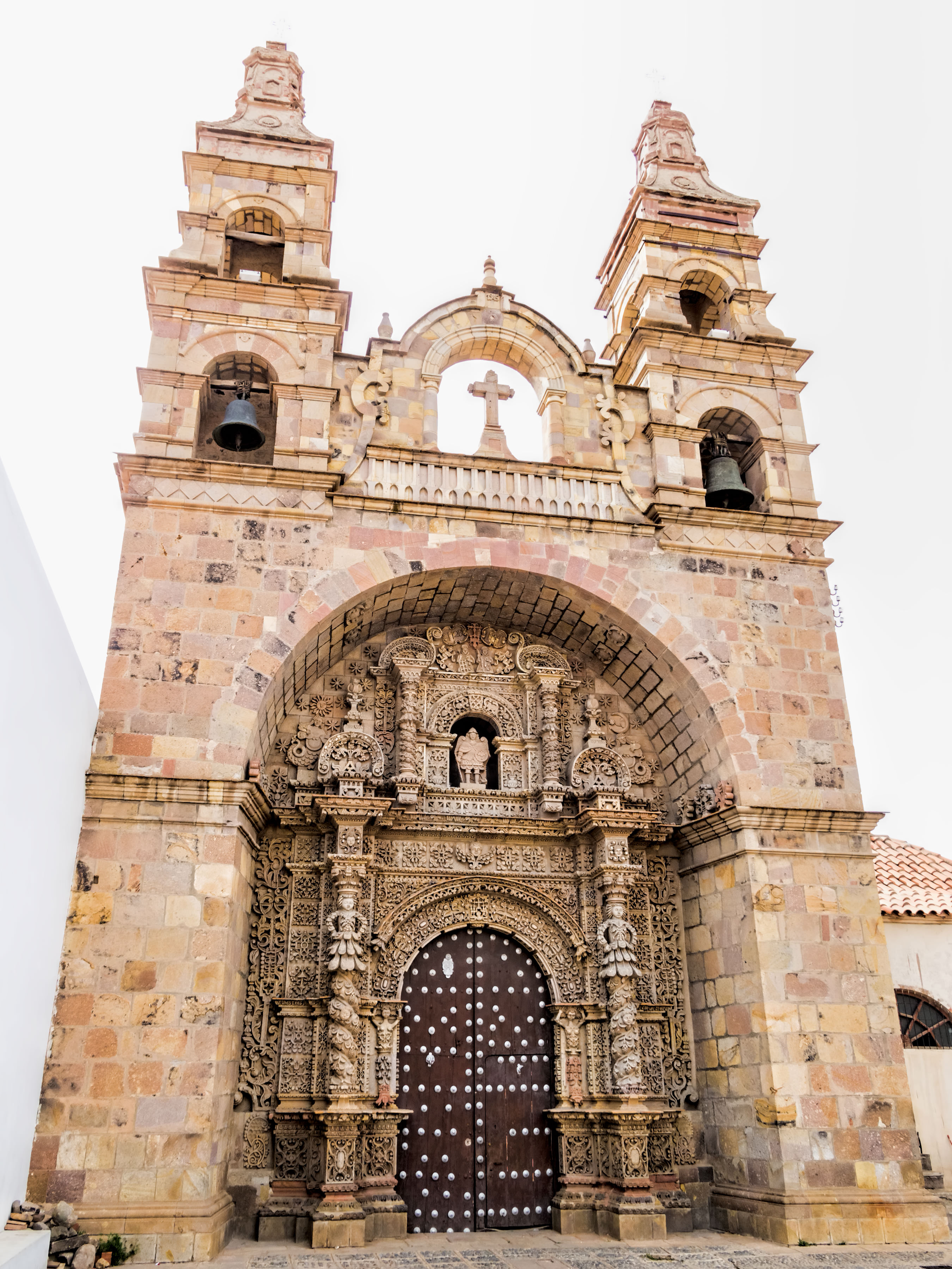
The Church of St. Lawrence of Carangas was built by indigenous people from Carangas, Bolivia, to be their parish church. They had been brought to Potosí to be forced laborers in the silver mine. Construction began in 1548. The church boasts an ornate entrance portal carved in stone by indigenous artisans in a mestizo baroque style. The bell towers were added during extensive remodeling from 1728 to 1744. A renovation was done in 1987. Potosí (elev. 4,090m/13,420ft) [for comparison: Lhasa, Tibet, at 3,658m/12,001ft] was founded in 1545 as a mining town at the foot of Rich Hill (Cerro Rico), the world’s largest silver deposit. An estimated 60% of all silver mined in the world during the second half of the 16th century came from Potosí which was reputed to be the world’s largest industrial complex at the time. Its population eventually exceeded 200,000 people, making it one of the largest cities in the world. Most of the mining and smelting (using mercury) was done by forced labor, both indigenous people and African slaves. As many as 8 million workers are estimated to have died between 1545 and 1825. Output began to decline in the early 19th century. By the 1890s, low silver prices prompted a shift to mining tin. Growing demand for tin this century by the electronics industry has helped the local economy. Silver extraction continues on a small scale. Miguel de Cervantes’ novel “Don Quixote” describes Potosí as a land of “extraordinary richness” (chapter 71 in the second volume which was published in 1615). The City of Potosí was declared a UNESCO World Heritage Site in 1987. On Google Earth: Iglesia de San Lorenzo de Carangas 19°35'12.12"S, 65°45'17.50"W |
| 日期 | |
| 來源 | 20170807_Bolivia_1373 crop Potosí sRGB |
| 作者 | Dan Lundberg |
| 拍攝地點 | | 位於此地的本圖片與其他圖片: OpenStreetMap |
|---|
.jpg¶ms=-19.586936_N_-065.754826_E_globe:Earth_type:camera_source:Flickr_&language=zh-tw)
授權條款
- 您可以自由:
- 分享 – 複製、發佈和傳播本作品
- 重新修改 – 創作演繹作品
- 惟需遵照下列條件:
- 姓名標示 – 您必須指名出正確的製作者,和提供授權條款的連結,以及表示是否有對內容上做出變更。您可以用任何合理的方式來行動,但不得以任何方式表明授權條款是對您許可或是由您所使用。
- 相同方式分享 – 如果您利用本素材進行再混合、轉換或創作,您必須基於如同原先的相同或兼容的條款,來分布您的貢獻成品。
| 這幅圖片原始出處為Flickr的https://flickr.com/photos/9508280@N07/37270469644 ,作者為Dan Lundberg 。經機器人FlickreviewR 2在2017年11月2日審查後確定為採用cc-by-sa-2.0的協議授權使用。 |
檔案歷史
點選日期/時間以檢視該時間的檔案版本。
| 日期/時間 | 縮圖 | 尺寸 | 使用者 | 備註 | |
|---|---|---|---|---|---|
| 目前 | 2017年11月2日 (四) 15:58 | | 2,700 × 3,599(1.61 MB) | Ser Amantio di Nicolao | Transferred from Flickr via Flickr2Commons |
檔案用途
全域檔案使用狀況
以下其他 wiki 使用了這個檔案:
- ar.wikipedia.org 的使用狀況
- dag.wikipedia.org 的使用狀況
- en.wikipedia.org 的使用狀況
- es.wikipedia.org 的使用狀況
- incubator.wikimedia.org 的使用狀況
- ro.wikipedia.org 的使用狀況
- sr.wikipedia.org 的使用狀況
.jpg)