File:Ankara districts.png
此為最大尺寸。
Ankara_districts.png (733 × 600 像素,檔案大小:166 KB,MIME 類型:image/png)
摘要
| 描述 |
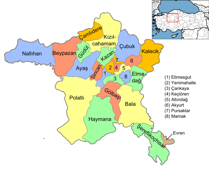
English: Map of the districts of Ankara province of Turkey. Created by Rarelibra 16:37, 1 December 2006 (UTC) for public domain use, using MapInfo Professional v8.5 and various mapping resources. Edited by One Homo Sapiens Corrected text where İ,Ş,ı,ğ,or ş occurs in name. Source: [statoids-com]. Increased font size and enhanced color differences among adjacent districts. |
| 日期 | 2006年12月1日 (原始上傳日期) |
| 來源 | 无法识别来源。根据版权声明推断为其自己的作品。 |
| 作者 | 无法识别作者。根据版权声明推断作者为Rarelibra。 |
授權條款
| 我,此作品的版權所有人,釋出此作品至公共領域。此授權條款在全世界均適用。 這可能在某些國家不合法,如果是的話: 我授予任何人有權利使用此作品於任何用途,除受法律約束外,不受任何限制。 |
檔案歷史
點選日期/時間以檢視該時間的檔案版本。
| 日期/時間 | 縮圖 | 尺寸 | 使用者 | 備註 | |
|---|---|---|---|---|---|
| 目前 | 2015年9月15日 (二) 15:08 | | 733 × 600(166 KB) | AylakBiri | Yeni sınırlar. |
| 2014年6月1日 (日) 18:59 |  | 1,056 × 864(198 KB) | Joseph48 | - "Pursaklar" added. - Borders changed using File:Ankara location Pursaklar.svg | |
| 2011年10月22日 (六) 18:00 |  | 1,056 × 816(48 KB) | Karedefter | small things | |
| 2010年11月21日 (日) 19:40 |  | 1,056 × 816(48 KB) | Joseph48 | Şultan Koçhisar > Şerefli Koçhisar | |
| 2008年12月28日 (日) 20:37 |  | 1,056 × 816(41 KB) | One Homo Sapiens | Corrected text where İ,Ş,ı,ğ,or ş occurs in name. Source: [statoids-com]. Increased font size and enhanced color differences among adjacent districts. | |
| 2006年12月1日 (五) 16:37 |  | 1,056 × 816(40 KB) | Rarelibra | Map of the districts of Ankara province of Turkey. Created by ~~~~ for public domain use, using MapInfo Professional v8.5 and various mapping resources. |
檔案用途
下列2個頁面有用到此檔案:
全域檔案使用狀況
以下其他 wiki 使用了這個檔案:
- ar.wikipedia.org 的使用狀況
- azb.wikipedia.org 的使用狀況
- az.wikipedia.org 的使用狀況
- ba.wikipedia.org 的使用狀況
- br.wikipedia.org 的使用狀況
- ca.wikipedia.org 的使用狀況
- ceb.wikipedia.org 的使用狀況
- ckb.wikipedia.org 的使用狀況
- crh.wikipedia.org 的使用狀況
- cs.wikipedia.org 的使用狀況
- cy.wikipedia.org 的使用狀況
- de.wikipedia.org 的使用狀況
- Şereflikoçhisar
- Ankara (Provinz)
- Kızılcahamam
- Etimesgut
- Gölbaşı (Ankara)
- Haymana
- Evren (Ankara)
- Polatlı
- Sincan (Ankara)
- Vorlage:Navigationsleiste Landkreise der Provinz Ankara
- Çankaya
- Keçiören
- Mamak
- Kalecik
- Beypazarı
- Ayaş (Ankara)
- Yenimahalle
- Altındağ
- Balâ
- Elmadağ (Ankara)
- Nallıhan
- Pursaklar
- Çamlıdere (Ankara)
檢視此檔案的更多全域使用狀況。